Several Stronger Storms Out There At 4:50 PM

Most of the thunderstorm activity is currently over the southeastern locations of Central Alabama, but more will be moving in later from the west as big storms are still back into eastern Louisiana and into much of western and central Mississippi.
We really have to watch the storm over Tallapoosa County as radar estimated velocities have started to increase over the last few scans. Nearly every storms in the southern parts of the area currently has a Significant Weather Advisory on them for gusty winds, dangerous cloud-to-ground lightning, and heavy rainfall.
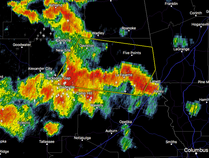
As I type this post, a Severe Thunderstorm Warning was just issued for the storm that I mentioned in Tallapoosa County.
We’ll continue to watch the weather situation as more storms could develop along with more moving in from Mississippi later tonight. We still have the same threats mentioned in earlier post… damaging wind gusts up to 60 MPH, along with a small threat of an isolated tornado or two. Stay tuned.
Category: ALL POSTS
About the Author (Author Profile)
Scott Martin is an operational meteorologist, professional graphic artist, musician, husband, and father. Not only is Scott a member of the National Weather Association, but he is also the Central Alabama Chapter of the NWA president. Scott is also the co-founder of Racecast Weather, which provides forecasts for many racing series across the USA. He also supplies forecasts for the BassMaster Elite Series events including the BassMaster Classic.Subscribe
If you enjoyed this article, subscribe to receive more just like it.


