Update on the Alabama Weather Situation at 8 a.m.
We had expected a batch of showers and storms to affect Central Alabama this morning and that is underway.
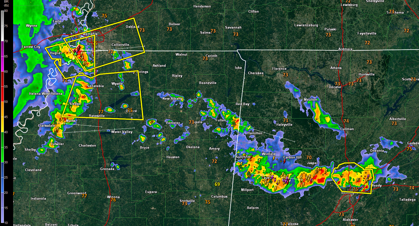
Storms over Fayette, Walker and Jefferson County are capable of producing damaging winds, very heavy rain, and lightning.
Doppler radar indicates 46-knot winds at 2,000 feet in the storms. That would be 55 mph. There is a decent amount of downdraft CAPE to help propel damaging winds to the surface, so be alert and be in a safe place where trees won’t crash into you as the storms pass.
One hour rainfall rates are running 1-2 inches in these storms, so flooding may be a problem. An areal flood advisory has been issued for parts of Blount, Jefferson and Walker Counties. A new flood advisory was just issued for Lamar County.
A cold front extends across Kentucky and western Tennessee this morning, turning into a stationary front across Arkansas and North Texas. The current storms are being fueled by warm low-level air coming up from the south, so they may persist into late morning. They are being aided as well by a patch of stronger winds at 18,00 feet that are moving across Central Alabama. The belt of westerly mid-level winds lies across North Alabama up into Tennessee and Kentucky this morning, something you don’t usually see in summer. This is helping to keep the storms organized.
To the west, additional storms crossing the Mississippi River will affect us later today and could be severe this afternoon. That system is taking on the appearance of a mesoscale convective vortex, so it could hold together for a while. That complex has lots of vorticity with it as well, also portending its strength. These storms may be a significant damaging wind producer when they reach Northwest Alabama around noon. They would work through North and Central Alabama during the afternoon, reaching I-59 around 3-4 p.m. and pushing completely into Georgia around 8 p.m.
The SPC does have their standard day one “slight risk” in effect for basically the northern half of Alabama meaning severe weather is possible.
So, a busy day is in store here in the weather office. We will have frequent updates and the latest alerts instantly here on AlabamaWX.
Category: Alabama's Weather, ALL POSTS
About the Author (Author Profile)
Bill Murray is the President of The Weather Factory. He is the site's official weather historian and a weekend forecaster. He also anchors the site's severe weather coverage. Bill Murray is the proud holder of National Weather Association Digital Seal #0001 @wxhistorianSubscribe
If you enjoyed this article, subscribe to receive more just like it.


