The Latest on the Alabama Weather Situation Just Before 7 p.m.
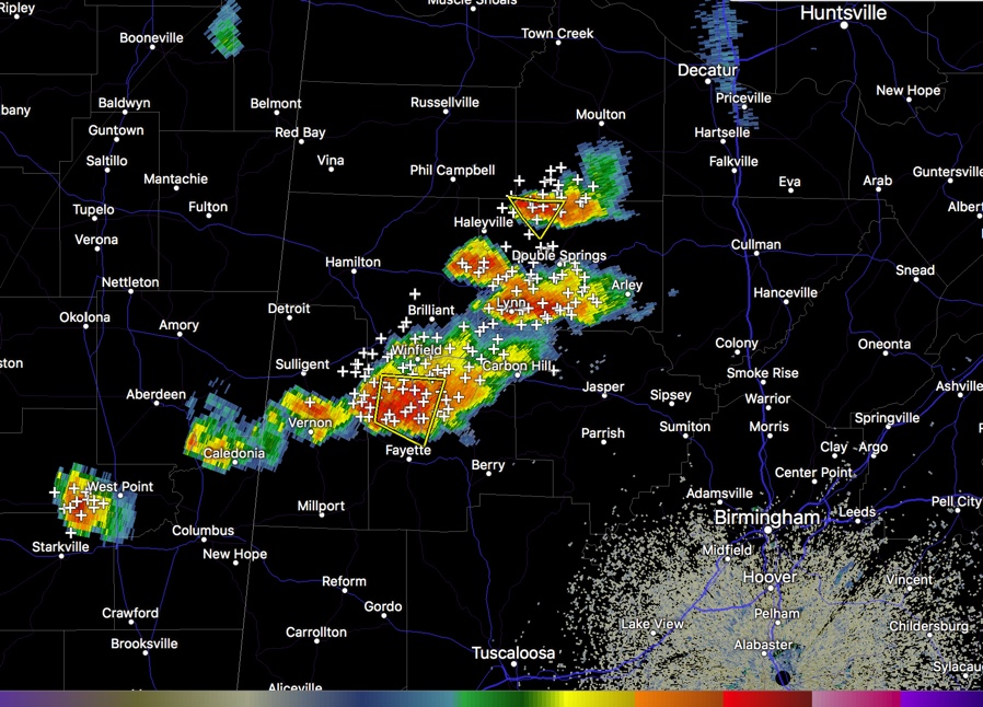
Strong thunderstorms continue pushing westward across West Alabama at this hour. The extend from southern Lawrence into Winston County, south of Double Springs, on to southern Marion and northern Fayette Counties. They are strongest between Winfield and Fayette.
There are others back across Lamar County near Vernon and then into Lowndes County, Mississippi, passing north of Caledonia.
We will have to watch storms north of Starkville, Mississippi as well. Those are pushing east and will affect parts of Lamar or northern Pickens Counties eventually.
A severe thunderstorm warning is in effect for parts of Fayette County. The Lamar County portion has been canceled. There is some broad rotation about to cross highway 43 north of Fayette.
There is also a severe thunderstorm warning for northern Winston County, north of Double Springs.
Yesterday’s severe thunderstorm warning is a reminder that tornadoes can and do occur in severe thunderstorm warnings, so they must be taken seriously. Especially when the environment is favorable as it was yesterday and today. Both of the current severe thunderstorm warnings that the NWS Birmingham has in effect have TORNADO…POSSIBLE tags in them.
A tornado watch remains in effect for Lamar, Fayette, Walker, Cullman and Blount Counties northward into southern Tennessee. This watch is in effect until 10 p.m.
Category: Alabama's Weather, ALL POSTS
About the Author (Author Profile)
Bill Murray is the President of The Weather Factory. He is the site's official weather historian and a weekend forecaster. He also anchors the site's severe weather coverage. Bill Murray is the proud holder of National Weather Association Digital Seal #0001 @wxhistorianSubscribe
If you enjoyed this article, subscribe to receive more just like it.


