

Midday Update: Not as Many Storms Today
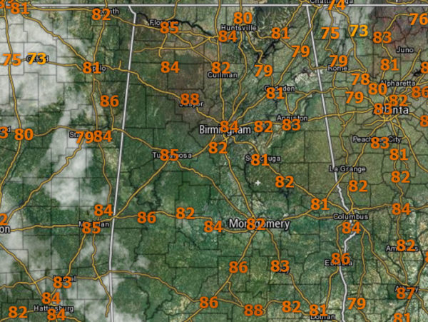
THE REST OF TODAY: After yesterday’s storms we need a break, and for the most part, that will be the case, but we are still expecting some storms this afternoon. Now the coverage in afternoon storms will be much lower today and not as intense, but it is a summer afternoon and we are going to be seeing scattered afternoon storms. It is another hot and humid day for the state, but there is no heat advisory today. Temperatures are in the lower to upper 80s at midday and should top out in the 90s for most location; heat index values will be around 100°.
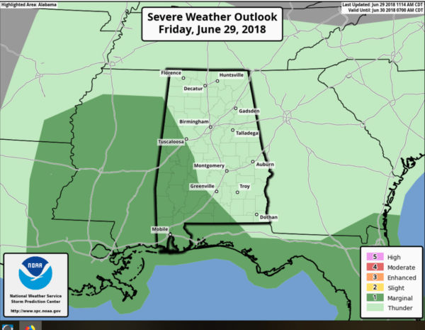
We do expect scattered storms this afternoon and this evening; stronger ones should be over the western side of the state where SPC has a “marginal risk” of severe storms defined for extreme and southwestern portions of the state.
As we see each day, any storm out there will be producing gusty winds, small hail, intense rainfall, and loads of lightning, which tends to be the most dangerous threat associated with storms. Of course in the risk area, there could be more of a threat for damaging winds.
Looking at the radar at midday, not much showing up, but that will change as we get to the peak heating of the day and instability values max out. Once again, the atmosphere was really worked over by the storms yesterday, but we are going to see showers and storms develop.
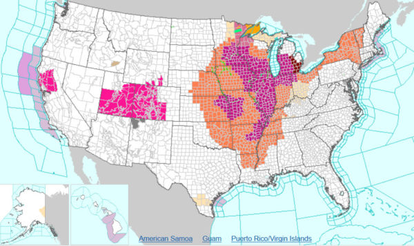
ACROSS THE USA: A major heat wave is already consuming much of the Central States and Midwest into the South. Widespread Excessive Heat Warnings and Advisories stretch from the Plains eastward and will reach the Great Lakes, Northeast and Mid-Atlantic states over the weekend. Meanwhile, Elevated to Critical fire weather threats will persist through the weekend from north-central CA to the Four Corners region.
THE ALABAMA WEEKEND: Both days will feature a mix of sun and clouds with scattered, mostly afternoon and evening showers and storms. The storms will be random and there is no way of knowing exactly where they form in advance. Rain chances will be in the 40-50% range, so better than average for this time of year, but still no complete washout. Highs will be in the low 90s for most locations.
HELLO JULY: We will continue with a persistence forecast through next week. No signs of any big upper high that will put a lid on convection, so each day we will have lots of sun during the morning hours, and scattered strong storms during the afternoon and evening. No way of knowing in advance when and where these will develop, but they will be out there. Highs will be in the upper 80s and lower 90s, while heat index values should be around the 100 degree mark.
TROPICAL OUTLOOK: All remains very quiet across the Atlantic basin, and tropical storm formation is not expected through next week.
THE ALABAMAWX BEACH FORECAST CENTER: Click here to see the AlabamaWx Beach Forecast Center page.
WORLD TEMPERATURE EXTREMES: Over the last 24 hours, the highest observation outside the U.S. was 118.6F at Qarn, Oman. The lowest observation was -105.0F at Dome C, Antarctica.
CONTIGUOUS TEMPERATURE EXTREMES: The highest observation was 116F at Death Valley, CA. The lowest observation was 37F at Leadville, CO and Truckee, CA.
WEATHER ON THIS DATE IN 1954: Hurricane Alice dumped as much as 27 inches of rain on the Lower Rio Grande Valley of Texas. The Rio Grande River at Laredo reached a level 12.6 feet above its previous highest mark, and the roadway of the U.S. 90 bridge was thirty feet below the high water.
Category: Alabama's Weather, ALL POSTS
About the Author (Author Profile)
Macon, Georgia Television Chief Meteorologist, Birmingham native, and long time Contributor on AlabamaWX. Stormchaser. I did not choose Weather, it chose Me. College Football Fanatic. @Ryan_StinnetSubscribe
If you enjoyed this article, subscribe to receive more just like it.


