At Midday: Some Sun, Some Clouds, Getting Hot
CONDITIONS ACROSS CENTRAL ALABAMA AT 11:55 AM
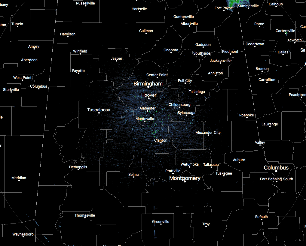
As we near the noon hour in Central Alabama, everyone in the area at this point is free from rain, but we do notice some shower activity in the northeast corner of the state just north of the area. These showers are moving southwest and will be affecting Fort Payne very shortly. Some of these showers may fall along and just inside the Cherokee County line as they move southwesterly. Temperatures are up in the mid to upper 80s at this point, with Birmingham sitting at 86 degrees. Tuscaloosa is the only location in the 90s at 90 degrees. The only other location in the whole state at 90 degrees is the Mobile Downtown Airport.
WHAT TO EXPECT FOR THE REST OF YOUR THURSDAY
It will be another hot afternoon across Central Alabama with partly cloudy skies and a chance of isolated to scattered showers and thunderstorms, with the higher chances being in the northern parts of the area (north of a line from Fayette to Birmingham to Anniston. Afternoon highs will be up in the upper 80s to the mid-90s. While most of the shower and storm activity diminishes as we move into the evening and late night hours, a shower or two could linger into the late night and even into the overnight hours. Lows will be in the lower to mid-70s.
MORE SHOWERS AND STORMS EXPECTED FOR FRIDAY
A cold front will be approaching the area on the last day of the work week, that will mean we will have an increase in rain chances, along with coverage in those showers and storms. We’ll have some sun with scattered to numerous showers and thunderstorms, becoming more active in the afternoon hours. A few storms could become strong with gusty winds as the main threat. Afternoon highs will be in the upper 80s to the mid-90s. Coverage in showers and storms will be the northern parts of the area, but all of Central Alabama will have a decent chance of storms. A chance of showers and storms will continue into the evening and through the late night and overnight hours with chances being highest in the southern half of the area. Lows will be in the lower to mid-70s.
AN UPDATE ON THE TROPICS
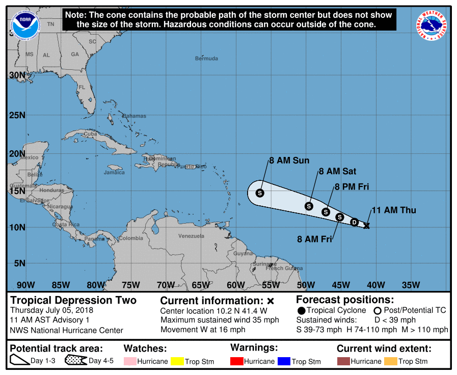
Tropical Depression Two has formed over the central tropic Atlantic and at this point is not a threat to land. It may strengthen into a Tropical Storm which would give it the name of Beryl. It will run into harsh conditions during the weekend that will cause it to degenerate into an open trough before it reaches the Lesser Antilles.
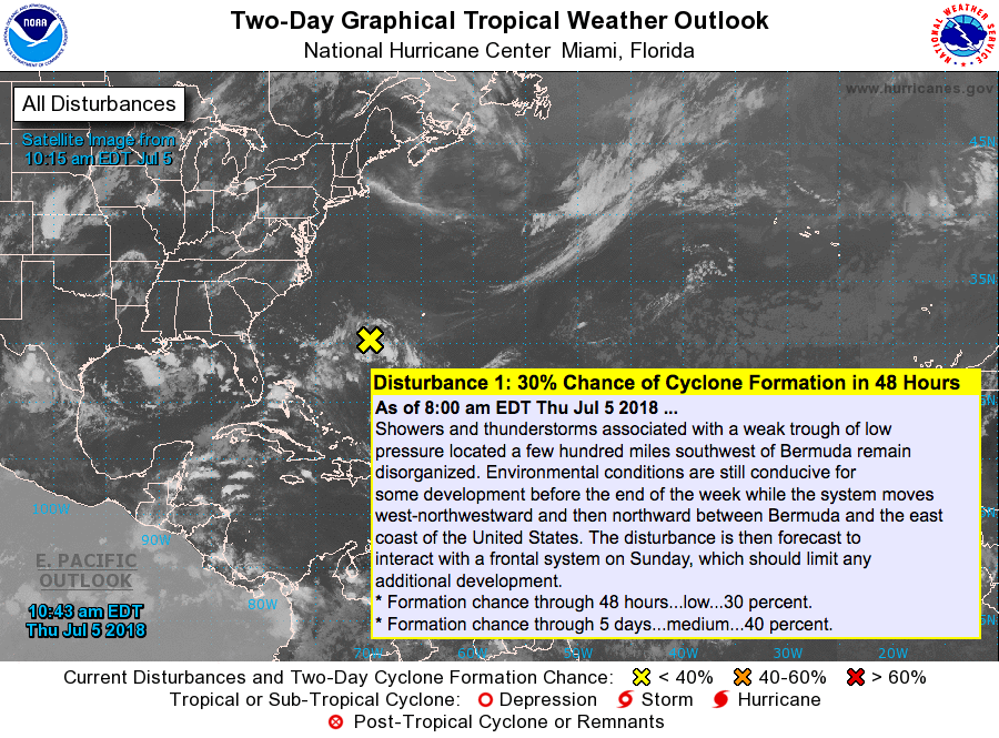
A weak trough of low pressure continues to sit a few hundred miles southwest of the island of Bermuda and still shows disorganized shower and storm activity. The environment should allow for some strengthening as the disturbance moves in between the US Mainland and Bermuda, possibly becoming a tropical depression. Strengthening will be shunted by Sunday as the system interacts with a frontal system. No threat to the US at this time.
BEACH FORECAST CENTER
Get the latest weather and rip current forecasts for the beaches from Fort Morgan to Panama City on our Beach Forecast Center page. There, you can select the forecast of the region that you are interested in.
ON THIS DAY IN WEATHER HISTORY
1988 – Afternoon and evening thunderstorms spawned eleven tornadoes in Montana and three in North Dakota. Baseball size hail was reported at Shonkin, MT, and wind gusts to 85 mph were reported south of Fordville, ND. Twenty cities in the north central U.S. reported record high temperatures for the date, including Fargo ND with a reading of 106 degrees. Muskegon, MI, equalled their July record with a high of 95 degrees.
1989 – Moisture from what once was Tropical Storm Allison triggered thunderstorms over the Middle Atlantic Coast Region, which deluged Wilmington, DE, with a record 6.83 inches of rain in 24 hours, including 6.37 inches in just six hours. Up to ten inches of rain was reported at Claymont, northeast of Wilmington. July 1989 was thus the wettest month in seventy years for Wilmington, with a total of 12.63 inches of rain. Alamosa CO reported an all-time record high of 94 degrees, and Pierre, SD, hit 113 degrees.
WE’RE HAVING A RECORD-BREAKING YEAR… ADVERTISE WITH US TODAY!
Don’t miss out! We have enjoyed over 11.7 MILLION page views on AlabamaWx.com since the start of 2018. We can customize a creative, flexible and affordable package that will suit your organization’s needs. Contact Bill Murray at (205) 687-0782.
E-FORECAST
Get the AlabamaWx Weather Blog’s Seven-Day Forecast delivered directly to your inbox by email twice daily. It is the most detailed weather forecast available in Central Alabama. Subscribe here… It’s free!
WEATHERBRAINS
Don’t forget you can listen to our weekly 90 minute netcast anytime on the web at WeatherBrains.com or on iTunes. This is the show all about weather featuring many familiar voices, including the meteorologists at ABC 33/40.
Category: Alabama's Weather, ALL POSTS
About the Author (Author Profile)
Scott Martin is an operational meteorologist, professional graphic artist, musician, husband, and father. Not only is Scott a member of the National Weather Association, but he is also the Central Alabama Chapter of the NWA president. Scott is also the co-founder of Racecast Weather, which provides forecasts for many racing series across the USA. He also supplies forecasts for the BassMaster Elite Series events including the BassMaster Classic.Subscribe
If you enjoyed this article, subscribe to receive more just like it.


