At Midday… Hot & Dry In The East, Scattered Storms In The West
CONDITIONS ACROSS CENTRAL ALABAMA AT 11:45 AM
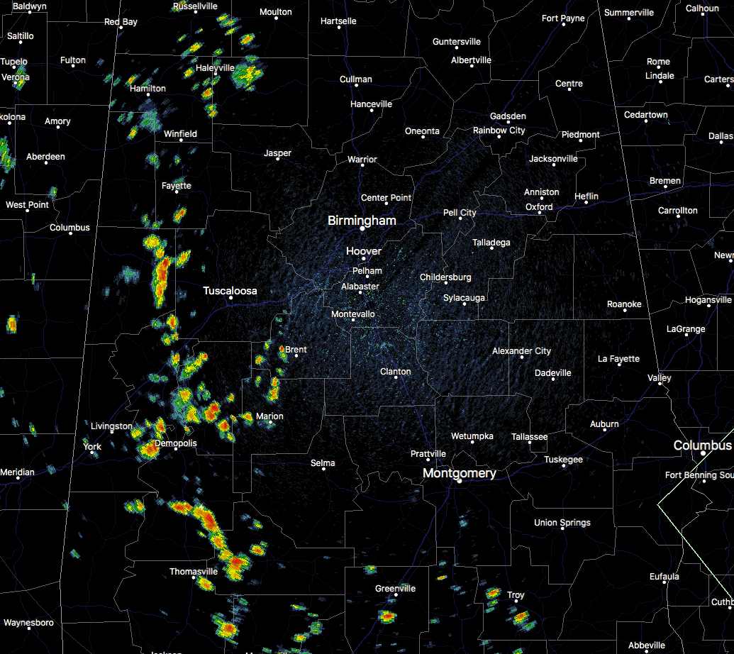
Just as the afternoon progressed on Monday with showers and a few storms staying mainly west of I-65, the trend is happening again at the midday hour today. We have scattered shower activity with a few heavy downpours out there across the western parts of the area mainly west of a line from Double Springs to Brookwood to Selma. At this point there are no lightning strikes showing up on radar, but there may be a few rumbles of thunder with those showers located in portions of Pickens, Greene, Hale, and Marengo counties. With the exception of those isolated showers in Pike County, all of Central Alabama east of I-65 is dry. Temperatures are in the mid-80s to the lower 90s already throughout the area, with Montgomery already at 91 degrees. Birmingham is not too far behind at 90 degrees.
WEATHER FOR THE REST OF YOUR TUESDAY
If you are east of the I-65 corridor today, you have a pretty good shot of staying dry as rainfall chances are so small that it is almost not worth mentioning, but it is the summertime, so there will be a very small chance for a stray shower or thunderstorm throughout the afternoon. West of I-65, chances increase as you go west from the corridor (20-40% for any one location). Afternoon highs will top out lower to mid-90s. Much of the activity will diminish after we lose the heating of the day, but one or two may linger over the western and southwestern parts of the area. Overnight lows will be in the lower to mid-70s.
THE LATEST ON TROPICAL STORM CHRIS
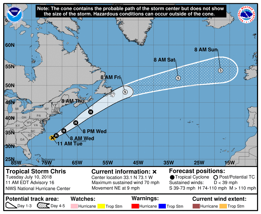
As of 10:00 AM CDT, Tropical Storm Chris is located around 200 miles southeast of Cape Hatteras, North Carolina, with maximum sustained winds at 70 MPH. Chris has now started moving to the northeast at 9 MPH and moving away from the US Mainland, and is expected to accelerate later this evening and into Wednesday. Chris may briefly strengthen into a hurricane later today as conditions become more conducive, but by Thursday night or Friday morning, it should transition into a strong post-tropical cyclone. People along the North Carolina coast and northward will see an increase in swells generated by Chris throughout the next few days, which could lead to dangerous rip currents.
HOW ABOUT THE REMNANTS OF BERYL
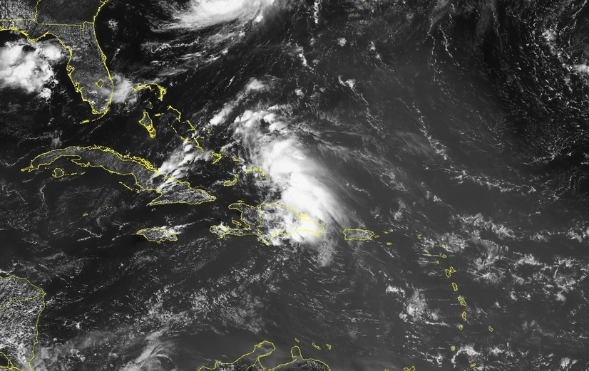
The remnants of Beryl are moving to the west-northwest over parts of central and eastern Hispaniola and is expected to move over the southeastern Bahamas later today. Wind shear and land interaction will keep any strengthening from happening today, but a turn to the north is expected on Wednesday and conditions will become more conducive for organization. It has a 50/50 chance of regenerating into a depression or tropical storm within the next 5 days, but it is expected to stay well away from the US Mainland.
BEACH FORECAST CENTER
There will be a good bit of sunshine each day through the rest of the week with only a chance of a scattered shower or storm, but rain chances will be on the increase for the weekend. Highs will be in the upper 80s to near 90 degrees. Get the latest weather and rip current forecasts for the beaches from Fort Morgan to Panama City on our Beach Forecast Center page. There, you can select the forecast of the region that you are interested in.
ON THIS DAY IN WEATHER HISTORY
1913 – The mercury hit 134 degrees at Greenland Ranch in Death Valley, CA, the hottest reading of record for the North American continent. Sandstorm conditions accompanied the heat. The high the previous day was 129 degrees, following a morning low of 93 degrees.
1926 – A lightning bolt struck an ammunition magazine in northern New Jersey, and a big red ball of fire leaped into the air triggering a series of explosions. All buildings within a half mile radius were destroyed, and debris fell as far as twenty-two miles away. Sixteen persons were killed, and property damage was seventy million dollars.
LOOK BEFORE YOU LOCK
Never leave children, disabled or elderly adults, or pets in parked vehicles. Studies have shown that the temperature inside a parked vehicle can rapidly rise to a dangerous level for children, pets and even adults. Leaving the windows slightly open does not significantly decrease the heating rate. The effects can be more severe on children because their bodies have not developed the ability to efficiently regulate internal temperature. Heat related deaths are preventable, so look before you lock.
WE’RE HAVING A RECORD-BREAKING YEAR… ADVERTISE WITH US TODAY!
Don’t miss out! We have enjoyed over 11.7 MILLION page views on AlabamaWx.com since the start of 2018. We can customize a creative, flexible and affordable package that will suit your organization’s needs. Contact Bill Murray at (205) 687-0782.
E-FORECAST
Get the AlabamaWx Weather Blog’s Seven-Day Forecast delivered directly to your inbox by email twice daily. It is the most detailed weather forecast available in Central Alabama. Subscribe here… It’s free!
WEATHERBRAINS
Don’t forget you can listen to our weekly 90 minute netcast anytime on the web at WeatherBrains.com or on iTunes. This is the show all about weather featuring many familiar voices, including the meteorologists at ABC 33/40.
Category: Alabama's Weather, ALL POSTS
About the Author (Author Profile)
Scott Martin is an operational meteorologist, professional graphic artist, musician, husband, and father. Not only is Scott a member of the National Weather Association, but he is also the Central Alabama Chapter of the NWA president. Scott is also the co-founder of Racecast Weather, which provides forecasts for many racing series across the USA. He also supplies forecasts for the BassMaster Elite Series events including the BassMaster Classic.Subscribe
If you enjoyed this article, subscribe to receive more just like it.


