

At Midday: Hot & Very Humid, Some Cooling Showers Already Developing
CONDITIONS ACROSS CENTRAL ALABAMA AT 11:30 AM
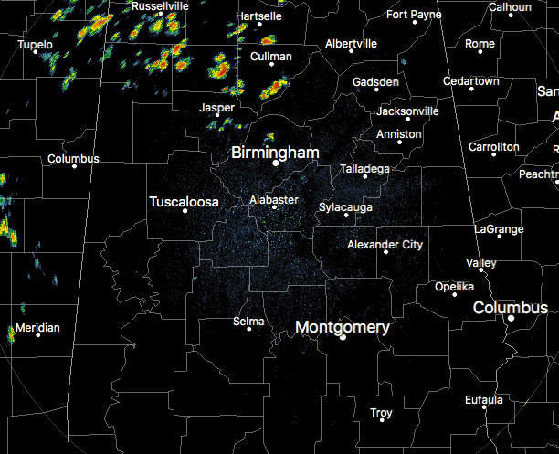
It’s already a hot one out there throughout the area as temperatures have already hit the mid-80s to the lower 90s. The hot spot at this time was Eufaula at 92 degrees, while the Magic City was at 90 degrees. The cool spot is Haleyville as they have rain-cooled air and is sitting at 77 degrees. Scattered showers have already developed in the northwestern-quarter of Central Alabama, mostly in Marion, Winston, and Cullman counties. A few more can be found in parts of Walker and Jefferson counties. The rest of Central Alabama is dry at this time.
FORECAST FOR THE REMAINDER OF YOUR WEDNESDAY
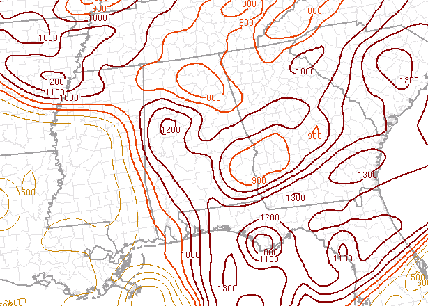
It will be another hot and humid day throughout Central Alabama as the effects of Chris have moved farther out to see. We’ll have more moisture available today, meaning humidity values will be higher. That also means we’ll have the standard chance of scattered afternoon and evening showers and storms, with most of the area having around 30% for any one location. Looking at the latest SPC Mesoscale Analysis, there may be a possibility that a few storms could produce gusty winds strong enough to knock a few tree limbs down, as D-CAPE values are already running in the 800-1200 J/kg (shown in above image). Anything over 1000 J/kg shows potential for damaging thunderstorm downdrafts, and the higher you go, the higher the possibility. Afternoon highs will be in the lower to mid-90s throughout the area. For this evening and throughout the night time hours, showers and storms will diminish as we lose the heating of the day, and we should be nearly rain free by 10:00 PM. We’ll be left with mostly clear skies with lows in the lower to mid-70s.
THE LATEST ON HURRICANE CHRIS
Category 2 Hurricane Chris continues to move off into the open waters of the Atlantic and will soon become post-tropical on Thursday. No threat to the US Mainland and surf conditions will improve along the Atlantic Coast.
HOW ABOUT THE REMNANTS OF BERYL
Beryl is still considered a tropical wave today and is not forecasted to strengthen today. A reconnaissance flight was scheduled to fly through the disturbance today but was cancelled. Some reorganization could occur within the next few days and Beryl may reform into a tropical depression. NHC is giving it a 50% chance within the next 5 days. At this point, it is not a threat to the US Mainland as it is projected to move north then northeastward. We’ll keep an eye on it to see where the path goes.
BEACH FORECAST CENTER
Get the latest weather and rip current forecasts for the beaches from Fort Morgan to Panama City on our Beach Forecast Center page. There, you can select the forecast of the region that you are interested in.
LOOK BEFORE YOU LOCK
Never leave children, disabled or elderly adults, or pets in parked vehicles. Studies have shown that the temperature inside a parked vehicle can rapidly rise to a dangerous level for children, pets and even adults. Leaving the windows slightly open does not significantly decrease the heating rate. The effects can be more severe on children because their bodies have not developed the ability to efficiently regulate internal temperature. Heat related deaths are preventable, so look before you lock.
WE’RE HAVING A RECORD-BREAKING YEAR… ADVERTISE WITH US TODAY!
Don’t miss out! We have enjoyed over 11.9 MILLION page views on AlabamaWx.com since the start of 2018. We can customize a creative, flexible and affordable package that will suit your organization’s needs. Contact Bill Murray at (205) 687-0782.
E-FORECAST
Get the AlabamaWx Weather Blog’s Seven-Day Forecast delivered directly to your inbox by email twice daily. It is the most detailed weather forecast available in Central Alabama. Subscribe here… It’s free!
WEATHERBRAINS
Don’t forget you can listen to our weekly 90 minute netcast anytime on the web at WeatherBrains.com or on iTunes. This is the show all about weather featuring many familiar voices, including the meteorologists at ABC 33/40.
Category: Alabama's Weather, ALL POSTS
About the Author (Author Profile)
Scott Martin is an operational meteorologist, professional graphic artist, musician, husband, and father. Not only is Scott a member of the National Weather Association, but he is also the Central Alabama Chapter of the NWA president. Scott is also the co-founder of Racecast Weather, which provides forecasts for many racing series across the USA. He also supplies forecasts for the BassMaster Elite Series events including the BassMaster Classic.Subscribe
If you enjoyed this article, subscribe to receive more just like it.


