At Midday: Another Hot Day With Scattered Showers & Storms
CONDITIONS ACROSS THE AREA AT 12:15 PM
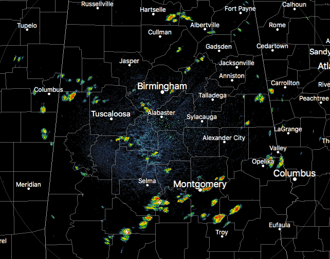
At this point on your Thursday midday, we have scattered showers and storms dotting the radar in the north, the south, the east, and in the west. I guess you can just call that “compass coverage.” Much of the activity is located in the southern parts of the area mainly from just west of Tallassee to Montgomery to Hayneville and down into South Alabama. All of this activity across the area is moving very slowly to the south. Temperatures are in the upper 80s to the lower 90s, with Birmingham currently sitting at 90 degrees. Montgomery is the hot spot at 93 degrees, while the cool spot is Bessemer at 88 degrees. Heat index values are already up in the 96-104 degree range, so take it easy out there.
WEATHER FOR THE REST OF YOUR THURSDAY
We’ll have hot and humid conditions throughout the remainder of the afternoon and into the early evening hours, with your standard chance of scattered showers and thunderstorms. Afternoon highs will be in the lower to mid-90s. For this evening, those showers and storms will start to diminish as we lose the heating of the day, and we should mainly be rain-free by 11:00 PM tonight. It is possible that a shower or two could linger into the overnight hours. Lows will be in the lower to mid-70s.
THE LATEST ON CHRIS
Chris is now post-tropical and continues to accelerate to the northeast away from the United States, but may skate over or come near to the Avalon Peninsula of Newfoundland later today. After that, we’ll have to worry about rough seas along the coastline for the next day or two.
HOW ABOUT THE REMNANTS OF BERYL
Beryl is still considered a tropical wave today and is not forecasted to strengthen today. Some reorganization could occur within the next few days and Beryl may reform into a tropical depression as it moves over the warmer waters east of the US Atlantic Coast. NHC is giving it a 50% chance within the next 5 days. At this point, it is not a threat to the US Mainland as it is projected to move north then northeastward. We’ll keep an eye on it to see where the path goes.
BEACH FORECAST CENTER
Get the latest weather and rip current forecasts for the beaches from Fort Morgan to Panama City on our Beach Forecast Center page. There, you can select the forecast of the region that you are interested in.
LOOK BEFORE YOU LOCK
Never leave children, disabled or elderly adults, or pets in parked vehicles. Studies have shown that the temperature inside a parked vehicle can rapidly rise to a dangerous level for children, pets and even adults. Leaving the windows slightly open does not significantly decrease the heating rate. The effects can be more severe on children because their bodies have not developed the ability to efficiently regulate internal temperature. Heat related deaths are preventable, so look before you lock.
WE’RE HAVING A RECORD-BREAKING YEAR… ADVERTISE WITH US TODAY!
Don’t miss out! We have enjoyed over 11.9 MILLION page views on AlabamaWx.com since the start of 2018. We can customize a creative, flexible and affordable package that will suit your organization’s needs. Contact Bill Murray at (205) 687-0782.
E-FORECAST
Get the AlabamaWx Weather Blog’s Seven-Day Forecast delivered directly to your inbox by email twice daily. It is the most detailed weather forecast available in Central Alabama. Subscribe here… It’s free!
WEATHERBRAINS
Don’t forget you can listen to our weekly 90 minute netcast anytime on the web at WeatherBrains.com or on iTunes. This is the show all about weather featuring many familiar voices, including the meteorologists at ABC 33/40.
Category: Alabama's Weather, ALL POSTS
About the Author (Author Profile)
Scott Martin is an operational meteorologist, professional graphic artist, musician, husband, and father. Not only is Scott a member of the National Weather Association, but he is also the Central Alabama Chapter of the NWA president. Scott is also the co-founder of Racecast Weather, which provides forecasts for many racing series across the USA. He also supplies forecasts for the BassMaster Elite Series events including the BassMaster Classic.Subscribe
If you enjoyed this article, subscribe to receive more just like it.


