Don’t Be the Victim of a First Lightning Strike: Keep an Eye to the Sky, and Your Radar App Handy
We all know the precautionary saying, “When Thunder Roars, Go Indoors,” but that doesn’t work for the first strike. It hits BEFORE the first warning clap of thunder.
And the news this week that a 73-year old woman who was struck by lightning on June 28th in Huntsville has now succumbed to her injuries. She was reportedly inspecting a seawall and standing under a tree when lightning struck the tree.
This fatality has been inserted as #9 in the list below.
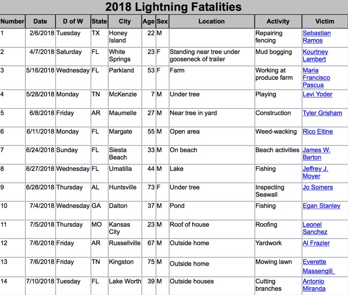
The U.S. has now seen 14 lightning fatalities this year. Based on the past 10 years, the U.S. averages 14 fatalities through July 12.
But you can protect yourself from lightning by keeping an eye to the sky. Or to your radar app. I will share a tip in a moment.
Warning Coordination Meteorologist John DeBlock sent this message yesterday to media partners in Central Alabama.
“Everybody loves the cool breezes and maybe even cooling rain from summer thunderstorms, but there still is a very real and inherent danger that comes along with them. If thunderstorms are in the forecast, even a 20 or 30 percent chance, and you are outside in the hot and humid summer air after lunch, you really need to keep an eye to the sky. Summer thunderstorms can develop quickly in the heat of the early afternoon hours, and you might not have much of a warning before that first lightning strike occurs. So watch the skies, and if the clouds start getting tall, or you are directly under a darkening cloud, consider taking a break in a vehicle or indoors for a few minutes until you can be certain there isn’t a thunderstorm developing overhead or nearby. Typical summer thunderstorms can develop in less than 20 minutes, and last around a half an hour. Better to take a break and be safe than become the next lightning statistic!”
That’s great advice John.
One other tip for the more weather-savvy folks in the audience. Use the Composite Reflectivity mode on your RadarScope app or Gibson Ridge program (and some others as well) to see developing storms that have large volumes of hydrometeors suspended aloft. Once this rain and hail reach an altitude (usually about 30,000 feet) that is sufficient to produce the necessary charge separation, lightning will be the result. Looking at the reflectivity mode, you might not see much precipitation reaching the ground. But the composite reflectivity can reveal a different story.
Here is an example using a storm John cited from this week:
A thunderstorm developed rapidly on Birmingham’s east side between 4:30 and 5 p.m. Thursday afternoon.
At 4:32, the first few raindrops are hitting the ground, but the shower doesn’t look like much on base reflectivity, shown on the left panel. But the composite on the right, which adds together the reflectivity from all the tilts, shows a much different picture:
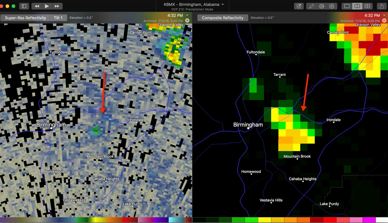
Within 5 minutes, the storm was producing lightning, even though the precipitation was not very heavy yet.
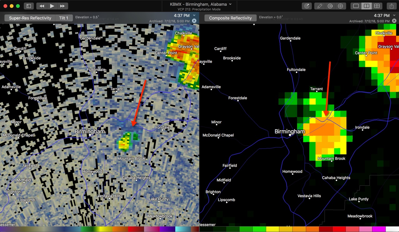
By 4:55 p.m., the storm was producing heavy rain, frequent lightning, small hail and very strong winds in the Crestwood area of Birmingham as shown in the base reflectivity. The composite image indicates the storm was collapsing, sending all that rain, hail and wind to the ground.
But as you can see, even before the rain starts to fall in earnest, the composite data can give you a few precious minutes to get in a vehicle or go indoors before the first strike. Use it and your eyes to be safe around developing thunderstorms.
Category: Alabama's Weather, ALL POSTS
About the Author (Author Profile)
Bill Murray is the President of The Weather Factory. He is the site's official weather historian and a weekend forecaster. He also anchors the site's severe weather coverage. Bill Murray is the proud holder of National Weather Association Digital Seal #0001 @wxhistorianSubscribe
If you enjoyed this article, subscribe to receive more just like it.


