Still All Quiet As We’ve Hit The 1:00 AM Hour
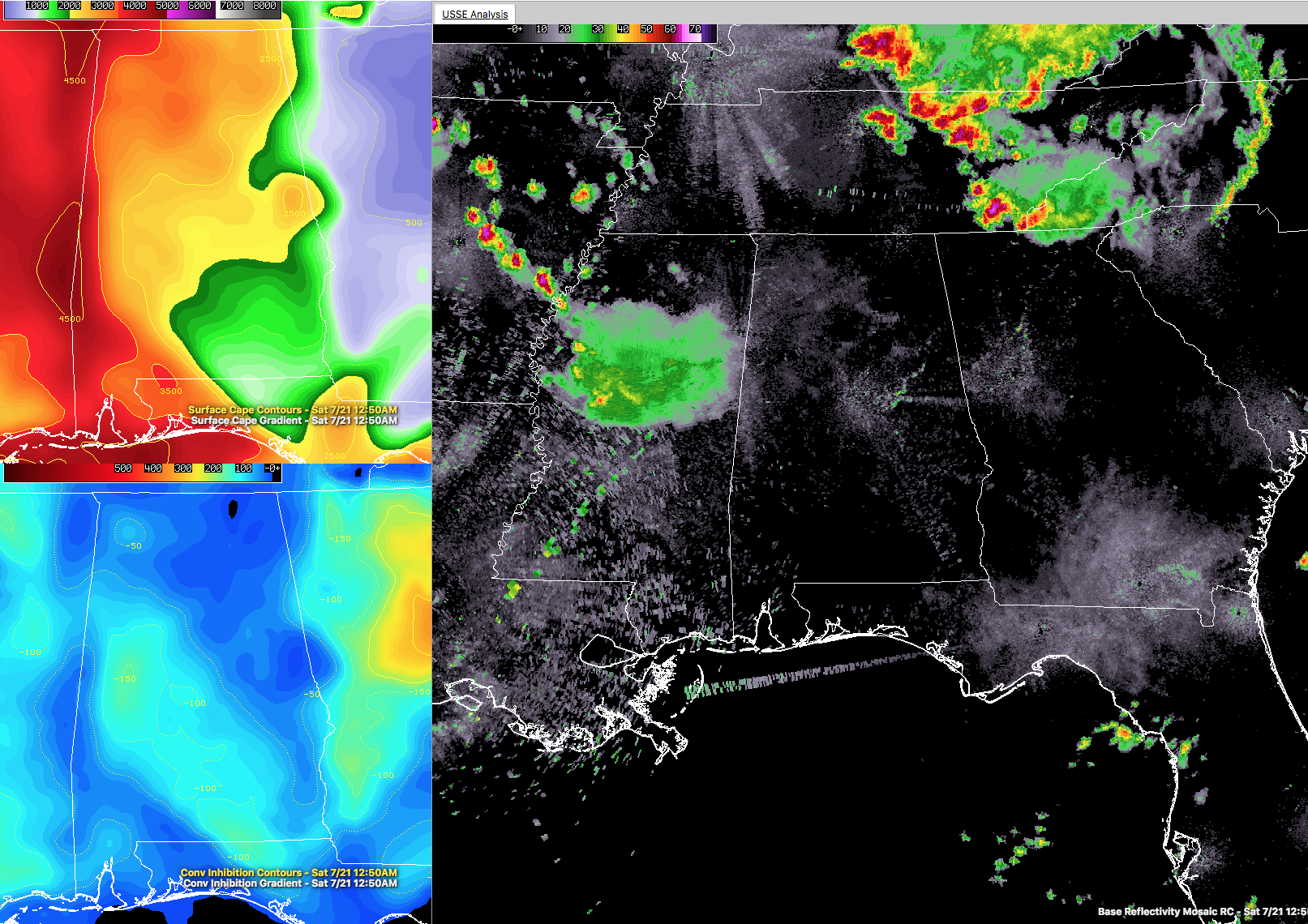
As we take a look at the above image, we can see that the state of Alabama is still lacking in the department of shower and thunderstorm activity. We still have a good bit of instability across North and Central Alabama, ranging from 1500 to 4500 J/kg (top right box on image). We also have a good bit of wind shear, and with both of those ingredients together, we still have an environment across the area that can support severe weather. The only problem is that there is a cap (convective inhibition, bottom left box on image) in place over the area, and with no focusing mechanism to break through the cap, conditions will stay quiet across the area.
With all of that being said, NWS Huntsville will continue the Tornado Watch for nearly all of its counties until it expires at 2:00 AM. It looks doubtful at this point for the issuance of any new watches as the trends on radar continues to show weakening and some dissipation of showers and storms in Mississippi that was expected to move into extreme western portions of Central Alabama. They have died down into a batch of light to moderate showers over the central parts of Mississippi.
More storms have formed way back in Arkansas, with a few of those having severe thunderstorm warnings issued on them. If they hold together and stay on their current trajectory, it would be between 6-7 hours before arriving in the western parts of Central Alabama.
There are also strong to severe storms that are pushing through the eastern parts of Kentucky and Tennessee, moving to the southeast into northern Georgia and the Carolinas. The latest radar scans show a outflow boundary that is a catalyst for more storms firing up as it moves more due south. That boundary is moving across Morristown, Tennessee at the moment, and if it holds together for several hours, it will eventually work into the northeast corner of North Alabama. That could occur somewhere in the next 3-5 hours.
I’m up all night long keeping you up to date on the blog. We’ve got a while before we have to worry about any storms in North and Central Alabama, so go ahead and catch you a few winks.
Category: Alabama's Weather, ALL POSTS
About the Author (Author Profile)
Scott Martin is an operational meteorologist, professional graphic artist, musician, husband, and father. Not only is Scott a member of the National Weather Association, but he is also the Central Alabama Chapter of the NWA president. Scott is also the co-founder of Racecast Weather, which provides forecasts for many racing series across the USA. He also supplies forecasts for the BassMaster Elite Series events including the BassMaster Classic.Subscribe
If you enjoyed this article, subscribe to receive more just like it.


