A Few Notes on the Alabama Weather Situation Just After 9 a.m.; Severe Storms Possible This Afternoon/Evening
Things are calming for now across North and Central Alabama, but more active weather is going to occur this afternoon.
SEVERE THUNDERSTORM WATCH 297
The NWS in Huntsville has canceled the watch for their counties and the NWS Birmingham allowed their counties to expire at 9 a.m.
RADAR CHECK
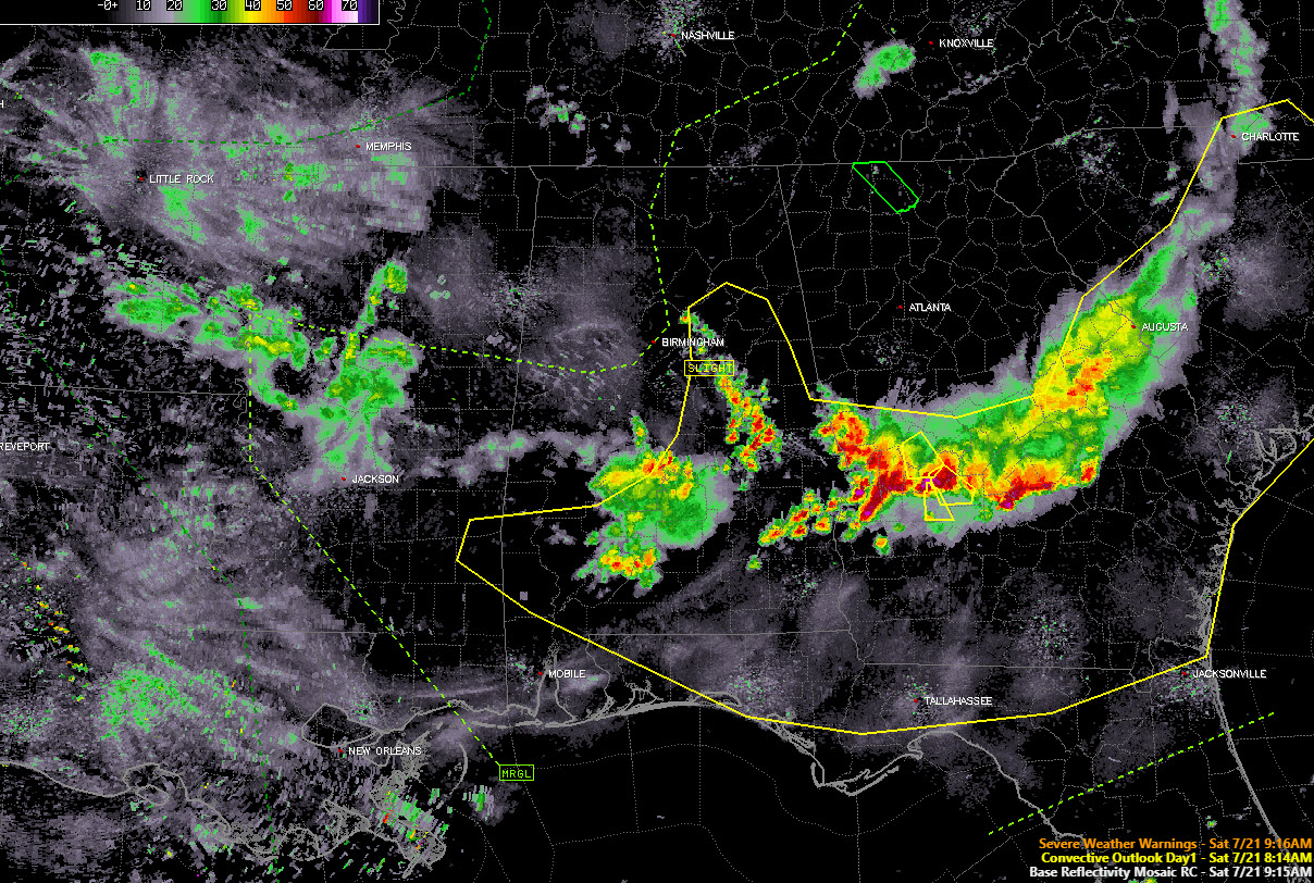
Two sets of storms have been affecting Alabama this morning. The tail end of a mesoscale convective system that has been diving southward over Georgia impacted eastern Alabama this morning. The last storms are leaving Chambers and Lee Counties in East Alabama right now. The main impact of this system will be to leave a boundary over East Alabama that storms can exploit later today. Watch for that to be a focus for stronger storms later this afternoon.
A weakening area of storms covers parts of Perry, Autauga, Dallas, Lowndes, Wilcox, Monroe and Conecuh counties at this hour. These storms will move into Southeast Alabama over the next few hours. They are not severe and significant weather advisories have been sufficient for them this morning.
MAP WALL
The players are on the field. We have an unusual surface low over Lake Michigan with a cold front near Memphis. That front pushes slowly southeast today and reaches I-20 by midnight tonight. Lots of cloud debris from the morning storms will limit heating in many spots which will reduce instability but the atmosphere should recover enough over the western part of the area for storms. Plenty of wind shear with a 500 millibar jet producing 50-60 knots of bulk shear. A strong 70-knot upper-level jet providing the dynamics. We have boundaries. Hmmm. Should be severe thunderstorms this afternoon and evening ahead of the front.
NEW DAY ONE
The new Storm Prediction Center Day One Severe Weather Outlook is out and it has been cut back substantially. It is now concentrated over East Central and South Alabama. The slight risk (level 2 of 5) includes Anniston, Talladega, Montgomery, Auburn, Greenville, Troy, and Dothan. It also includes a low-end tornado threat south and east of a line from Heflin to Ashville to Montgomery. This includes places like Anniston, Talladega, Alex City, Auburn, Montgomery and Phenix City. So, damaging winds the main threat but can’t rule out a tornado or two.
THANKS FOR NUTHIN’
The mesoscale models are no help right now with the timing and placement of storms. The HRRR sees no evil and hears no evil the rest of the day with no storms developing. Yeah, right. The WRF shows storms developing over eastern counties around 3-4 p.m. with nothing else happening. Wait, there’s a trend here. Maybe no storms develop ahead of the front, except near the boundary over East Alabama.
DID I SAY IT WAS A LOW CONFIDENCE FORECAST?
Well, I am saying it now. We won’t know what’s happening until we see the whites of its eyes. Pay attention to the sky and your trusted weather sources all day. We will have the latest up to the minute information here on the AlabamaWX weather blog all day.
Category: Alabama's Weather, ALL POSTS
About the Author (Author Profile)
Bill Murray is the President of The Weather Factory. He is the site's official weather historian and a weekend forecaster. He also anchors the site's severe weather coverage. Bill Murray is the proud holder of National Weather Association Digital Seal #0001 @wxhistorianSubscribe
If you enjoyed this article, subscribe to receive more just like it.


