At 4:15 PM – Stronger Storms In East Alabama, Quiet In The West
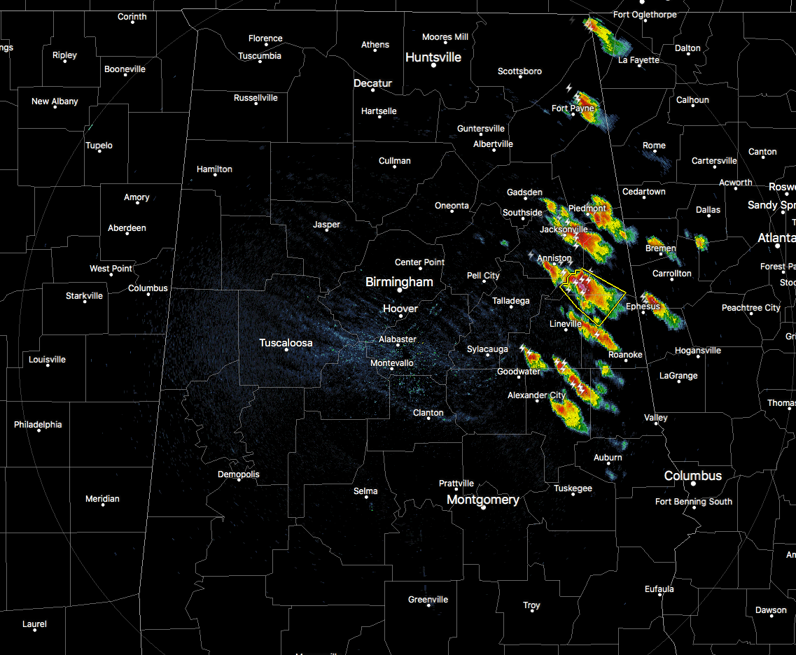
We have a good bit of storm activity firing up over the eastern and northeastern parts of the area, but the good news is that none of these are currently severe. As I just finished typing that last statement, a Severe Thunderstorm Warning was just issued for parts of Clay, Cleburne, and Randolph counties until 4:45 PM. This storms is moving to the southeast at 25 MPH. Winds up to 60 MPH and hail up to 1.25 inches in diameter will be possible. Take shelter immediately if you are in the path of this storm, including the communities of Anniston, Oxford, Oxford Lake, Morrison Cross Roads, Fosters Cross Roads, Delta, Dearmanville, Hollis Crossroads, Micaville, Chalafinnee, Choccolocco, and Camp Sequoyah.
It looks like that any additional develop may be limited as drier air continues to move into the area, and add that with shear being on the relatively strong side, the high instability values are being offset along with the stronger storms are not able to maintain their updrafts.
The window for any stronger to severe storms will be from now until around or just after 8:00 PM, when we lose the heating of the day. Main threats will be from damaging wind gusts up to 60 MPH and hail up to 1 inch in diameter. Looks like the very small tornado threat has now diminished. All activity will remain on the eastern half of the state, mainly closer to the Alabama/Georgia state line. Much, if not all, of North and Central Alabama may stay dry west of I-65.
We’ll have updates throughout the remainder of the day until the threat of severe weather passes. Keep checking back often for updates.
Category: Alabama's Weather, ALL POSTS
About the Author (Author Profile)
Scott Martin is an operational meteorologist, professional graphic artist, musician, husband, and father. Not only is Scott a member of the National Weather Association, but he is also the Central Alabama Chapter of the NWA president. Scott is also the co-founder of Racecast Weather, which provides forecasts for many racing series across the USA. He also supplies forecasts for the BassMaster Elite Series events including the BassMaster Classic.Subscribe
If you enjoyed this article, subscribe to receive more just like it.


