At Midday: A Little Cooler & Not Quite As Humid; A Few Showers Already Out There
Conditions Across Central Alabama At 11:15 AM
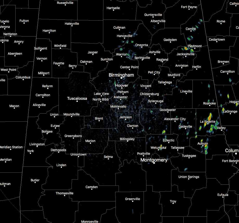
We are already starting to see showers popping up in the eastern half of Central Alabama as we are making the approach up to the noon hour. Heaviest showers at this point are over Chambers and Lee counties. The rest of the shower activity is smaller and spotty. All of the shower activity is moving to the south. For the rest of the area, clouds are covering much of the sky, but there are a few breaks of sunshine. Temperatures are currently in the mid-70s to the lower 80s, with the warmer air down in the southwestern pars of the area. Birmingham was at 81 degrees.
Weather For The Rest Of Your Monday
Drier air is starting to make its way towards Central Alabama, but we’ll continue to have very warm conditions for this afternoon. Skies will be partly to mostly cloudy with the best chance for scattered to numerous shower and thunderstorm activity being east of a line from Jasper (Walker Co.) to West Blocton (Bibb Co.) to Selma (Dallas Co.), higher the farther east you go. West of that line, there will be a small risk for a few isolated to scattered showers and thunderstorms. Afternoon highs will top out in the mid-80s to the lower 90s, but those may be held down in places due to cloud cover and rainfall. Through the evening and overnight hours, shower and storm chances will diminish as we approach the late night hours, but a stray shower or two may linger for a little while after midnight. Lows will be in the upper 60s to the lower 70s.
On This Day In Weather History
1989 – Morning thunderstorms in the central U.S. drenched central Oklahoma with up to six inches of rain. Afternoon thunderstorms produced wind gusts to 85 mph at Fort Smith, AR. Evening thunderstorms over Florida spawned a tornado which touched down three times in south Fort Myers causing nearly three quarters of a million dollars damage.
An Update On The Tropics
All quiet in the tropics, with nothing expected to form into a tropical depression or storm within the next 5 days.
Beach Forecast Center
Get the latest weather and rip current forecasts for the beaches from Fort Morgan to Panama City on our Beach Forecast Center page. There, you can select the forecast of the region that you are interested in.
We’re Having A Record-Breaking Year… Advertise With Us Today!
Don’t miss out! We have enjoyed over 12.6 MILLION page views on AlabamaWx.com since the start of 2018. We can customize a creative, flexible and affordable package that will suit your organization’s needs. Contact Bill Murray at (205) 687-0782.
E-Forecast
Get the AlabamaWx Weather Blog’s Seven-Day Forecast delivered directly to your inbox by email twice daily. It is the most detailed weather forecast available in Central Alabama. Subscribe here… It’s free!
WeatherBrains
Don’t forget you can listen to our weekly 90 minute netcast anytime on the web at WeatherBrains.com or on iTunes. This is the show all about weather featuring many familiar voices, including the meteorologists at ABC 33/40.
Category: Alabama's Weather, ALL POSTS
About the Author (Author Profile)
Scott Martin is an operational meteorologist, professional graphic artist, musician, husband, and father. Not only is Scott a member of the National Weather Association, but he is also the Central Alabama Chapter of the NWA president. Scott is also the co-founder of Racecast Weather, which provides forecasts for many racing series across the USA. He also supplies forecasts for the BassMaster Elite Series events including the BassMaster Classic.Subscribe
If you enjoyed this article, subscribe to receive more just like it.


