Mainly Sunny Saturday Afternoon
Drier air has filtered into Alabama today and that means few if any shower and storm activity this afternoon. A quick look at the radar shows not much at all showing up and for the rest of today we should be staying dry under the mix of sun and clouds.
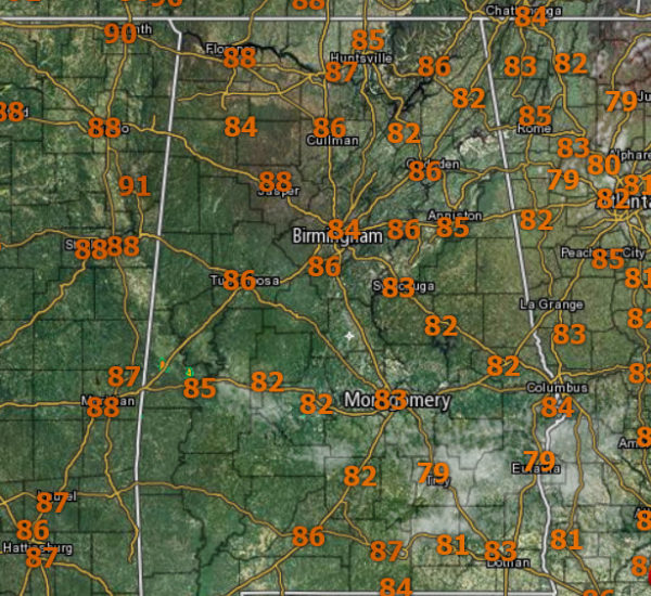
Temperatures are in the mid and upper 80s early this afternoon and we should see some spots into the lower 90s for highs. Tonight should be a clear and calm night with lows in the upper 60s to to lower 70s.
SCATTERED STORMS SUNDAY: Tomorrow, looks to starts with a good supply of sunshine during the morning, followed by some risk of scattered afternoon and evening storms. The chance of any one spot getting wet is about one in four, and the high will be near 90.
TROPICAL UPDATE: For the North Atlantic, Caribbean Sea and the Gulf of Mexico for the most part all is quiet. A couple of areas of interest.
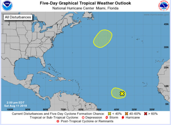
A disorganized area of showers and thunderstorms is located about midway between Africa and the Lesser Antilles. Some gradual development of this system is possible through early next week as it moves slowly westward. Formation chance through 5 days…low…20 percent.
A non-tropical area of low pressure is forecast to form over the central Atlantic in a few days. The low could gradually acquire subtropical or tropical characteristics while moving slowly northeastward during the middle of next week. Formation chance through 5 days…low…20 percent.
WEATHER ON THIS DATE IN 1940: A major hurricane struck Savannnah, GA, and Charleston, SC, causing the worst inland flooding since 1607.
Category: Alabama's Weather, ALL POSTS
About the Author (Author Profile)
Macon, Georgia Television Chief Meteorologist, Birmingham native, and long time Contributor on AlabamaWX. Stormchaser. I did not choose Weather, it chose Me. College Football Fanatic. @Ryan_StinnetSubscribe
If you enjoyed this article, subscribe to receive more just like it.


