

Some Sun, Some Clouds, Some Rain: It’s Your Midday Nowcast For Central Alabama
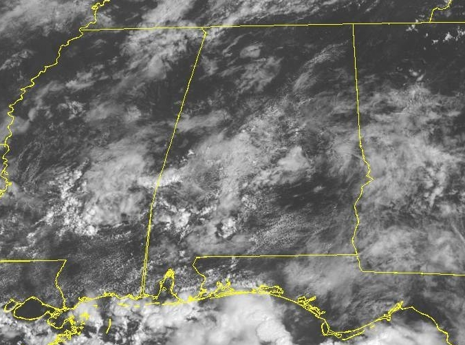
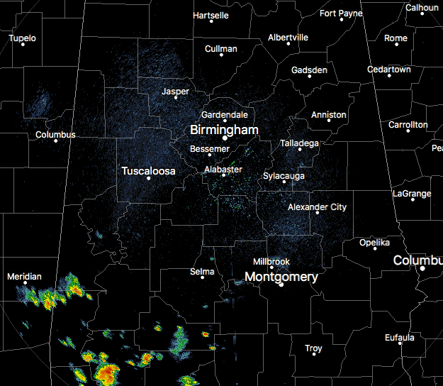
CONDITIONS AT 11:00 AM
While much of the area has mostly clear to partly cloudy skies, we already have showers and thunderstorms firing up over the southwestern parts of the area, mainly over the southern portions of Sumter County and down into the Mobile market. Temperatures are not all that bad at this point, ranging from the mid-70s to the lower 80s throughout Central Alabama. Birmingham was at 82 degrees, tied with a few locations as the warm spot.
WEATHER FOR THE REST OF YOUR THURSDAY
Weather will continue to be unsettled today with a good chance of scattered to numerous showers and thunderstorms through the afternoon and into the evening hours. Clouds will build throughout the heating of the day and afternoon highs will top out in the upper 80s to the lower 90s. Rain chances will be in the 50-60% range with the higher chances occurring south of a line from Tuscaloosa to Clanton to Montgomery. For this evening and into the late night hours, rain chances will diminish somewhat as we lose the heating of the day, but we can see a few showers or storms continue through midnight. All activity should come to an end well before sunrise. Lows will be in the upper 60s to the lower 70s.
UNSETTLED WEATHER CONTINUES FOR FRIDAY
It will be another typical summertime day in Central Alabama with some sun but clouds will hamper much of that. Scattered showers and storms will once again fire up during the heating of the day, but the good news is that rain chances will be a little less than today, around 40%. Afternoon highs will be in the upper 80s for the most part, with a few locations briefly touching the lower 90s.
UAB FOOTBALL FORECAST
We’ll have more clouds than stars tonight over Legion Field with a risk of a shower or storm throughout the evening. Temperatures at kickoff will be in the lower 80s and dropping into the mid-70s by the final whistle. Winds will be out of the southeast at 3-8 MPH. Chance of rain looks to be in the 40% range.
HIGH SCHOOL FOOTBALL FORECAST FOR FRIDAY NIGHT
While showers and thunderstorms will begin to decrease in coverage as the sun sets, we’ll still have a chance of a few lingering around through the evening. Temperatures at 7:00 PM will be in the lower to mid-80s for the most part, dropping into the mid to upper 70s by the final whistle. Rain chances will be highest in the eastern half of the area, but will only be in the 20-30% range.
AUBURN VS WASHINGTON
While weather will not be a factor inside Mercedes-Benz Stadium, outside it will be partly to mostly cloudy with only a slight chance of scattered showers and storms during the afternoon and early evening hours. Temperatures will be in the 80s prior to the game and after the final whistle when everyone starts the trip back home. Kickoff will be at 2:30 PM CDT.
ALABAMA VS LOUISVILLE
It will be a completely different story as the battle between the defending champion Crimson Tide and the Cardinals will take place outdoors at Camping World Stadium in Orlando. Kickoff will be at 7:00 PM CDT with temperatures around 80 degrees with only a very slight rain chance, and only cooling off a couple of degrees by the end of the game. Winds will be out of the east at 5-10 MPH.
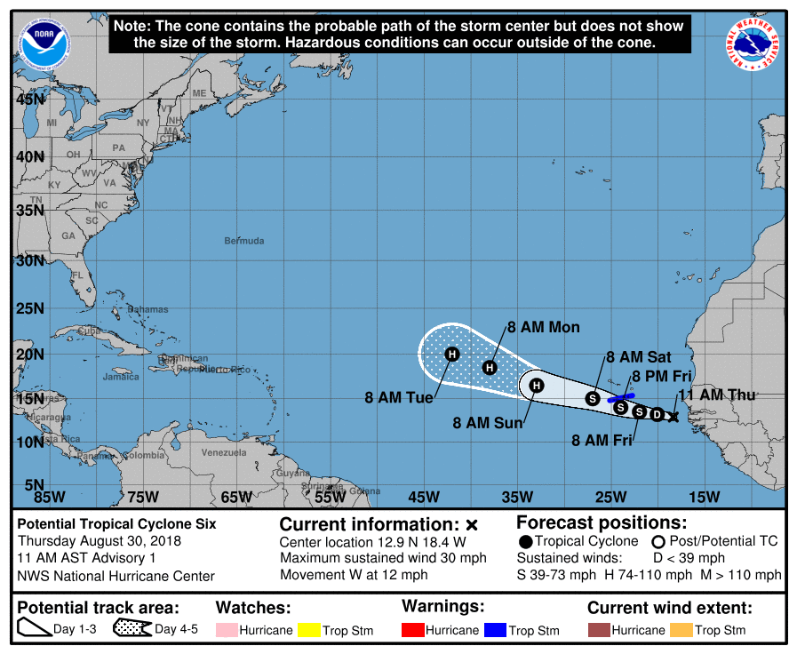
POST TROPICAL CYCLONE SIX HAS FORMED OUT IN THE EASTERN ATLANTIC
The first public advisory was issued for PTC-6 at 11:00 AM AST and will be bringing tropical storm conditions to the southern parts of the Cabo Verde Islands tomorrow. Santiago, Fogo, and Brava have been placed under a tropical Storm Warning. The NHC is giving PTC-6 an 80% chance of forming into a depression or storm within the next 48 hours. While it is still way out in the eastern Atlantic, we’ll have to watch and see where this potential hurricane heads. Currently, motion is to the west at 12 MPH. The NHC has the track heading west-northwest and strengthening into a hurricane by Sunday morning.
The rest of the Atlantic Ocean, Gulf of Mexico, and the Caribbean Sea are free of any points of interest, but we are very close to the peak of our hurricane season. We have to watch for any development very closely, and signs are leading to the action to start picking up.
ON THIS DAY IN WEATHER HISTORY
1776 – General Washington took advantage of a heavy fog to evacuate Long Island after a defeat. Adverse winds kept the British fleet from intervening.
1839 – A hurricane moved from Cape Hatteras NC to offshore New England. An unusual feature of the hurricane was the snow it helped produce, which whitened the Catskill Mountains of New York State. Considerable snow was also reported at Salem NY.
BEACH FORECAST CENTER
Get the latest weather and rip current forecasts for the beaches from Fort Morgan to Panama City on our Beach Forecast Center page. There, you can select the forecast of the region that you are interested in.
WE’RE HAVING A RECORD-BREAKING YEAR… ADVERTISE WITH US TODAY!
Don’t miss out! We have enjoyed over 13.5 MILLION page views on AlabamaWx.com since the start of 2018. We can customize a creative, flexible and affordable package that will suit your organization’s needs. Contact Bill Murray at (205) 687-0782.
E-FORECAST
Get the AlabamaWx Weather Blog’s Seven-Day Forecast delivered directly to your inbox by email twice daily. It is the most detailed weather forecast available in Central Alabama. Subscribe here… It’s free!
WEATHERBRAINS
This week’s show was live from the National Weather Association Annual Meeting with a plethora of interesting guests stopping by the broadcast table. This is the show all about weather featuring many familiar voices, including the meteorologists at ABC 33/40. You can find the show at WeatherBrains.com or on iTunes, Stitcher, or Spotify.
Category: ALL POSTS
About the Author (Author Profile)
Scott Martin is an operational meteorologist, professional graphic artist, musician, husband, and father. Not only is Scott a member of the National Weather Association, but he is also the Central Alabama Chapter of the NWA president. Scott is also the co-founder of Racecast Weather, which provides forecasts for many racing series across the USA. He also supplies forecasts for the BassMaster Elite Series events including the BassMaster Classic.Subscribe
If you enjoyed this article, subscribe to receive more just like it.


