Tropical Mischief: Impacts of 91L Along the Gulf Coast
Today is the anniversary of Hurricane Elena, which affected the Gulf Coast on this date in 1985.
We are tracking a tropical wave over the Bahamas this morning that will move into the Gulf of Mexico tonight and progress northwestward around a strong ridge of high pressure over the eastern United States. There is good agreement among the modes that a tropical depression will form tomorrow and move toward southeastern Louisiana coast.
The deterministic European predicts landfall near Grand Isle, LA around midnight Tuesday night. The previous run of the Euro had a much stronger storm or even hurricane hitting just south of New Orleans late Tuesday night.
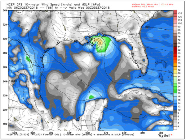
The GFS has a 50 mph Tropical Storm hitting the Louisiana/Mississippi border east of New Orleans late Tuesday night.
The Canadian is a little further west with landfall on the Central Louisiana coast.
Conditions are not favorable for development now over the eastern Gulf with fairly strong wind shear, but hat shear is forecast to decrease later today.
Water temperatures are warm along the projected path, running 29C-30C, which is potent fuel. The system will be moving along at a pretty good clip, 10-15 mph, so it won’t have a lot of time to develop, and the chance it will become a hurricane is small.
WIND IMPACTS:
Sustained winds of 30-40 mph will affect areas from Morgan City to Mobile Bay starting Tuesday afternoon. Winds could gust to 40-50 mph from coastal Louisiana across Lake Ponchartrain, the Mississippi Coast to near Mobile Bay. Gusts of 40-45 mph will move up into southern Mississippi on Wednesday. By Wednesday morning, winds will be gusting over 20 mph at times across much of Central and South Alabama.
HEAVY RAIN IMPACTS:
Showers and storms associated with the storm will begin impacting Coastal Northwest Florida and Alabama on Tuesday, spreading up into South Alabama. Heavy rain will overspread areas from Pensacola to Southeast Louisiana late Tuesday through Wednesday.
RAINFALL TOTALS:
Amounts of 5-10 inches will impact areas from Mobile to Morgan City, with isolated amounts of 10-15 inches from New Orleans to Natchez along the right side of the center’s track. This will cause flooding of course.
RIP CURRENTS:
The rip current threat will become extremely high along the beaches of Alabama and Northwest Florida Tuesday and Wednesday. It is already high for today and Monday. Seas will build to 6-10 feet along the Alabama/Northwest Florida Coast by Tuesday.
COASTAL FLOODING:
Above normal tides and strong onshore flow will lead to coastal flooding starting late Monday for the Alabama and Northwest Florida Coast. Coastal flood advisories are already in effect for coastal Southeast Louisiana and Mississippi.
Category: Alabama's Weather, ALL POSTS, Tropical


