Gordon Making Final Approach To The Gulf Coast


With the current strength and forecast track of Gordon, tropical storm conditions will continue to move onshore from southeast Louisiana to near the Alabama/Florida state line. Maximum sustained winds are still at 70 MPH with gusts up to 85 MPH possible and movement continues to be rather quick to the northwest at 14 MPH. At this point, the center is located 70 miles south of Mobile and 75 miles southeast of Biloxi.

A storm surge of 3-5 feet is forecast along and just east of where the center of Gordon makes landfall (from Dauphin Island and Bayou La Batre over to the north side of Lake Borgne, Louisiana), with a storm surge of 1-3 feet is possible east of that from Mobile Bay to near Destin, also along the southeastern Louisiana coast. Along with the storm surge, life-threatening rip currents will be likely all along the central Gulf Coast from now through the whole day on Wednesday.
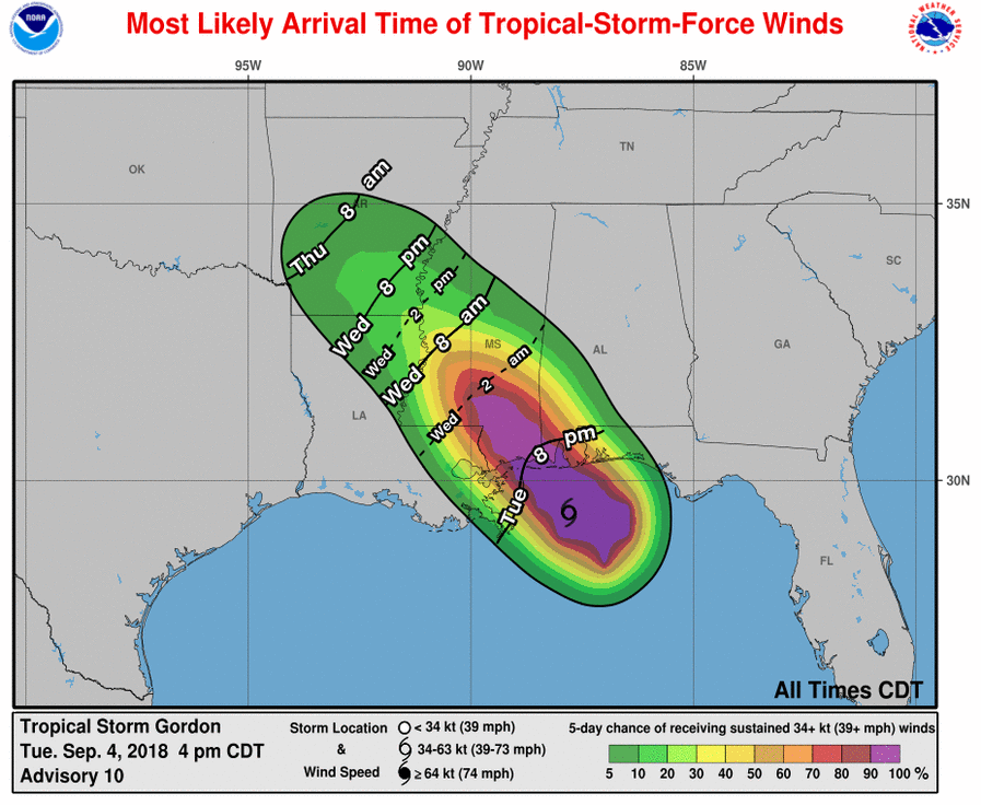
At this point, winds will likely be sustained at 70 MPH with gusts up to 85 MPH possible at times closest to the center of Gordon’s circulation, while tropical storm force winds (39-74 MPH) will be felt up to 80 miles out from the center.

A Slight Risk of severe weather has been defined for extreme southwestern Alabama, a good portion of the Florida Panhandle, and the extreme southeastern corner of Mississippi, while immediately surrounding that area and stretching up more into southeastern Mississippi and southern Alabama is defined in a Marginal Risk. A Tornado Watch was just issued for Mobile and Baldwin counties until 4:00 AM CT. A few tornadoes are possible through tonight to the north and east of the center for the remainder of tonight and through the overnight and early morning hours on Wednesday, while the larger threat will be from damaging wind gusts from Gordon.

We do note that the Marginal Risk of severe weather on the day 2 outlook includes much of the western part of Central and South Alabama, mainly for brief damaging wind gusts and an isolated spin-up tornado or two.
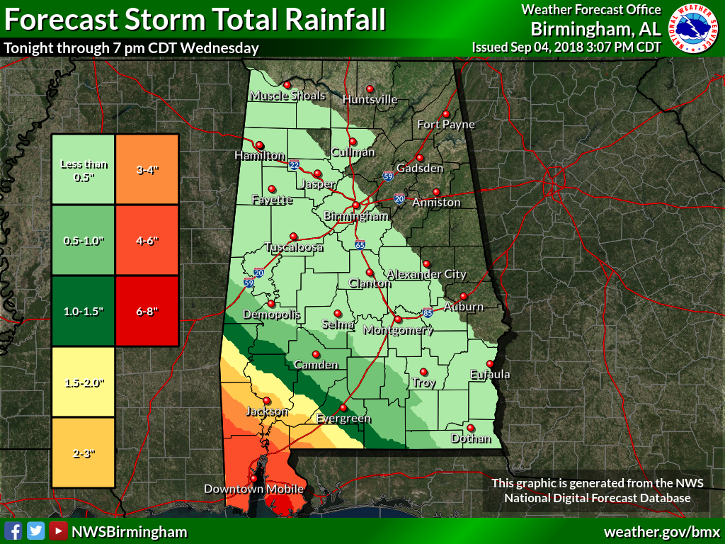
While rainfall amounts through 7:00 PM Wednesday will not be all that impressive across most of Central Alabama, we could see 6-8 inches across the Gulf Coast and up into the southern parts of Mobile and Baldwin counties, with 2-5 inches just north of that. The extreme southwestern counties of Central Alabama could see up to 1.5 inches, while the rest of the area will be less than an inch. A Flash Flood Watch is up for Washington, Escambia, Mobile, and Baldwin counties through Wednesday evening.
We’ll keep you posted throughout the evening and into the overnight hours with any updates and when Gordon makes landfall in a few hours. Keep checking back on AlabamaWx.com often.
Category: Alabama's Weather, ALL POSTS
About the Author (Author Profile)
Scott Martin is an operational meteorologist, professional graphic artist, musician, husband, and father. Not only is Scott a member of the National Weather Association, but he is also the Central Alabama Chapter of the NWA president. Scott is also the co-founder of Racecast Weather, which provides forecasts for many racing series across the USA. He also supplies forecasts for the BassMaster Elite Series events including the BassMaster Classic.Subscribe
If you enjoyed this article, subscribe to receive more just like it.


