At Midday: Rather Wet In The West, Mainly Dry In The East

CONDITIONS AT NOON ACROSS CENTRAL ALABAMA
We continue to have mainly cloudy, cooler, and rather wet conditions over the western half of Central Alabama, while the eastern half is seeing very little in the way of rain. Tropical moisture associated with Tropical Depression Gordon continues to rotate around the center, keeping the west side of the area in mainly light to moderate rainfall. There are a few heavier pockets over parts of Tuscaloosa and Sumter counties, but the good news is that there should not be any organized flash flooding threat for anyone in the area.
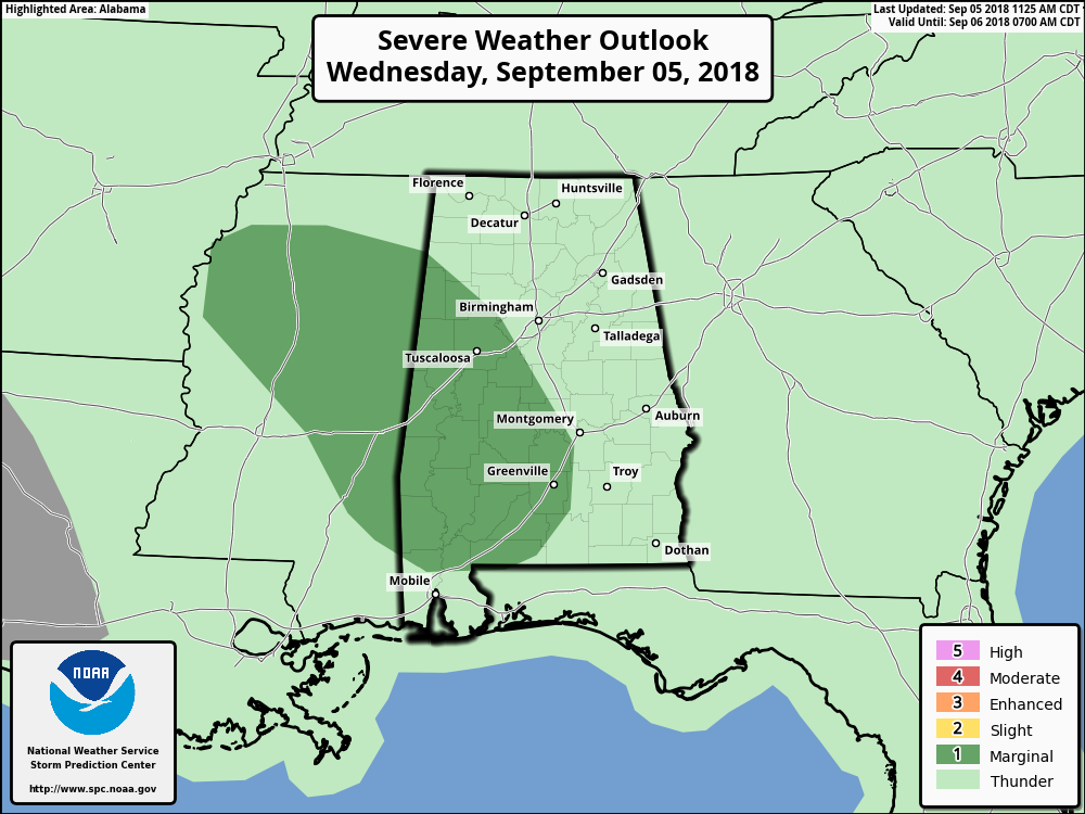
There is a Marginal Risk for severe storms throughout the day today as there is a very, very small risk of a brief spin-up tornado mainly west of I-65. More than likely, a tornado will not occur, but the risk is not an absolute zero either. Just be ready to move to your place of safety in case a tornado warning is issued for your location. Any tornado threat should dissipate completely by sunset as low/mid-level winds continue to weaken and the atmosphere stabilizes due to the loss of daytime heating.
WEATHER FOR THE REST OF YOUR WEDNESDAY
Skies will continue to be mainly cloudy from the wet side of Tropical Depression Gordon, and rainfall is expected to continue for at least through the remainder of the daylight hours for much of the western half of the area. Generally east of I-65, those rainfall chances drop drastically with a few isolated to scattered showers possible, from 70% all of the way down to 20% at the AL/GA state line. Thanks to the cloud cover and rainfall, afternoon highs will only be in the lower to mid-80s.
For tonight and through the overnight and early morning hours on Thursday, rainfall will start to decrease in coverage as Gordon continues to slowly move off to the northwest. A few showers may linger throughout the night on the western side of the area, but chances will be much lower than today’s, around 30-40% west of I-65 and 20% and less east of I-65. Lows will be in the lower to mid-70s.
POTENTIAL RAINFALL THROUGH THIS EVENING
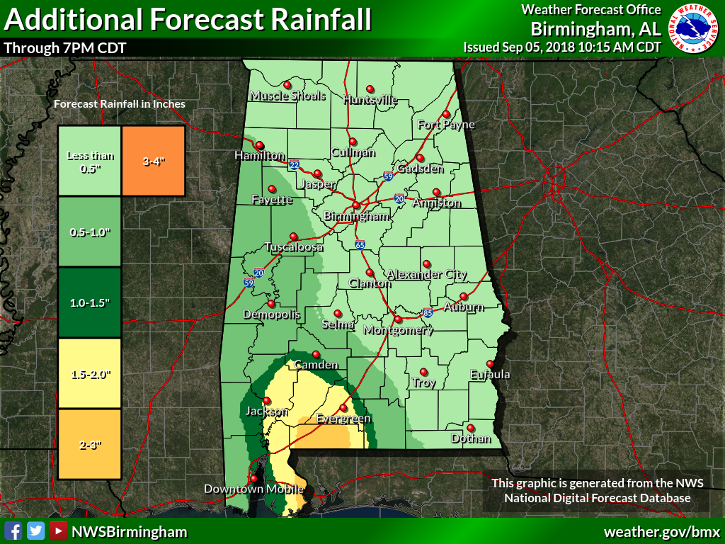
For much of Central Alabama through the remainder of the daytime hours until around 7:00 PM this evening, rainfall totals will be less than 1/2-inch, while some of the western locations could see up to 1-inch totals. The heavier rains will stay generally in the southwestern parts of the state where totals could be as high as 2-3 inches.
TROPICS REMAIN VERY ACTIVE
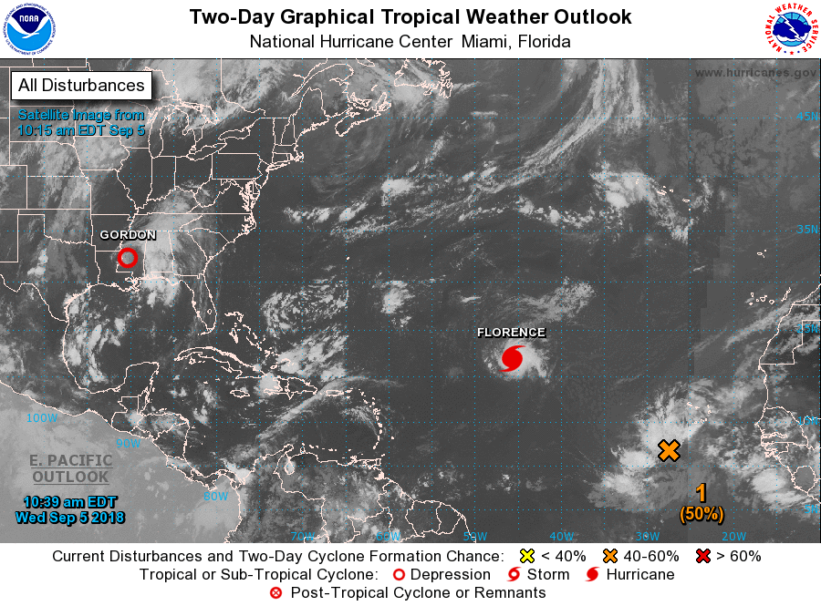
As Gordon continues to move to the northwest away from the area, our eyes now shift back out to the open Atlantic as we now have our first major hurricane of the season. Florence is now rated as a category 3 hurricane with maximum sustained winds at 125 MPH. The forecast track has Florence recurving away from land well before approaching the US mainland, but a few members of the latest ensembles have it making landfall on the east coast. The European model actually has Florence coming onshore as a hurricane on Thursday of next week. This is just one model run and not a forecast. We’ll keep our eyes on her and let you know what to expect as she continues to move west-northwestward across the Atlantic.
Our next system that is located to the south-southwest of the Cabo Verde Islands should become Helene within the next few days. It is currently well to far out to get any specific details on how close it will get to the US Mainland, but it will be moving to the west-northwest across the tropical Atlantic.
Another tropical wave will be emerging off of the African coast in a few days, but it will take a while for it to develop into anything. This just goes to show that we are just now hitting the peak of the season. May stay busy out there for a while.
LOOK BEFORE YOU LOCK
Never leave children, disabled or elderly adults, or pets in parked vehicles. Studies have shown that the temperature inside a parked vehicle can rapidly rise to a dangerous level for children, pets, and even adults. Leaving the windows slightly open does not significantly decrease the heating rate. The effects can be more severe on children because their bodies have not developed the ability to efficiently regulate internal temperature. Heat-related deaths are preventable, so look before you lock.
ON THIS DAY IN WEATHER HISTORY
1925 – The temperature at Centerville, AL, soars to 112 degrees to establish a state record. Every reporting station in Alabama was 100 degrees or above that afternoon.
BEACH FORECAST CENTER
Get the latest weather and rip current forecasts for the beaches from Fort Morgan to Panama City on our Beach Forecast Center page. There, you can select the forecast of the region that you are interested in.
WE’RE HAVING A RECORD-BREAKING YEAR… ADVERTISE WITH US TODAY!
Don’t miss out! We have enjoyed over 14 million page views on AlabamaWx.com since the start of 2018. We can customize a creative, flexible and affordable package that will suit your organization’s needs. Contact Bill Murray at (205) 687-0782.
E-FORECAST
Get the AlabamaWx Weather Blog’s Seven-Day Forecast delivered directly to your inbox by email twice daily. It is the most detailed weather forecast available in Central Alabama. Subscribe here… It’s free!
WEATHERBRAINS:
Don’t forget you can listen to our weekly 90 minute netcast anytime on the web at WeatherBrains.com or on iTunes, Stitcher, or Spotify. This is the show all about weather featuring many familiar voices, including the meteorologists at ABC 33/40.
Category: Alabama's Weather, ALL POSTS
About the Author (Author Profile)
Scott Martin is an operational meteorologist, professional graphic artist, musician, husband, and father. Not only is Scott a member of the National Weather Association, but he is also the Central Alabama Chapter of the NWA president. Scott is also the co-founder of Racecast Weather, which provides forecasts for many racing series across the USA. He also supplies forecasts for the BassMaster Elite Series events including the BassMaster Classic.Subscribe
If you enjoyed this article, subscribe to receive more just like it.


