A Quick Check On Our Weather At Midday… Plus The Latest on Florence
CONDITIONS AT 12:15 PM
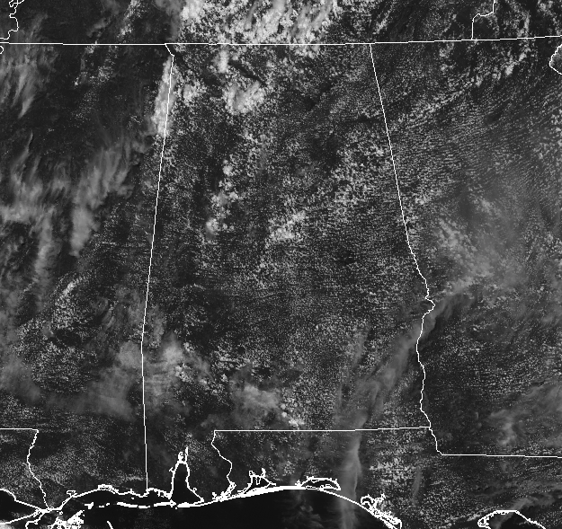
Skies are mostly clear across Central Alabama at Midday with only a few isolated showers showing up over the western half of the area. Shower activity is more pronounced over the north and northwestern parts of the state, with a few showers showing up over the extreme western parts of Marion County. All of these are drifting ever so slowly to the west. Temperatures are in the upper 80s to the lower 90s with Uniontown being the hot spot at 93 degrees. Birmingham was sitting at 88 degrees.
WEATHER FOR THE REST OF YOUR THURSDAY
Skies will become partly to mostly cloudy later in the afternoon and we’ll have a chance of scattered showers and thunderstorms across Central Alabama for the afternoon and the early evening. Afternoon highs will be up in the upper 80s to the lower 90s, with the chance of rain for any one location around 40%. Those rain chances will start to diminish throughout much of the area after sunset with all rain done by midnight. Overnight lows will be in the upper 60s to the mid-70s with skies becoming mostly clear. Some patchy dense fog may develop in areas where rainfall occurred during the evening.
DRY FOR MOST ON YOUR FRIDAY
Skies will be mostly sunny for the most part of the day as subsiding air spooling into the state from Hurricane Florence will keep the eastern half of Central Alabama dry. For the western half of the area, there will be a small chance of a few isolated showers or storms during the afternoon hours, around 20%. Afternoon highs will be in the lower to mid-90s throughout the area. Any shower chances should die off before kickoff of most high school football games, but a few locations in the west may have a very small chance of a shower during the first quarter. Temperatures will start off in the mid-80s to just at 90 degrees at kickoff and dropping into the mid-70s to the lower 80s by the final whistle. Overnight lows will be in the upper 60s to the lower 70s.

THE LATEST ON FLORENCE
As of 11:00 am CT, Hurricane Florence continues to make her approach to the Carolina coastline. Tropical-storm-force winds are already spreading across the outer banks and the southeastern parts of North Carolina, and a Tornado Watch is in effect for the eastern parts of North Carolina including the coastal waters.

Current maximum sustained winds are at 105 MPH with a minimum central pressure of 955 MB (28.20 inches). The Cape Lookout reporting station just recently reported sustained winds at 55 MPH with gusts up to 70 MPH, and the center was still 130 miles east-southeast of Wilmington. Movement at this point is to the northwest at 10 MPH, but that is expected to slow throughout the day.
Some strengthening may occur during the day today but should stay below major hurricane status. Once the center makes it near the coastline, frictional forces from the western half of the storm will begin to weaken the winds and should be a strong category 1 or weak category 2 hurricane when making landfall.

Even with the winds weakening, the flooding threat will continue to be the biggest story as some places could get up to 20-30 inches of rain throughout the event. Flooding threat will be highest for the eastern half of South Carolina, North Carolina, and Virginia. Here are the key messages…
A life-threatening storm surge is now highly likely along portions of the coastlines of South Carolina and North Carolina. The greatest storm surge inundation is expected between Cape Fear and Cape Hatteras, including the Neuse and Pamlico Rivers and western Pamlico Sound.
Life-threatening, catastrophic flash flooding and prolonged significant river flooding are likely over portions of the Carolinas and the southern and central Appalachians through early next week, as Florence is expected to slow down as it approaches the coast and moves inland.
Damaging hurricane-force winds are likely along portions of the coasts of South Carolina and North Carolina as soon as this evening, and a Hurricane Warning is in effect. Strong winds could also spread inland into portions of the Carolinas.
Large swells affecting Bermuda, portions of the U.S. East Coast, and the northwestern and central Bahamas will continue this week, resulting in life-threatening surf and rip currents.
KEEPING OUR EYES ON ISAAC
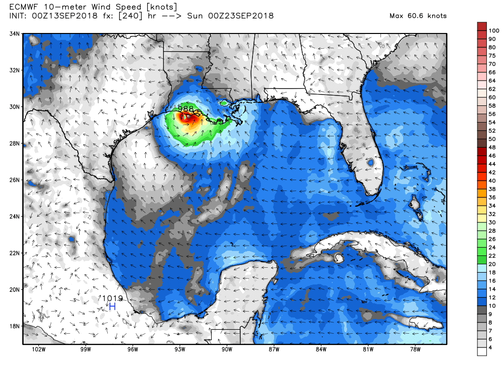
While Tropical Storm Isaac will be moving through less conducive conditions throughout the next several days, there is a possibility that a weaker Isaac may survive and move west-northwest into the southern Gulf of Mexico. We do note that the latest run of the European model shows Isaac surviving and strengthening back to a strong tropical storm or weak category 1 hurricane by Sunday 9/23 and making landfall on the Louisiana coast. This is just one model run and not a forecast. This just shows us that we need to keep our eyes on Isaac throughout the next week or so.
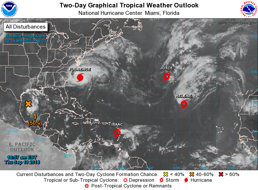
THE REST OF THE BUSY TROPICS
Tropical Storm Helene is on a weakening trend and is moving to the north at 14 MPH well away from any major land mass at the moment. She will continue to curve to the northeast and may cross over the Azores on Saturday.
Subtropical Storm Joyce will not be a threat to any land mass as she will move southwest today very slowly and eventually curving back around to the northeast by Friday night and over the open Atlantic.
For the disturbance that is over the Gulf of Mexico, it’s a race of strengthening into a depression before it makes landfall on the western Gulf Coast. NHC is only giving it a 50% chance for development, but no matter if development occurs, heavy rain and gusty winds will be likely over northeastern parts of Mexico and the southern parts of Texas and Louisiana on Friday and Saturday.
Another area of interest will be developing this weekend or early next week near Bermuda. Some development is expected after formation next week as it drifts westward, but too early for exact details at this point.
Category: Alabama's Weather, ALL POSTS
About the Author (Author Profile)
Scott Martin is an operational meteorologist, professional graphic artist, musician, husband, and father. Not only is Scott a member of the National Weather Association, but he is also the Central Alabama Chapter of the NWA president. Scott is also the co-founder of Racecast Weather, which provides forecasts for many racing series across the USA. He also supplies forecasts for the BassMaster Elite Series events including the BassMaster Classic.Subscribe
If you enjoyed this article, subscribe to receive more just like it.


