Much Quieter On Radar At Midday Today
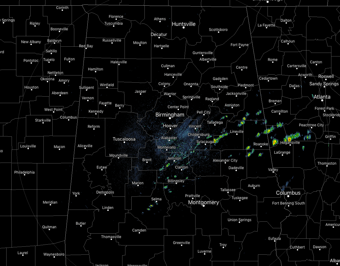
As we are approaching the noon hour on this last Friday of September, we still have a significant amount of cloud cover across Central Alabama with only a few peeks of sun. The best news is that the radar is a lot more quiet today than we have seen for the past few days. There are a few smaller showers dotting the radar across the eastern portions of the area just behind the cold front, all of which is moving off to the east-northeast.
Speaking of the cold front, it is currently draped across the southeastern portions of Central Alabama, stretching from near Huguley (Chambers Co.) down to just north of Ansley (Pike Co.) before exiting into the South Alabama. With the cooler and drier air mixed with the cloud cover, temperatures are in the upper 60s to the upper 70s for much of the area, with lower 80s showing up in the extreme southern portions of the area. Birmingham was at 76 degrees while the cool spot was Haleyville at 69 degrees. Troy and Unionville were tied as the warm spots at 81 degrees.

As you can see by the graphic above, much of the rainfall will be located in the southern half of the state today and this evening, especially south of the front and just a few miles north of the front. The rest of Central Alabama will be dry with much cooler air across the area. Afternoon highs will be in the mid-70s to the lower 80s throughout the area, with the warmer temperatures south of the front. Rainfall chances will be highest along and south of the I-85 corridor, around 40%. North of that, rainfall chances will drop as you travel north from 30% to less than 10% by the time you reach the I-20 corridor. By the time we reach the late night hours, all rainfall activity should have diminished and we’ll be left with mostly cloudy skies. Lows will dip down into the upper 50s in the north to the lower 70s in the south.
For tonight’s football games, the northern half of the area will be dry with mostly cloudy skies while a very small chance of showers will continue through at least the first half for the southern half. Temperatures will be in the 70s at kickoff and falling into the mid-60s tot he mid-70s by the final whistle.
UPDATE ON THE TROPICS
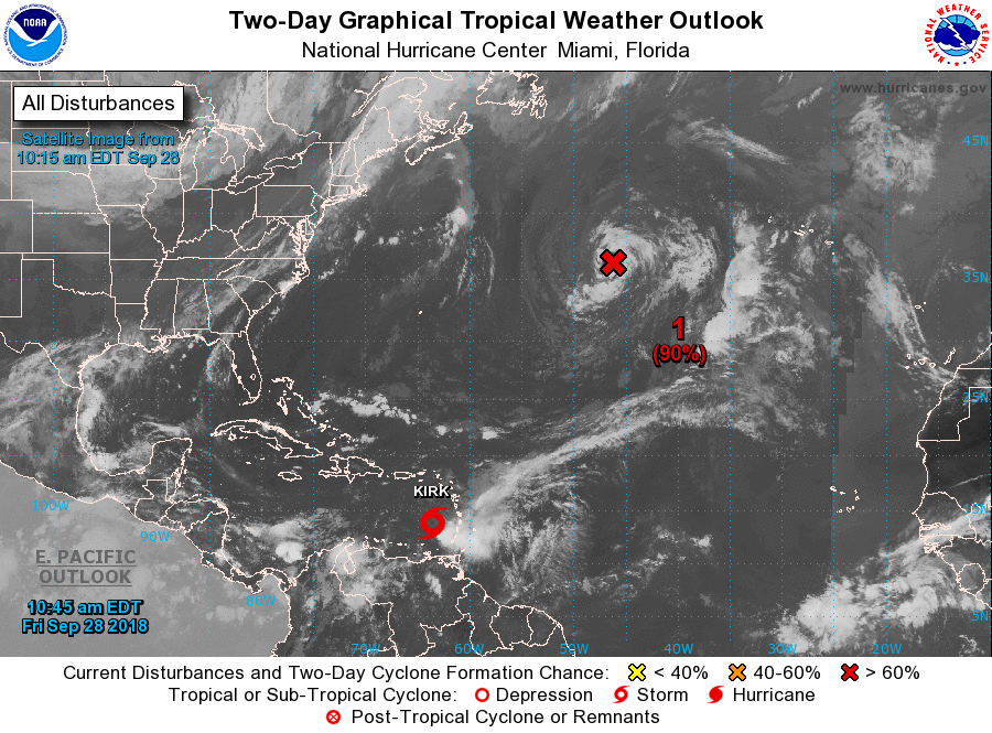
Tropical Storm Kirk is hanging on to dear life as its center of circulation has become exposed from the deep convection and is losing definition. Maximum sustained winds have dropped to 45 MPH as it moves to the west-northwest at 13 MPH. Kirk is expected to dissipate once again within the next 24-36 hours.
The other hotspot on the map is Post-Tropical Cyclone Leslie located several hundred miles west of the Azores. She is expected to become a subtropical storm once again later today or early tomorrow, but is no threat to any landmass at this point.
BEACH FORECAST CENTER
Get the latest weather and rip current forecasts for the beaches from Fort Morgan to Panama City on our Beach Forecast Center page. There, you can select the forecast of the region that you are interested in.
CONNECT ON SOCIAL MEDIA
You can find the AlabamaWx Weather Blog on the major social media networks:
Facebook
Twitter
WE’RE HAVING A RECORD-BREAKING YEAR… ADVERTISE WITH US TODAY!
Don’t miss out! We have enjoyed over 15 million page views on AlabamaWx.com since the start of 2018. We can customize a creative, flexible and affordable package that will suit your organization’s needs. Contact Bill Murray at (205) 687-0782.
E-FORECAST
Get the Alabama Wx Weather Blog’s Seven-Day Forecast delivered directly to your inbox by email twice daily. It is the most detailed weather forecast available in Central Alabama. Subscribe here… It’s free!
WEATHERBRAINS:
Don’t forget you can listen to our weekly 90 minute netcast anytime on the web at WeatherBrains.com or on iTunes, Stitcher, or Spotify. This is the show all about weather featuring many familiar voices, including the meteorologists at ABC 33/40.
ON THIS DAY IN WEATHER HISTORY
1917 – A hurricane hit Pensacola, FL. Winds gusted to 95 mph, and the barometric pressure dipped to 28.50 inches. Winds at Mobile AL gusted to 75 mph.
Category: Alabama's Weather, ALL POSTS
About the Author (Author Profile)
Scott Martin is an operational meteorologist, professional graphic artist, musician, husband, and father. Not only is Scott a member of the National Weather Association, but he is also the Central Alabama Chapter of the NWA president. Scott is also the co-founder of Racecast Weather, which provides forecasts for many racing series across the USA. He also supplies forecasts for the BassMaster Elite Series events including the BassMaster Classic.Subscribe
If you enjoyed this article, subscribe to receive more just like it.


