Warm, Dry Week Ahead for Central Alabama
Saturday was another dry and very warm day across Central Alabama. One lone thunderstorm decided to set up shop over Auburn and caused a lengthy lightning delay at Jordan Hare for the Tiger game, but everyone else was high and dry. High temperatures across Central Alabama were the same at all five major reporting stations: 87F at Birmingham, Tuscaloosa, Anniston, Calera, and Auburn. Five of a kind! Overnight lows this morning have been in the lower 60s across the Tennessee Valley at places like Muscle Shoals and Fort Payne. Central Alabama readings are in the upper 60s and lower 70s.
FOR YOUR SUNDAY: Storms will be isolated at best again across North and Central Alabama this afternoon. Highs will top out in the middle and upper 80s again.
TEMPS ABOVE NORMAL: We will finish the month of September about 6.5 degrees above normal at Birmingham. Alabama and indeed most f the eastern part of the country have been warmer than normal this month.
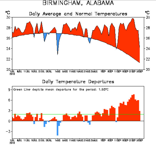
HIGH PRESSURE DOMINATES: We could see a very widely scattered storms on Monday, but by Tuesday, the upper level high pressure ridge should be positioned such that drier air is our main import. This means a deficit in our precipitation. That’s nothing new, as we are running some 7.5 inches below normal over the past 90 days at Birmingham. Highs will be in the upper 80s much of the week ahead. Lows will be in the upper 60s.
GROWING DEFICIT: That rainfall deficit has continued to grow and it will grow further this week. The next meaningful for Alabama won’t come until the end of the long range forecast period, otherwise known as…
…VOODOOLAND: The GFS depicts a frontal system with rain and storms for us by Wednesday, October 10th. We cn only keep our fingers crossed. October is the driest month of the year on average here in Alabama.
ROSA: Hurricane Rosa will make landfall over Baja California tomorrow and move up into the Southwestern United States. Flash flood watches extend from southeastern California across much of Arizona, Nevada and Utah.
SURF’S UP! High surf advisories are in effect for the south facing beaches of Southern California where seas will build to 6-10 feet with local sets to 12 feet through Monday evening.
LESLIE: Leslie became a grown up tropical storm yesterday and is destined to become a hurricane this week as it wanders over the Central Atlantic.
ON THIS DATE IN 1921: Four inches of rain fell on the deserts of southern California as a result of a dying tropical cyclone that cross Baja California and moved into southwestern Arizona. Sound familiar?
WEATHERBRAINS: Former Birmingham TV Met Jay Prater was our guest on WeatherBrains this past week. It was an amazingly fun conversation. You gotta check it out. www.WeatherBrains.com.
Category: Alabama's Weather, ALL POSTS
About the Author (Author Profile)
Bill Murray is the President of The Weather Factory. He is the site's official weather historian and a weekend forecaster. He also anchors the site's severe weather coverage. Bill Murray is the proud holder of National Weather Association Digital Seal #0001 @wxhistorianSubscribe
If you enjoyed this article, subscribe to receive more just like it.


