All Eyes on the Gulf for a Late Season Tropical Storm/Hurricane
Our system in the western Caribbean was officially given tropical depression status at 4 a.m. CDT this morning and it will likely be Tropical Storm Michael this afternoon. It has a good chance to become a hurricane before impacting the Northern Gulf Coast on Wednesday. Lots of details to talk about, so let’s get started.
PLEASANT MORNING: After another hot Saturday across Central Alabama, things are rather pleasant this morning with a beautiful sunrise and readings in the upper 60s for the most part. Temperatures will climb to near 90F today in most spots, likely for the last time this season. There will be a few isolated showers over the northern half of the state this afternoon, with the best chances coming over Northwest Alabama, where they could be a little more concentrated. Lows tonight will be back in the upper 60s.
BIG TROUGH AHEAD: A very deep trough of low pressure is over the western United States this morning. It will be moving eastward over the next 3 days, setting the stage for flooding rains and severe weather across the Central part of the nation and a pattern change for us by next weekend. In the meantime, it will allow our Gulf Tropical Storm/Hurricane to escape out to the north and northeast between it and blocking high pressure that has been over the eastern United States for several days.
OCTOBER HURRICANES…Can be memorable along the Gulf Coast. On October 2, 1893, a hurricane in southeastern Louisiana killed over 2,000 people. Of course, 1995’s Hurricane Opal is etched in the memory of residents along the Northwest Florida coast as well as up into Central Alabama. It caused on the of the greatest power outages in Alabama history. The 1842 Cedar Key Hurricane decimated that island in the Florida Big Bend in 1842. And who could forget Wilma in 2005?
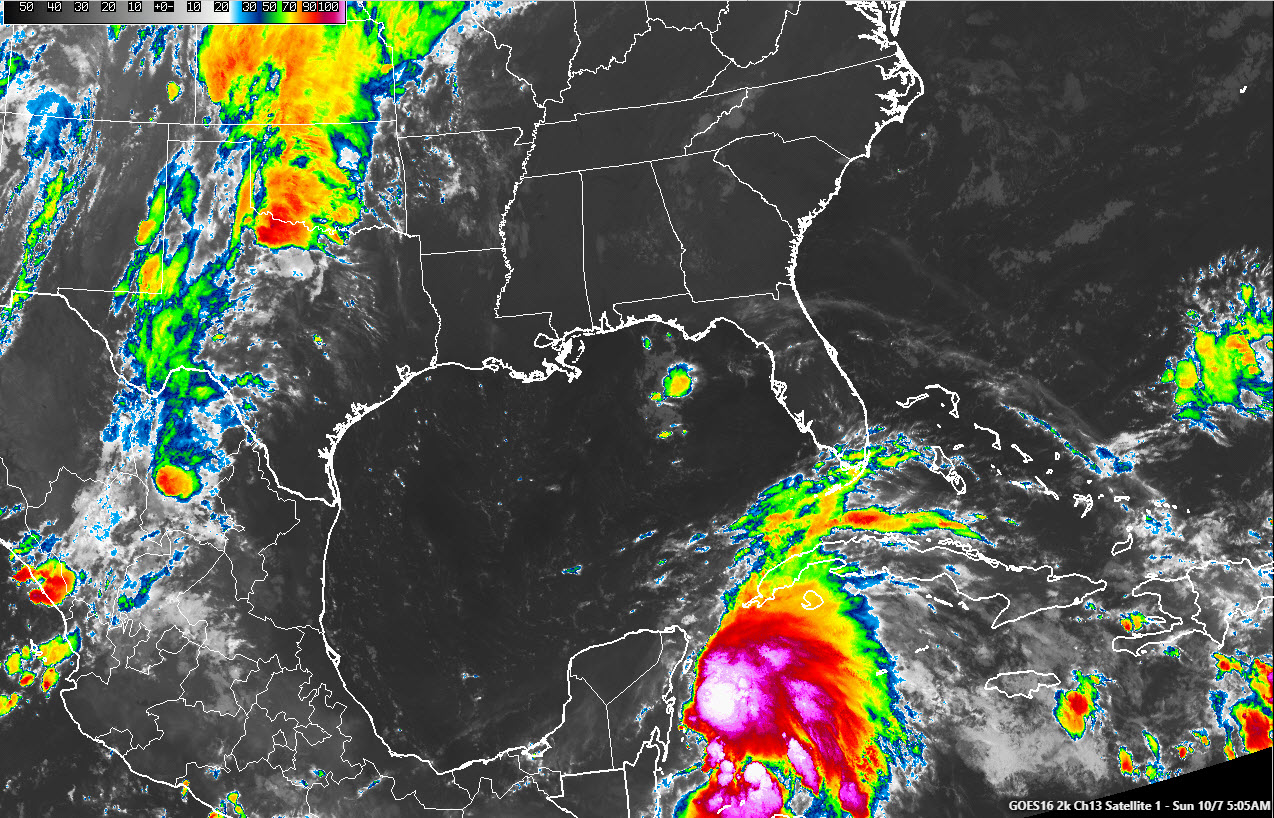
WILL MICHAEL BE MEMORABLE? It is a foregone conclusion now that TD #14 will become Michael, perhaps as soon as this afternoon. The Air Force Reserve Hurricane Hunters are planning three forays into the developing storm today. We will know a lot more after we hear from them. But on satellite this morning, as well as the Belize radar, the convection, and organization of the system is very evident. The simple fact that it is maintaining deep convection despite 20-30 knots of shear is an impressive testament to the very warm and high oceanic heat content of the waters of the western Caribbean. Michael will strengthen slowly as it moves into the Gulf of Mexico on Monday and could become a hurricane by late Tuesday or early Wednesday. It is not expected to become a major hurricane, but wind shear values over the Gulf will be low, so we will keep our eyes open for rapid intensification, especially if it is able to move over any warm water eddies. Michael should be a minimal hurricane when it reaches the northern Gulf Coast on Wednesday.
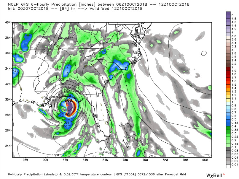
FORECAST TRACK WRINKLES: These is good agreement between the GFS and European that the system will move north and then start turning northeast before landfall. This would place the center inland sometime Wednesday, most likely between Mobile and Panama City. But the forecast cone indicates the center could be as far west as Biloxi and as far east as Cedar Key at landfall. The GFS is faster than the European, with the operational run predicting that landfall will come Wednesday morning between 6 a.m. and noon. The European is a little slower, waiting until later Wednesday to pull the center inland. So watch for timing changes as the forecast evolves.
COASTAL IMPACTS: Rain will begin to increase along the northern Gulf Coast by Tuesday afternoon with the heaviest rain moving onshore after midnight Tuesday night. Very heavy rainfall will impact the coast near and east of the center during the day Wednesday. Rainfall amounts of 5-8 inches will fall near and east of the center, with 2-5 inch amounts to the west of it. Winds will begin picking up Monday along the coast, and it will feel quite breezy. The strongest winds will begin to arrive on the coast after midnight Tuesday night, especially from Fort Walton Beach eastward to Apalachicola. Tides will begin increasing as well by Tuesday and there will be an extreme risk of rip currents. A few tornadoes will be possible as well over coastal areas of Northwest Florida by Tuesday evening.
INLAND EFFECTS: It will begin to feel breezy across inland sections of Alabama by Tuesday afternoon. Winds of 15-25 mph with higher gusts will overspread South and Southeast Alabama early Wednesday, with the strongest winds likely only affecting extreme Southeast Alabama into southwestern Georgia. A few showers will show up Tuesday afternoon, with steadier rain Tuesday night into Wednesday. Areas east of I-65 may see over two inches of rain with areas south of I-85 picking up between 2-5 inches. There could be isolated tornadoes over Southeast Alabama late Tuesday into Wednesday.
LATE WEEK: As Michael accelerates off to the northeast on Thursday, a few showers will remain in the forecast for Central Alabama, especially eastern sections. A cold front will sweep across the state on Thursday, ushering in drier air by Friday and setting the stage for comfortable conditions for high school football Friday night.
WEEKEND SNEAK PEEK: Another front will usher in a reinforcing shot of cooler and drier air on Saturday. It should be mainly dry, although there could be a few showers during the day. Highs over the weekend will be in the 70s, but 60s will be possible by the following Monday and Tuesday, with widespread 40s for lows.
VOODOO TERRITORY: Out at the end of the period, around October 21st, the GFS depicts a stormy look with a surface low over Arkansas.
BEACH FORECAST: Obviously, beach vacations will be impacted for folks from Dauphin Island to St. George Island. But the good news is that the National Shrimp Festival should be fine for next weekend, with the adverse weather departing the Alabama coast by late Wedensday into Thursday. There will be an extreme risk of rip currents this week.
WEATHERBRAINS: Join us Monday night with the guest will be Brian Elbing, an expert on the acoustical signature of tornadoes. Check out the show at www.WeatherBrains.com. Tune in live at live.bigbrainsmedia.com at 8:30 p.m. Monday evening or watch on the James Spann 24×7 weather channel on your local cable system.
ON THIS DATE IN 2008: At its peak, the tropical storm force winds in Marco extended out a miniscule 15 miles, making Marco the smallest tropical cyclone ever in the Atlantic basin.
Category: Alabama's Weather, ALL POSTS
About the Author (Author Profile)
Bill Murray is the President of The Weather Factory. He is the site's official weather historian and a weekend forecaster. He also anchors the site's severe weather coverage. Bill Murray is the proud holder of National Weather Association Digital Seal #0001 @wxhistorianSubscribe
If you enjoyed this article, subscribe to receive more just like it.


