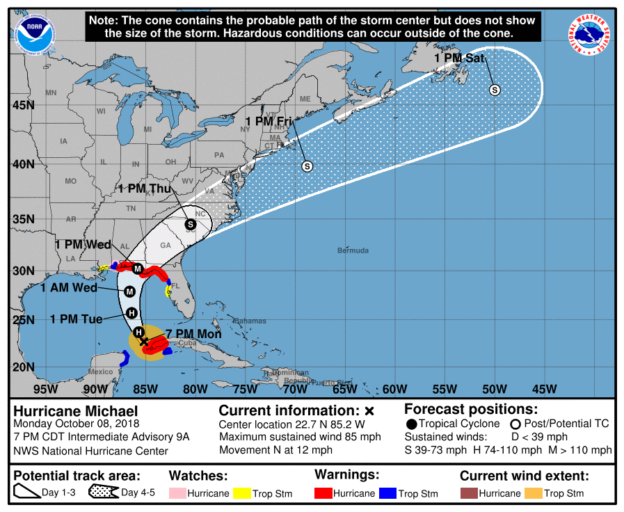
Latest Information On Strengthening Michael
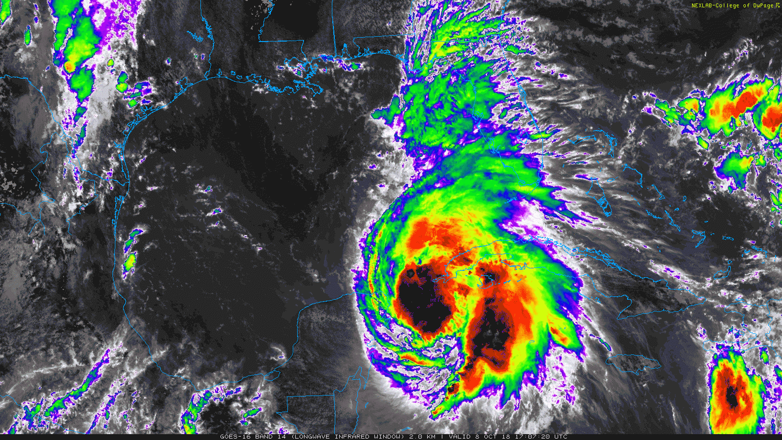
Maximum Sustained Winds: 85 MPH
Movement: N at 12 MPH
Minimum Central Pressure: 970 mb
Location: About 485 miles south of Apalachicola, Florida
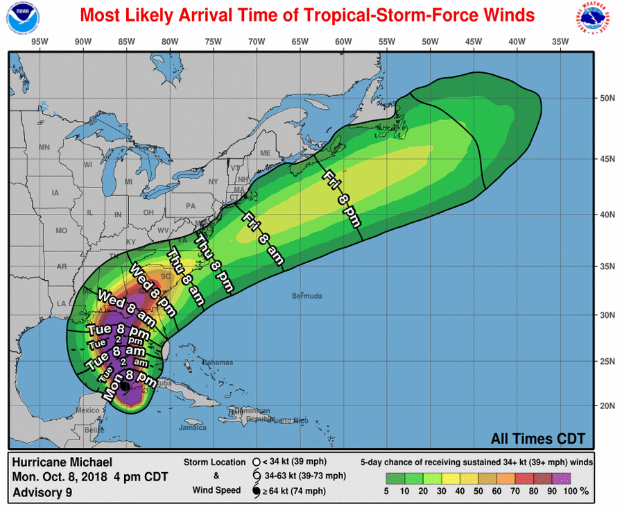
Even though the center of Hurricane Michael is still located in between the western tip of Cuba and the eastern shores of the Yucatan Peninsula, we have already seen rough surf start to affect the Gulf Coasts of Alabama and Florida. Orange Beach and Gulf Shores are currently flying the red flag for dangerous surf and the risk of strong rip currents. The gulf is closed to swimming and wading from Pensacola down to at least Panama City Beach. Flooding has already been reported on the west end of Dauphin Island earlier this afternoon.
Mandatory evacuations have been ordered to start at sunrise on Tuesday morning for Panama City Beach, Panama City, and Lynn Haven. Some people have already started that process. Northbound highways and gas stations have already been full of evacuating residents and vacationers. More evacuations may be ordered very soon.
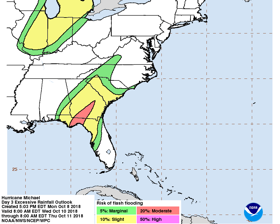
For Central Alabama, the larger impacts will be focused on the southeastern counties of the area, mainly along and east of I-65 and along and south of I-85. We could see rainfall amounts in the 1-3 inch range with the possibility of localized higher amounts. Wind gusts could be as high as 30-45 MPH in this area. We’ll have to continue to watch the changing forecasts as a slight shift in any direction will alter the affects seen in the area. We could see a Tropical Storm Watch issued for those southeastern locations for Wednesday and into Wednesday night.
Weather for the rest of Central Alabama will be much less active. We could see rainfall amounts of 1/2 to 1 inch throughout the area with the exception of the extreme western counties which could receive 1/4 to 1/2 inches within the next 72 hours. While we’ll have breezy conditions, we won’t see any wind gusts as high as the southeastern counties; but I wouldn’t be surprised if we have a few locations get a brief gust or two over 20-25 MPH, especially south of the I-20 corridor.
STORM SURGE
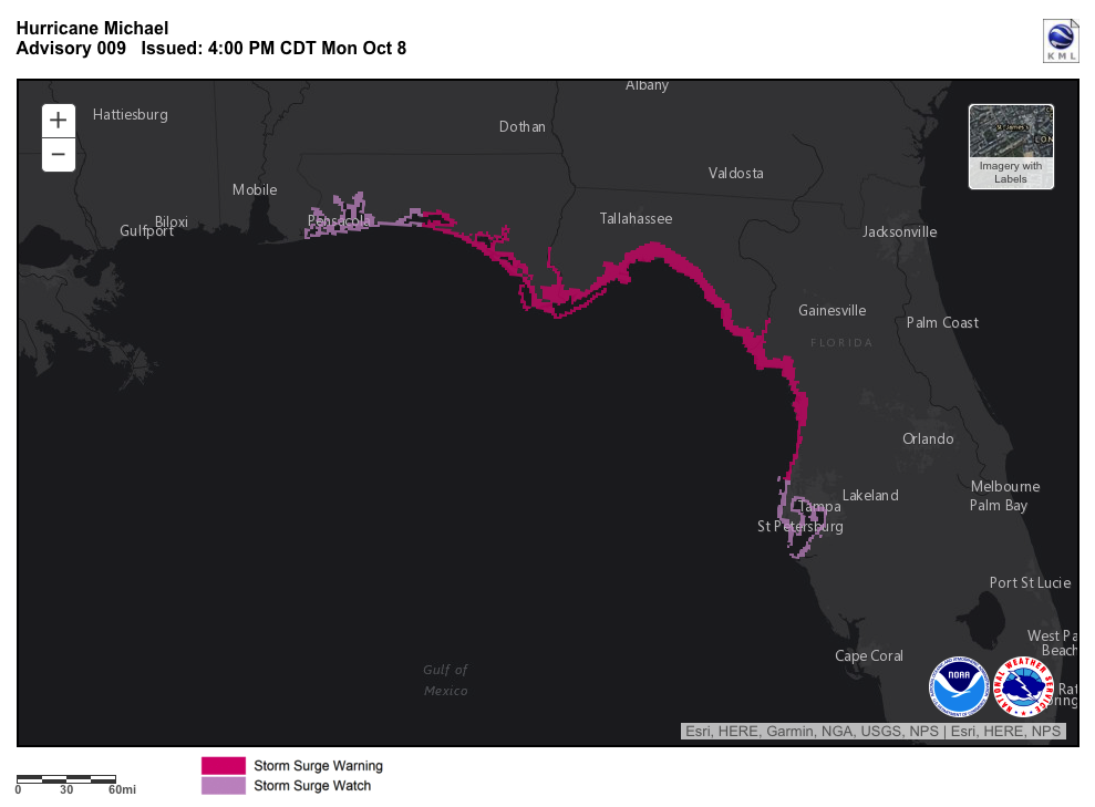
A Storm Surge Warning is in effect from the Okaloosa/Walton County Line, Florida, to the Anclote River, Florida.
A Storm Surge Watch is in effect from the Anclote River, Florida, to Anna Maria Island, Florida (including Tampa Bay). A Storm Surge Watch is alos in effect from the Alabama/Florida border to the Okaloosa/Walton County Line, Florida.
The combination of a dangerous storm surge and the tide will cause normally dry areas near the coast to be flooded by rising waters moving inland from the shoreline. The water has the potential to reach the following heights above ground if peak surge occurs at the time of high tide…
Indian Pass, FL, to Cedar Key, FL: 8-12 ft
Cedar Key, FL, to Crystal River, FL: 6-8 ft
Okaloosa/Walton County Line, FL, to Indian Pass, FL: 5-8 ft
Crystal River, FL to Anclote River, FL: 4-6 ft
Anclote River to Anna Maria Island, FL, including Tampa Bay: 2-4 ft
Alabama/Florida border to Okaloosa/Walton County Line, FL: 2-4 ft
WINDS
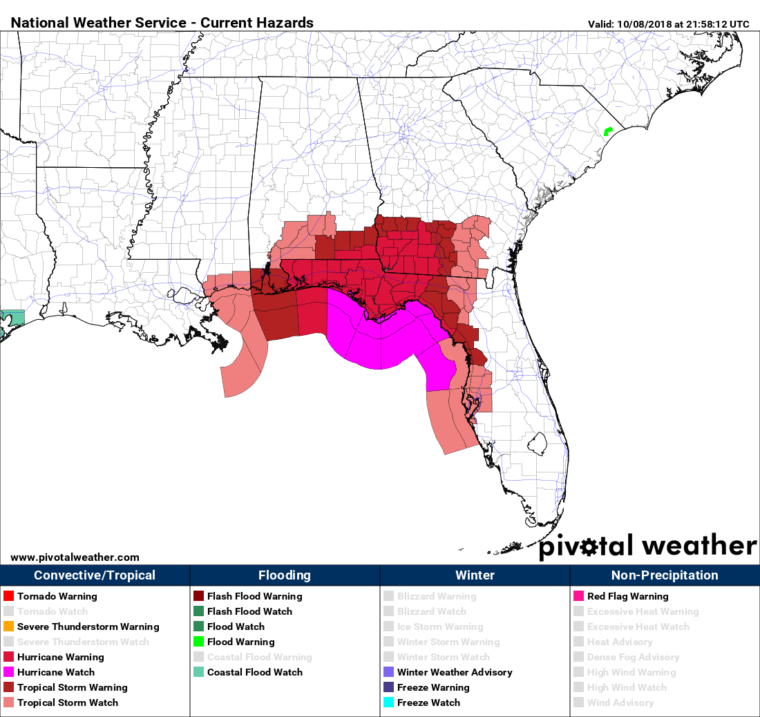
A Hurricane Warning is in effect from the Alabama/Florida border to the Suwannee River, Florida.
A Hurricane Watch is in effect from the Alabama/Florida border to the Mississippi/Alabama border.
A Tropical Storm Warning is in effect from the Alabama/Florida border to the Mississippi/Alabama border, and from the Suwanee River, Florida, to Chassahowitzka, Florida.
A Tropical Storm Watch is in effect from Chassahowitzka to Anna Maria Island, Florida, including Tampa Bay, and from the Mississippi/Alabama border to the Mouth of the Pearl River.
Hurricane conditions are expected within the hurricane warning area along the U.S. Gulf Coast by Wednesday, with tropical storm conditions expected by Tuesday night or early Wednesday. Tropical storm conditions are expected in the tropical storm warning area by Tuesday night or early Wednesday, and are possible within the tropical storm watch area by that time. Hurricane conditions are possible within the hurricane watch area by Wednesday.
RAINFALL
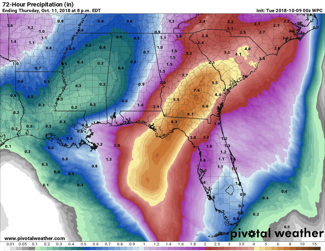
Michael is expected to produce the following rainfall amounts through Friday…
Florida Panhandle and Big Bend across Georgia into South Carolina… 4 to 8 inches, with isolated maximum amounts of 12 inches. This rainfall could lead to life threatening flash floods.
Florida Peninsula, Florida Keys, North Carolina, portions of the Mid-Atlantic States, and the southern New England coast…2 to 4 inches with isolated maximum amounts of 6 inches. This rainfall could lead to life-threatening flash floods.
SURF
While rougher seas and some minor has already started to occur on portions of the Gulf Coast this afternoon, much larger swells are expected to begin affecting the coast of the eastern and northern Gulf of Mexico during the next day or so. These swells are likely to cause life-threatening surf and rip current conditions.
Category: Alabama's Weather, ALL POSTS, Tropical
About the Author (Author Profile)
Scott Martin is an operational meteorologist, professional graphic artist, musician, husband, and father. Not only is Scott a member of the National Weather Association, but he is also the Central Alabama Chapter of the NWA president. Scott is also the co-founder of Racecast Weather, which provides forecasts for many racing series across the USA. He also supplies forecasts for the BassMaster Elite Series events including the BassMaster Classic.Subscribe
If you enjoyed this article, subscribe to receive more just like it.


