The Latest Is In On Hurricane Michael At 1:00 PM
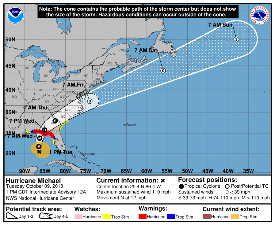
As of the latest update from the National Hurricane Center, maximum sustained winds are still at 110 MPH and movement is still to the north at 12 MPH. The minimum central pressure is at 965mb. The eye is currently located around 335 miles south of Panama City, Florida, and around 310 miles south-southwest of Apalachicola, Florida.
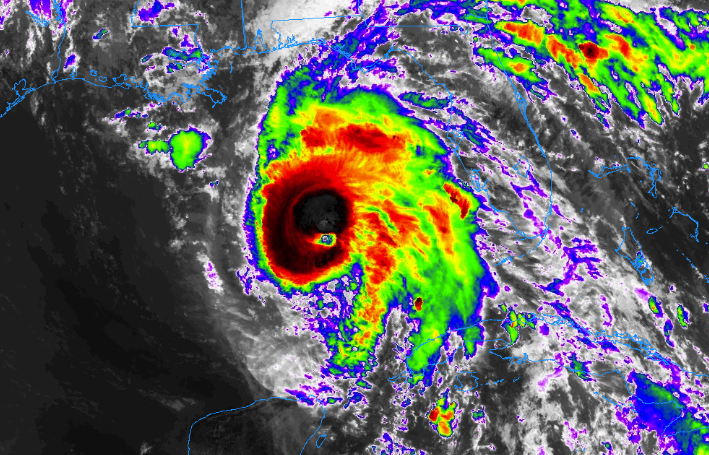
Convection is really starting to wrap around the center again and the outflow has increased, as well. Additional strengthening should occur and Michael is forecast to be a major hurricane at landfall on the Florida Panhandle. Weakening is expected after landfall as Michael moves through the southeastern United States.
Michael should continue moving to the north through the remainder of the day and into tonight before turning to the northeast on Wednesday. The eye of Michael is still expected to make landfall on the Florida Panhandle close to the Big Bend area sometime early on Wednesday afternoon, then it will increase in forward speed and move across the southern parts of Georgia and the Carolinas before exiting off of the Atlantic Coast and moving away from the United States on Friday.
IMPACTS ON CENTRAL ALABAMA
With the latest update from the National Hurricane Center, nothing has changed from what we were thinking earlier this morning. While the showers will be higher in coverage on Wednesday, we don’t expect to see heavy rainfall amounts across much of the area. Most locations will receive around 1/2 inch or less. Winds will be breezy at times across the area, but gusts will be around 20 MPH or less, especially north of the I-85 corridor.
Locations in the area that will receive heavier amounts of rain from Michael will be mainly along and south of I-85 in the southeastern parts of the area (Barbour, Bullock, Pike, and Russell counties). A Flash Flood Watch has been issued for those counties starting at 11:00 am CDT Wednesday and is set to expire at 1:00 am CDT Thursday. At this point, rainfall amounts of 2-4 inches are possible, and if there is any shift in the forecast track to the west by any margin, those totals may increase significantly.
Pike and Barbour counties were included in the Tropical Storm Watch until further notice due to the possibility of tropical storm conditions occurring within the next 48 hours. Wind gusts of 39 MPH and over will be possible in those counties, while higher gusts are possible in the southeastern parts of the state.
IMPACTS ON THE ALABAMA GULF COAST
We are already seeing the affects of Michael across the Alabama Gulf Coast as rough surf and dangerous rip currents. Gulf Shores and Orange Beach are flying the double red flags meaning that the waters are closed to swimming, wading, and surfing. Water levels are already running higher along the coast, as we have already seen minor flooding occurring on the west end of Dauphin Island that started Monday afternoon. Water is now above the seawall on Cotton Bayou.
The good news is that at this point we don’t expect the storm surge to be all that high along the Alabama Gulf Coast as Michael moves closer, the winds will actually push the water out and away from the coast. Until then, we may see minor storm surge of up to 1 foot above dry ground.
Winds will increase throughout the day today and conditions will continue to deteriorate as Michael continues his approach to the Florida Gulf Coast with an expected landfall to occur during the early afternoon hours. The good news is that the Alabama Gulf Coast will be on the left side of the storm, which is usually the less active side of a landfalling hurricane.
Highest wind speeds will occur late tonight through all of the day on Wednesday. Gusts up to 70 MPH will be possible, but sustained winds should be around 55-65 MPH. The tornado threat will be on the eastern side of the storm, so the threat of a brief spin-up tornado for the Alabama Gulf Coast is really-really low.
We’ll continue to keep you posted throughout the day and through the event on the blog. Stay tuned.
Category: Alabama's Weather, ALL POSTS, Tropical
About the Author (Author Profile)
Scott Martin is an operational meteorologist, professional graphic artist, musician, husband, and father. Not only is Scott a member of the National Weather Association, but he is also the Central Alabama Chapter of the NWA president. Scott is also the co-founder of Racecast Weather, which provides forecasts for many racing series across the USA. He also supplies forecasts for the BassMaster Elite Series events including the BassMaster Classic.Subscribe
If you enjoyed this article, subscribe to receive more just like it.


