

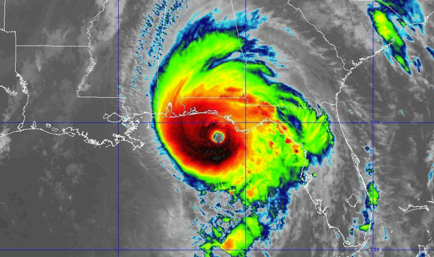
Hurricane Michael As Of 11:00 AM CDT
SUMMARY OF 1100 AM CDT…1600 UTC…INFORMATION
———————————————–
LOCATION…29.6N 85.8W
ABOUT 35 MI…55 KM SW OF MEXICO BEACH FLORIDA
ABOUT 40 MI…65 KM S OF PANAMA CITY FLORIDA
MAXIMUM SUSTAINED WINDS…150 MPH…240 KM/H
PRESENT MOVEMENT…NNE OR 15 DEGREES AT 14 MPH…22 KM/H
MINIMUM CENTRAL PRESSURE…923 MB…27.26 INCHES
11 AM CDT POSITION UPDATE
CORE OF MICHAEL NEARING THE COAST OF THE FLORIDA PANHANDLE BETWEEN ST. VINCENT ISLAND AND PANAMA CITY
A private weather station on St. George Island, Florida, recently reported a sustained wind of 46 mph (74 km/h) and wind gust of 66 mph (106 km/h). The Apalachicola airport recently reported sustained winds of 45 mph (72 km/h) with a gust of 76 mph (122 km/h).
Water levels continue to rise quickly along the coast of the Florida Panhandle. A National Ocean Service water level station at Apalachicola recently reported nearly 5.5 feet of inundation above ground level.
Power outages across the state of Florida are now up to over 43,000… a big increase from nearly 17,000 without power at 10:00 AM CDT.
About the Author (Author Profile)
Scott Martin is an operational meteorologist, professional graphic artist, musician, husband, and father. Not only is Scott a member of the National Weather Association, but he is also the Central Alabama Chapter of the NWA president. Scott is also the co-founder of Racecast Weather, which provides forecasts for many racing series across the USA. He also supplies forecasts for the BassMaster Elite Series events including the BassMaster Classic.Subscribe
If you enjoyed this article, subscribe to receive more just like it.


