

Happy Halloween… Not Too Bad In Central Alabama At Midday

As of 12:30 PM on this final day of October of 2018, we have mostly sunny skies across much of the area, with the exception of the extreme northern parts where we have a few more clouds and some shower activity in the northwestern parts of the state. No rain in Central Alabama at this point, and temperatures are running in the upper 60s in the north to the lower 80s in the south.
Looks like we will mainly stay dry across all of Central Alabama throughout the rest of the afternoon and into the “Trick Or Treat” hours this evening, but there is a very small chance (less than 20%) of an isolated passing shower over the extreme western locations. Afternoon highs will top out in the upper 70s to the mid-80s. For the late night and the overnight hours, rain chances will start to increase over the western locations, but the main activity looks to hold off until around dawn on Thursday. Overnight lows will be in the 60s.
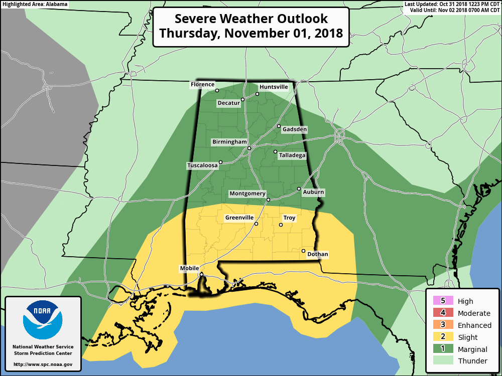
On Thursday, we have a threat of stronger to severe storms across Central Alabama from the early morning hours through the late afternoon. The Storm Prediction Center has the extreme southern locations defined in a Slight Risk for severe storms, while the rest of Central Alabama is defined in a Marginal Risk. The main threat in the slight risk area is isolated damaging thunderstorm wind gusts up to 60 MPH and a couple of brief tornadoes are possible, while the threat is lower in the marginal risk area, but not zero.
A cold front will be moving through the state on Thursday, bringing with it a line of thunderstorms with heavy rainfall, dangerous lightning, and the possibility of damaging wind gusts and a brief spin-up tornado or two. The greatest instability will be over the southern parts of the area (in the slight risk area). Significant Tornado Parameters are not all that impressive, with values maxing out around 1.6 in the southeastern parts of the area just before moving into Georgia after 3:00 pm. Helicity values are higher over the northern half of the area, but there is just enough shear in the southern half for the possibility of a couple of brief spin-up tornadoes.

The above combo image are simulated radar runs from the 12z NAM-3k model showing where the line of storms is projected to be at 5:00 am, 9:00 am, 1:00 pm, and 5:00 pm on Thursday. This is really close to the timing that NWS Birmingham was showing on their graphic… stronger to possible severe storms will affect the western locations during the 6:00 am – 10:00 am timeframe, the central locations in the 9:00 am – 1:00 pm timeframe, and the eastern location in the 12:00 pm – 4:00 pm timeframe.
Have a reliable way of receiving weather alerts throughout the early morning and afternoon hours on Thursday, and make sure you have fresh batteries in your flashlights and NOAA WeatherRadios. I’ll have updates on the blog throughout the day.
Category: Alabama's Weather, ALL POSTS
About the Author (Author Profile)
Scott Martin is an operational meteorologist, professional graphic artist, musician, husband, and father. Not only is Scott a member of the National Weather Association, but he is also the Central Alabama Chapter of the NWA president. Scott is also the co-founder of Racecast Weather, which provides forecasts for many racing series across the USA. He also supplies forecasts for the BassMaster Elite Series events including the BassMaster Classic.Subscribe
If you enjoyed this article, subscribe to receive more just like it.


