Clouds and Showers Not Far Away; Another Look at the Severe Weather Threat for Late Monday and Tuesday
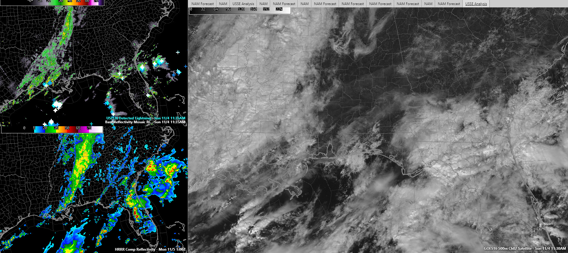
Much of North and central Alabama has had sunny skies all morning, but that is about to change as a strong trough of low pressure moves our way overnight. This is evident on the visible satellite image in the right panel of the graphic shown above.
Showers are ongoing from western Tennessee through much of Mississippi and into Louisiana. There are some storms west of Lafayette, Louisiana. You can see that in the top left panel.
The lower left panel shows the expected radar look at 7 p.m. tonight with lots of showers over areas west of I-59. This activity will spread eastward through the evening hours. There shouldn’t be any lightning with this activity, but I guess you can’t rule out a stray clap of thunder.
Highs this afternoon will be in the 66-71F range, with the warmest numbers across West Central and South Central Alabama in places like Tuscaloosa, Demopolis, and Montgomery. Tonight, lows will fall back into the 50s. Most everyone should get between 0.25-0.50 inches of rain
A significant fall severe weather system will impact Alabama Monday afternoon, Monday night and Tuesday morning as a second strong upper-level trough moves across the area.
Moisture levels will really start to rise tomorrow as the second trough approaches. It will start to feel muggy as we go through the day and southeasterly winds will shift to southerly late in the day and pick up a bit in speed. A few showers will spit and sputter through the day. Despite the showers and mostly cloudy skies all day, highs will top out in the 70s,, ranging from 72F near Hamilton to 79F along US-80. Birmingham should see 75F.
SEVERE WEATHER THREAT: The storms will start to get their act together during the mid-afternoon hours over western Tennessee back into northern Mississippi, eastern Arkansas and Louisiana. Some of those will work their way into Northwest Alabama around dark and others will start forming across the state during the early evening hours. A strong squall line will enter the state around 9 p.m. and push southeastward overnight. There will be a damaging wind threat with the squall line, as well as the threat of a few isolated tornadoes. But it is the storms that form ahead of this squall line that give us the greatest concern. Bulk shear will certainly not be a problem (over 50 knots) and there will be some instability. For the northern half of Alabama, it will be in the 250-1250 joules/KG range, higher to the south of an advancing warm front. There will be decent low-level helicity over central Alabama as well, so tornadoes will be possible as well.
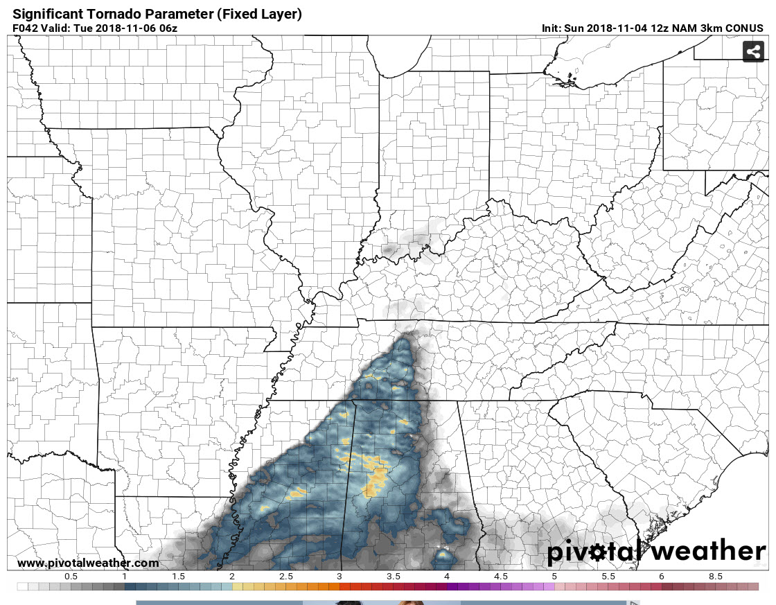
SIgnificant Tornado Parameter off the 3km NAM at midnight Monday night.
GREATEST RISK FOR TORNADOES: The highest possibility of tornadoes seems like it will be over northern Mississippi starting during the early afternoon and pushing eastward into western Alabama with the first activity around 3-6 p.m. A broken line of supercells will affect areas from the Shoals over to Huntsville and down through Marion, Winston, Cullman, Walker, Lamar, Fayette, Pickens, Greene and Tuscaloosa Counties until midnight. This activity should weaken as it moves east of I-59, after midnight. Other storms could cause problems over South Central and East Center Alabama during the evening as well. And then the main line will come through late, bringing a chance of damaging winds and tornadoes with it as well. That line should reach the Shoals after 1 a.m., and Jasper, Tuscaloosa, and Birmingham between 3 and 6 a.m. It will weaken as it moves into East Alabama after 7 a.m.
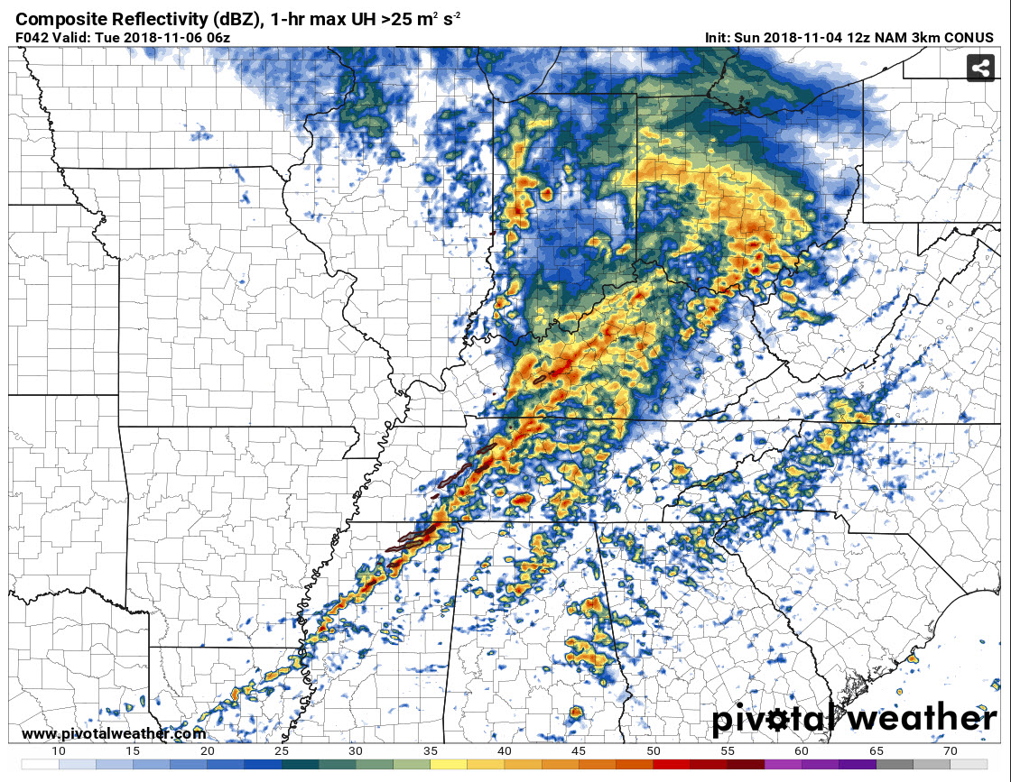
Here is a look at the HRRR composite reflectivity for midnight as well.
SPC RISKS: The Storm Prediction Center has the northwestern quarter of Alabama in an enhanced risk for severe weather on Monday and Monday night (3 out of 5 on the scale). It includes areas north of a line from Geiger to Coker to Sumiton to Hanceville to Arab and Hytop. South of there, a slight risk extends to Butler, Thomaston, Maplesville, Sylacauga, Anniston, and Piedmont. A marginal risk covers much of the rest of the state except for Southeast Alabama.
NEEDLESS TO SAY: All Alabamians should get ready now for this system and monitor the latest forecasts, updates, watches and warnings on Monday afternoon, evening and early Tuesday. Have multiple ways to receive severe weather warnings, on your smartphone, landline or NOAA Weatheradio. Review your personal and work severe weather safety plans and know exactly what to do it a warning is issued for your location. Have your supplies in place, including helmets, hard soled shoes, long sleeved clothes, flashlights, air horns or whistles and a radio. Have your wallet with you. We don’t say all this to scare anyone, but just to help you get you and your network ready for whatever comes our way tomorrow night and Tuesday morning.
AFTER THAT: The front will usher in colder and drier air by Tuesday night, but it will stall near the coast, keeping some rain chances in the forecast, especially as it moves back northward as a warm front. Storms will return by Thursday in the warm sector of another low, and some of them could be strong once again. Another front will transition us to much cooler conditions for the weekend.
Category: Alabama's Weather, ALL POSTS, Severe Weather
About the Author (Author Profile)
Bill Murray is the President of The Weather Factory. He is the site's official weather historian and a weekend forecaster. He also anchors the site's severe weather coverage. Bill Murray is the proud holder of National Weather Association Digital Seal #0001 @wxhistorianSubscribe
If you enjoyed this article, subscribe to receive more just like it.


