At Midday, All Is Quiet For Now… Damaging Winds & Tornadoes Possible Tonight & Into Tuesday
As of 11:00 AM, radar is free of any rainfall across North and Central Alabama, but nearly all of the area is blanketed in cloud cover. There may be a couple of breaks in the clouds, but you won’t see the sun peek through much at all. Temperatures throughout the area are in the mid-50s to the upper 60s from north to south, with the warm spot being Eufaula at 69 degrees. The cool spot is Cullman at 56 degrees, while Birmingham was sitting at 61 degrees.
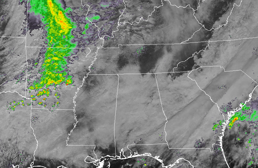
Looking at the combination of the visible satellite and radar composite image, we see that the activity that will be moving into North and Central Alabama later this evening is starting to form up over the Missouri and Arkansas. This system is expected to bring severe storms to parts of Arkansas, Louisiana, Mississippi, Tennessee, and Kentucky throughout the rest of the day today and into the overnight and pre-dawn hours on Tuesday. At this point, there are no severe watches or warnings in effect with this system.
We do have a slight risk of a few isolated to scattered showers and maybe a thunderstorm throughout the afternoon and early evening hours across North and Central Alabama, but none of this activity will be part of the system moving in later tonight, and no strong to severe storms are expected. Afternoon highs will top out in the upper 60s to the upper 70s.
We still continue to hold to our forecast for later tonight through the early morning hours on Tuesday. A strong system will bring a threat of severe thunderstorms to Central Alabama that includes the possibility of damaging winds up to 70 MPH and a few tornadoes. Some of those tornadoes could be significant, long-track in nature.
A squall line will be entering the state right around the midnight hour tonight that will bring the larger threat of damaging winds and maybe a couple brief spin-up tornadoes, but we’ll have the risk of supercells developing out ahead of the line that will have the larger threat of tornadoes. Some hail may be possible, but not likely with this event.
The main window for severe storms continues to hold true at this point, from 9:00 PM tonight through 9:00 AM Tuesday.
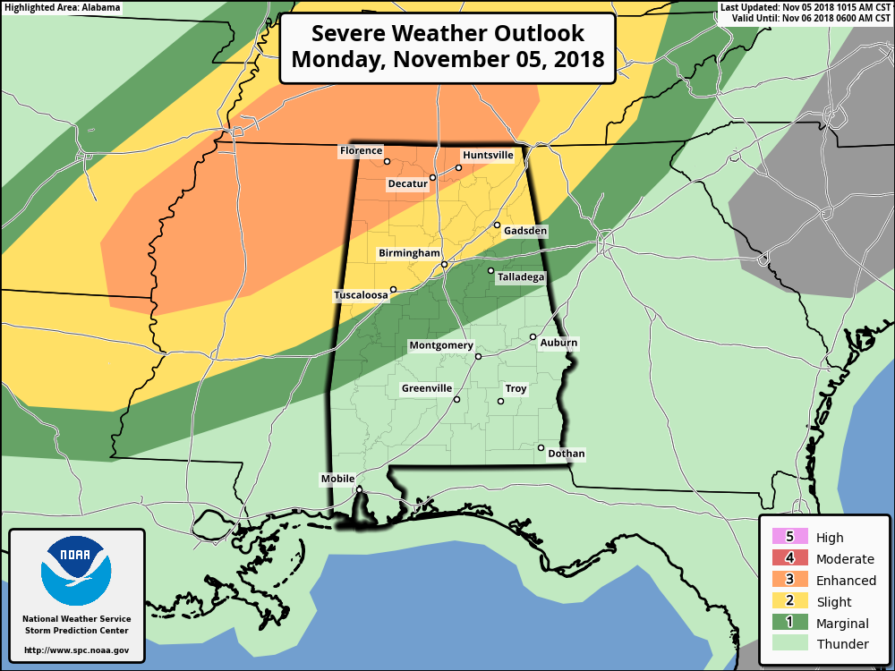
The Storm Prediction Center continues an Enhanced Risk (level 3 of 5) for locations north of a line from Sulligent to Haleyville to Huntsville. A Slight Risk continues for locations extending down to York, Greensboro, Hoover, Glencoe, and Centre. A Marginal Risk continues for locations as far south as Jackson, Greenville, and Auburn.
Please remember… Just because you are not located in the Enhanced or Slight Risk does not mean you are in the clear. You can still have damaging winds and tornadoes, but the chance for these are lower. Still keep your plan ready to go. If your location goes under a warning, know what to do.
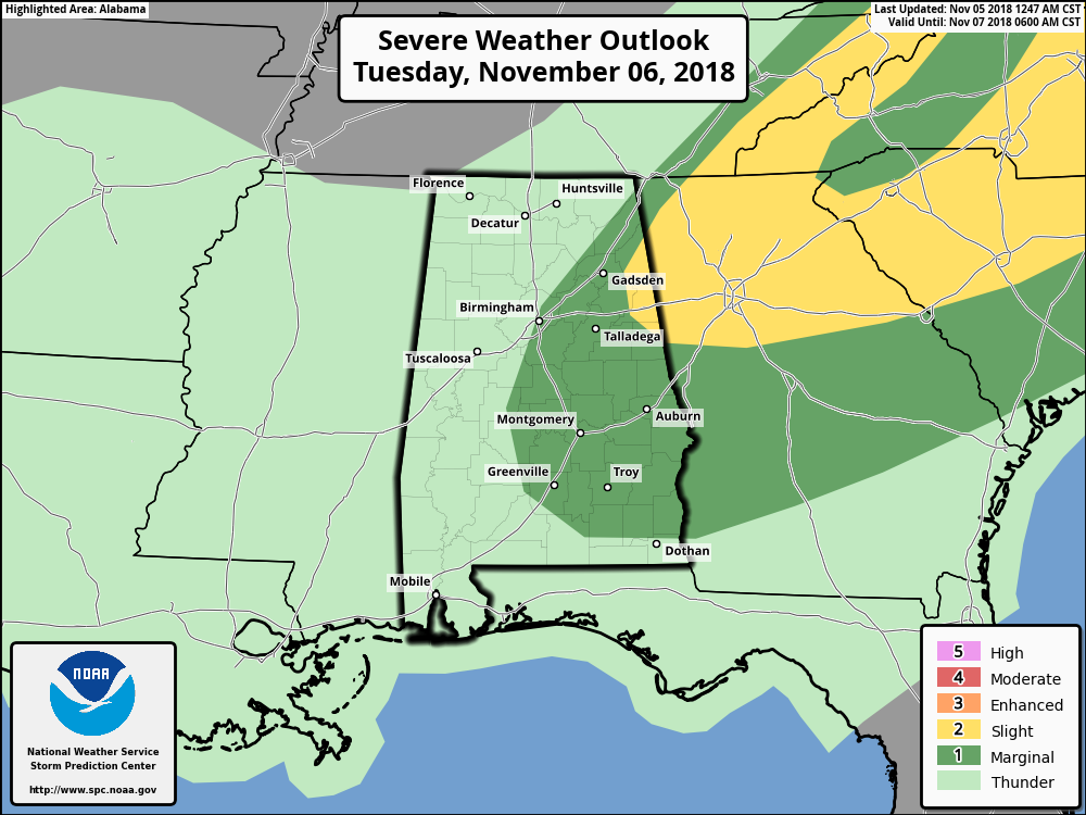
The SPC continues a Slight Risk for Tuesday morning for a small portion of northeast Alabama, with a Marginal Risk for much of the rest of the eastern half of the state.
The latest run of the HRRR model shows that the severe parameters are there during the overnight hours and into the pre-dawn hours on Tuesday. Most Unstable CAPE values are projected to be in the 1,000-1,800 J/kg range with Storm Relative Helicity values more than sufficient to support rotating updrafts. The Supercell Composite Parameter shows that supercell thunderstorms will be possible as values are in the 6-12 range across the area, and Significant Tornado Parameter values are topping out in the 2.0-3.0 range.
Showers and thunderstorms will move out of much of the area by the noon hour on Tuesday, and clearing skies will commence throughout the day behind the front. The rest of Election Day across much of North and Central Alabama will be dry with the exception for the extreme southern locations, where a few lingering showers will remain possible through the afternoon hours. Highs will be in the upper 60s to the upper 70s.
Category: Alabama's Weather, ALL POSTS
About the Author (Author Profile)
Scott Martin is an operational meteorologist, professional graphic artist, musician, husband, and father. Not only is Scott a member of the National Weather Association, but he is also the Central Alabama Chapter of the NWA president. Scott is also the co-founder of Racecast Weather, which provides forecasts for many racing series across the USA. He also supplies forecasts for the BassMaster Elite Series events including the BassMaster Classic.Subscribe
If you enjoyed this article, subscribe to receive more just like it.


