First Mesoscale Discussion Issued To Our West… Tornado Watch Imminent
From the Storm Prediction Center…
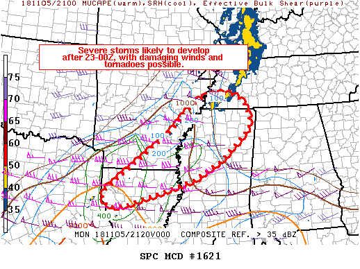
Areas affected…northern Louisiana…eastern Arkansas…northern Mississippi and western Tennessee
Concerning…Severe potential…Watch likely
Valid 052138Z – 052345Z
Probability of Watch Issuance…80 percent
SUMMARY…Storms are expected to increase in coverage mainly after 23-00Z across northern Louisiana and eastern Arkansas, and will gain strength as they develop eastward into northern Mississippi and Tennessee during the evening. Damaging winds and tornadoes will be possible.
DISCUSSION…The air mass across east TX and the lower MS Valley continues to destabilize via both low-level theta-e advection associated with a warm front, and mixing of the boundary layer aided by pockets of heating. As of 21Z, the most unstable air was located over southeast TX, where 70s F dewpoints and strong heating exist.
18Z soundings indicate a substantial midlevel inversion which is limiting instability. This inversion will weaken somewhat this evening as a strong jet max noses into AR, northern MS and western TN, providing cooling aloft.
Currently, scattered convective showers exist near the instability axis over east TX and northwest LA, but they are shallow with no lightning due to the warm midlevel temperatures. However, they are already rotating. Farther north, a band of ascent was evident on radar from the ArkLaTex into central AR, with gradually warming temperatures south of that area.
Over the next several hours, both these areas will likely consolidate into thunderstorms across northern LA and southern AR, and may mature into northern MS and western TN this evening. Shear profiles will continue to increase as the low-level jet intensifies to over 50 kt. Hodographs will strongly favor supercells, potentially tornadic, but storms may eventually transition to a QLCS. Therefore, both damaging winds and tornadoes will be possible. The greatest threat is likely to exist east of the MS river and after 03Z, when lift, shear, and low-level moisture are maximized.
Category: ALL POSTS, Severe Weather
About the Author (Author Profile)
Scott Martin is an operational meteorologist, professional graphic artist, musician, husband, and father. Not only is Scott a member of the National Weather Association, but he is also the Central Alabama Chapter of the NWA president. Scott is also the co-founder of Racecast Weather, which provides forecasts for many racing series across the USA. He also supplies forecasts for the BassMaster Elite Series events including the BassMaster Classic.Subscribe
If you enjoyed this article, subscribe to receive more just like it.


