

A Cold Weekend Ahead With Rain Returning Late Sunday
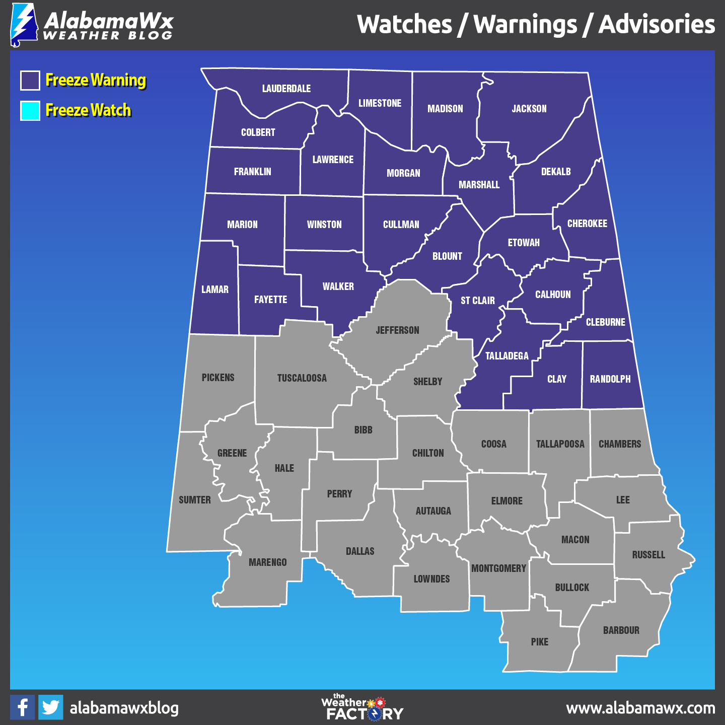
A Freeze Warning continues this morning until 8:00 am for Calhoun, Clay, Cleburne, Randolph, St. Clair, and Talladega counties. All of the North Alabama counties are under the warning until 9:00 am.
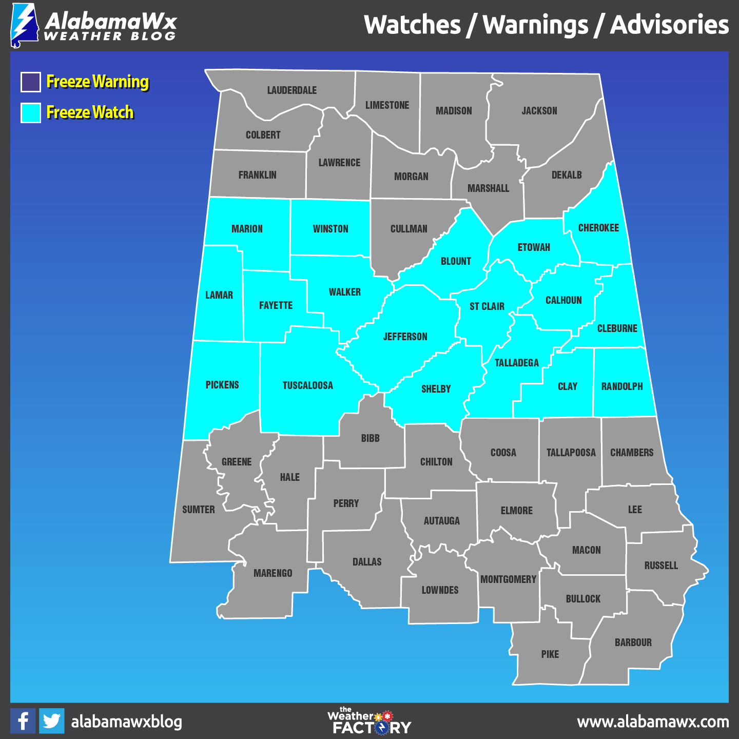
A Freeze Watch goes into effect this evening at 6:00 pm for Blount, Cherokee, Etowah, Fayette, Lamar, Marion, Walker, and Winston counties, while Calhoun, Clay, Cleburne, Jefferson, Pickens, Randolph, Shelby, St. Clair, Talladega, and Tuscaloosa goes under the watch starting at midnight tonight. The watch is set to expire at 8:00 am Sunday morning.
NICE BUT VERY COOL SATURDAY: We’ll have plenty of sunshine with cool dry continental air flowing into the state, keeping our highs down in the lower 40s to the lower 50s across Central Alabama from the northwest to the southeast. Winds will be out of the north at 5 to 15 MPH helping to make it feel even cooler. Skies will be clear for tonight and we can expect widespread frost across much of the area. Overnight lows will dip down into the upper 20s to the upper 30s, with a few of the colder spots possibly getting close to the teens.
RAIN RETURNS LATE SUNDAY: There will be a low forming just off of the southern Texas Gulf Coast that will be sending moisture up in our direction. Skies will start off clear, but clouds will begin to move in starting late in the morning and continue through the day. We could start to see an isolated shower or two throughout the afternoon and early evening hours, but higher rain chances will move in during the late night and overnight hours. Afternoon highs will be in the upper 40s to the upper 50s, and lows will be in the 40s.
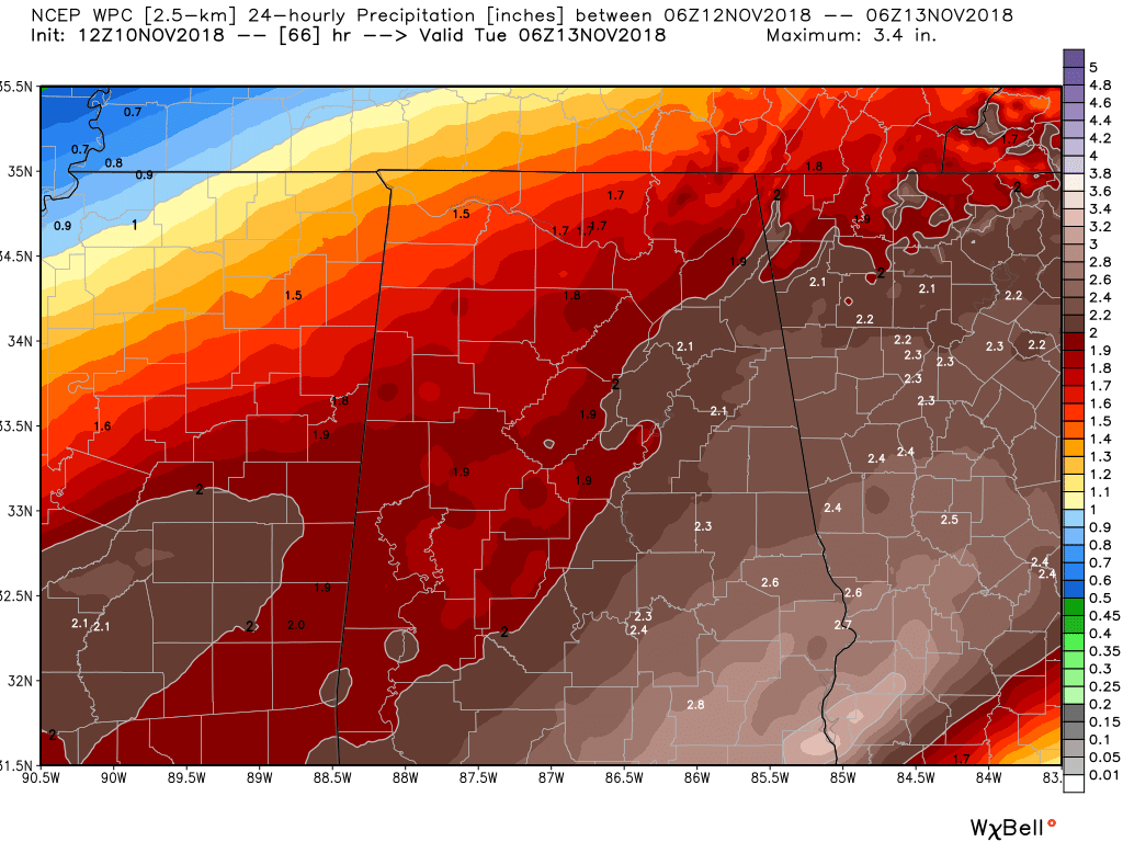
RAIN HEAVY AT TIMES ON MONDAY: A trough starts to dig in out to our west as it starts to move in our direction. The flow for us will be coming out of the southwest, helping to pull more moisture in over Central Alabama. We’ll have cloudy skies with rain likely throughout the day. Rain could be heavy at times, and we could see rainfall totals over 1.5 to 2.5 inches for much of Central Alabama by midnight. Highs will be in the upper 40s to the upper 50s.
EVEN COLDER AIR ARRIVES ON TUESDAY: A cold front will be moving through the state that will be bringing a reinforcing shot of colder air. Rain will be moving out early but skies may take a while before starting to clear out late in the day. Highs will be in the upper 30s to the upper 40s across the area from northwest to southeast. We’ll see the coldest temperatures of the season as lows on Wednesday morning are expected to be in the lower 20s to the lower 30s, with colder spots hitting the upper teens.
THE REST OF THE WORK WEEK: The good news is those afternoon highs will be on the increase on Wednesday through Friday, along with the chance to dry out for a few days. We’ll have plenty of sunshine each day with highs in the upper 40s to the lower 50s on Wednesday, warming into the mid to the upper 50s on Thursday, and reaching the upper 50s to the lower 60s on Friday.
NEXT WEEKEND: Just a quick peek into Voodoo Land for next weekend. Both Saturday and Sunday appear to be dry at this point with highs in the 50s.
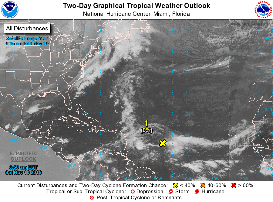
THE TROPICS: We have a tropical wave that has formed during the overnight hours a few hundred miles east of the Lesser Antilles. Conditions are not favorable for any development at this time, but by the middle of next week, those conditions will become a little more favorable for some tropical or subtropical development as it moves west-northwest. Just remember, the Atlantic Hurricane Season doesn’t end until the end of the month. The rest of the Atlantic Basin is quiet at this time.
Category: Alabama's Weather, ALL POSTS, WeatherBrains
About the Author (Author Profile)
Scott Martin is an operational meteorologist, professional graphic artist, musician, husband, and father. Not only is Scott a member of the National Weather Association, but he is also the Central Alabama Chapter of the NWA president. Scott is also the co-founder of Racecast Weather, which provides forecasts for many racing series across the USA. He also supplies forecasts for the BassMaster Elite Series events including the BassMaster Classic.Subscribe
If you enjoyed this article, subscribe to receive more just like it.


