Cloudy & Cold At Midday With A Few Showers
CONDITIONS ACROSS CENTRAL ALABAMA AT 11:00 AM CST
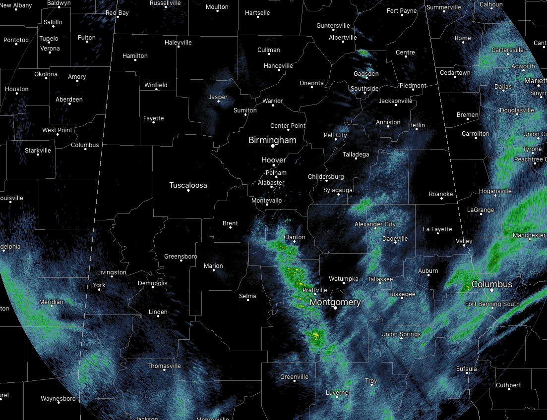
We have cloudy skies and cold temperatures across Central Alabama at this point on your Wednesday. To go along with that, we have some patchy to scattered showers out there mainly over the southern and southeastern parts of the area. No lightning on radar and none is expected throughout the rest of the day. All of the shower activity is moving off to the northeast.
Temperatures across the area are currently in the mid-30s to the upper 40s from northwest to southeast. The cool spot is Haleyville at 36 degrees, while the warm spots were Auburn and Troy at 48 degrees. Birmingham was at 45 degrees.
WEATHER FOR THE REST OF YOUR WEDNESDAY
We’ll continue to see spotty to scattered light to moderate rain showers across Central Alabama for the rest of the afternoon and through the early evening. While the chance of rain for any one spot look to be relatively high, there will be a decent amount of breaks in the rainfall. Skies will be cloudy and highs will only top out in the upper 30s to the mid-50s across the area from northwest to southeast. Rain chances will really start to drop off from west to east during the late night and through the overnight hours with the good news being that rain will have come to an end before temperatures drop below freezing. Overnight lows will be in the upper 20s to the lower 40s.
FREEZE WARNING STARTING AT MIDNIGHT
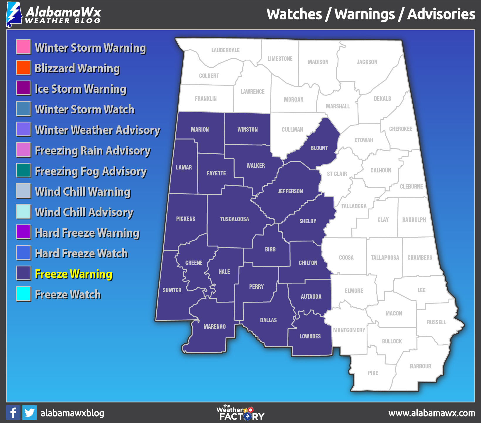
NWS Birmingham has issued a Freeze Warning for Thursday from 12:00 AM CST to 10:00 AM CST for Autauga, Bibb, Blount, Chilton, Dallas, Fayette, Greene, Hale, Jefferson, Lamar, Lowndes, Marengo, Marion, Perry, Pickens, Shelby, Sumter, Tuscaloosa, Walker, and Winston counties.
We also note that a Freeze Warning has been issued for the NWS Mobile counties in southwest Alabama (Baldwin, Butler, Choctaw, Clarke, Conecuh, Escambia, Mobile, Monroe, Washington, and Wilcox) for Thursday 12:00 AM CST to 9:00 AM CST.
Temperatures below freezing during these time will kill crops and sensitive plants. Please bring tend to your plants and bring your pets indoors until temperatures become more suitable.
A RAW COLD DAY ON THURSDAY
The low and associated cold front quickly lifts to the northeast and away from Central Alabama, bringing rain chances to an end by the mid-morning hours. Behind that, we’ll have cloud cover for a while until clearing starts in the southwest around the noon hour and gradually moves northeast. Winds will be averaging 5-10 MPH out of the west-northwest throughout the day, and afternoon highs will be in the upper 30s to the upper 40s. Wind chill values will be in the lower 20s to the lower 30s to start the day and only climb to the lower 30s to the lower 40s by the afternoon. The bad news is we drop back into the deep freeze once again as overnight lows will dip right back down into the mid-20s to the lower 30s. A Freeze Warning will probably be issued for late Thursday night into the early morning hours on Friday.
The good news is that high pressure will set up over the Texas Gulf Coast and move towards Louisiana, bringing a calmer weather pattern with warmer temperatures that will persist throughout the rest of the week and weekend.
Category: Alabama's Weather, ALL POSTS
About the Author (Author Profile)
Scott Martin is an operational meteorologist, professional graphic artist, musician, husband, and father. Not only is Scott a member of the National Weather Association, but he is also the Central Alabama Chapter of the NWA president. Scott is also the co-founder of Racecast Weather, which provides forecasts for many racing series across the USA. He also supplies forecasts for the BassMaster Elite Series events including the BassMaster Classic.Subscribe
If you enjoyed this article, subscribe to receive more just like it.


