Mostly Cloudy With Some Spotty Showers At Midday
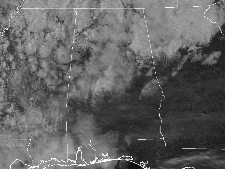
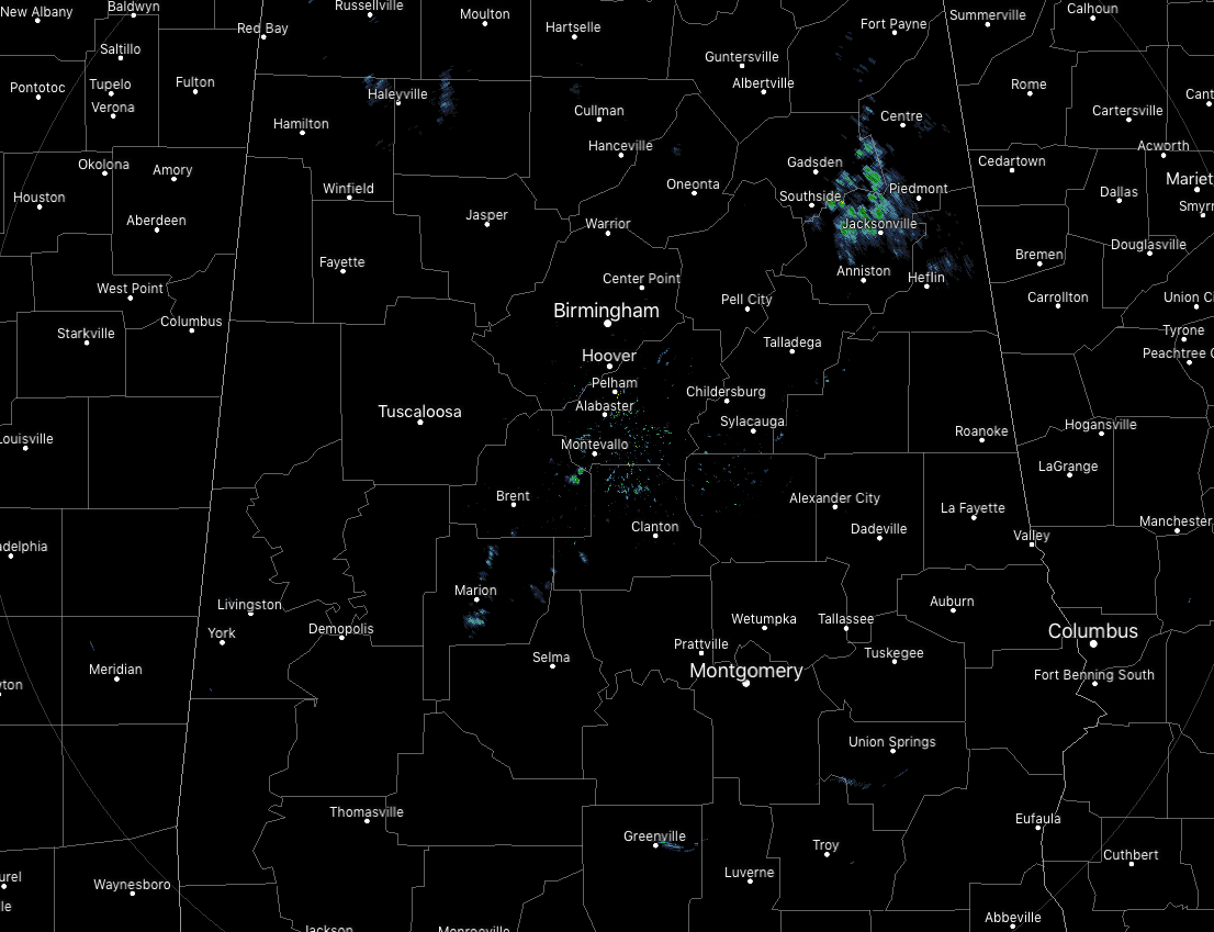
CONDITIONS ACROSS CENTRAL ALABAMA AT 12:00 PM: We have a good bit of cloud cover over much of Central Alabama at midday, but some sun is making it to the surface over the southern parts. Only some thin high clouds are filtering some of the sunshine over those parts. On radar, a few light and spotty showers are being seen over the northeastern parts of the area, mainly affecting Hokes Bluff, Jacksonville, Glencoe, and Alexandria. These showers are pushing off to the east and will be out of the area within the next 60-90 minutes. There are a few other spotty light showers or sprinkles over the western parts of the area, but will only last around 5-10 minutes over any location they pass over. Temperatures at noon are running from the lower 40s to the mid-60s across the area from northeast to southwest. The cold spot is Gadsden at 43 degrees while the warm spot is Demopolis at 66 degrees. Birmingham was at 61 degrees.
WEATHER FOR THE REST OF YOUR THURSDAY: Skies will be mainly cloudy across much of Central Alabama for the rest of the afternoon and into the early evening hours. A few spotty and light showers or sprinkles will be possible mainly along and to the north of the I-59 corridor, while the remainder of the area will remain dry. Afternoon highs will be in the mid-50s to the mid-60s across the area from northeast to southwest. Rain chances move farther south for the evening and overnight hours, while locations south of I-85 should remain rain-free. Rain chances range from 20% along and north of I-85 to as high as 60% in the northwestern corner of the area. Amounts will be light, around 0.10 inches, and overnight lows will be in the upper 40s to the upper 50s.
SHOWER CHANCES CONTINUE ON FRIDAY: About the same story with the rain chances on Friday as seen during the overnight hours… Rain chances will be highest in the northwestern parts of Central Alabama, while areas south of I-85 will remain dry. Skies will be mostly cloudy when not raining and afternoon highs top out in the lower 60s to the lower 70s across the area from northeast to southwest. 20% along and north of I-85 to as high as 60% in the northwestern corner of the area. Unfortunately, those rain chances look to slowly increase and move southeastwardly throughout the evening and into the overnight hours, making the possibility of the high school football playoff games wet. Showers are possible throughout the evening across the area, with temperatures in the upper 50s to the mid-60s around 6:00 pm and staying steady throughout the games. Rain increases during the overnight hours and lows mid-50s to the lower 60s.
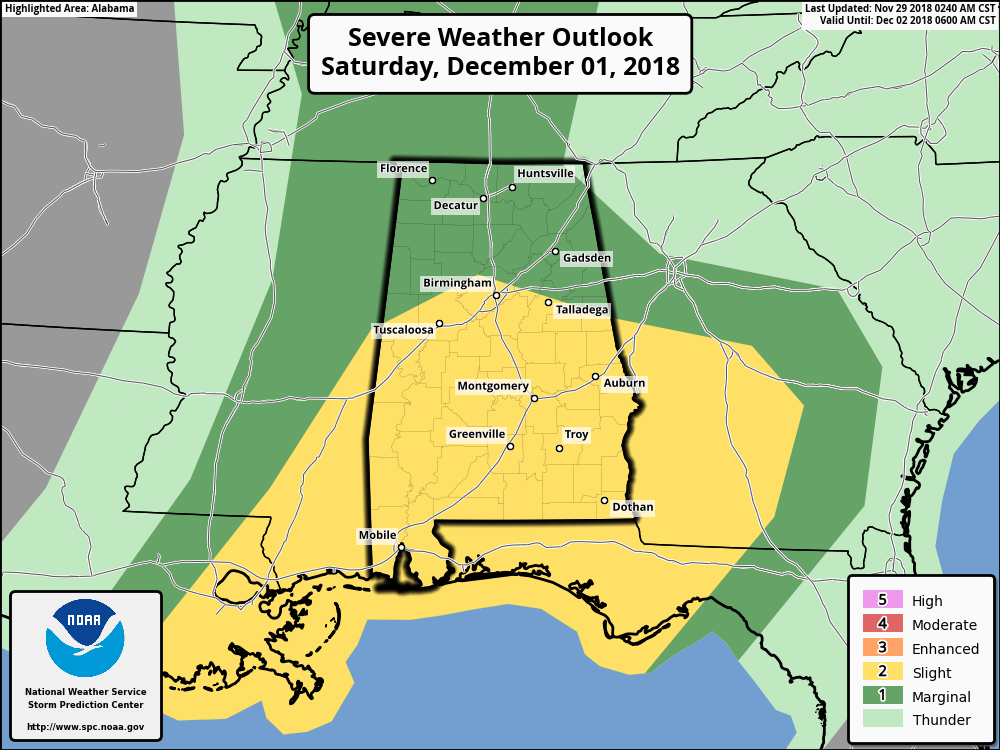
STRONG TO SEVERE STORMS CONTINUE TO BE POSSIBLE ON SATURDAY: The Storm Prediction Center continues to have much of Central Alabama in the standard Slight Risk for Severe Storms on Saturday, with the northern parts of the area in a Marginal Risk. By this evening, we should have a much better idea of what to expect as the higher resolution models will have the whole event within their window. As of now, it still appears that the system will be out of phase with the stronger storms occurring early and the dynamic support leaving the area before the main thermodynamics that supports the severe weather threat arrives later in the afternoon and into the evening hours. The limiting factor will be the possibility of convective storms developing along the gulf coast that could cut the flow of destabilizing air off from reaching the area. Still too early at this point as there is plenty of uncertainty, but we’ll keep you updated.
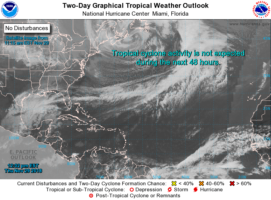
THE TROPICS: We only have 1-1/2 days remaining in the Atlantic Hurricane Season for 2018 as the end of the season occurs at the end of the day on Friday, November 30th. Looks like we are going to end the season on a quiet note as no development of tropical cyclones is expected through the next five days.
BEACH FORECAST CENTER: Get the latest weather and rip current forecasts for the beaches from Fort Morgan to Panama City on our Beach Forecast Center page. There, you can select the forecast of the region that you are interested in.
WE’RE HAVING A RECORD-BREAKING YEAR… ADVERTISE WITH US TODAY!: Don’t miss out! We have enjoyed over 18.5 MILLION page views on AlabamaWx.com so far in 2018. We can customize a creative, flexible and affordable package that will suit your organization’s needs. Contact Bill Murray at (205) 687-0782.
E-FORECAST: Get the Alabama Wx Weather Blog’s Seven-Day Forecast delivered directly to your inbox by email twice daily. It is the most detailed weather forecast available in Central Alabama. Subscribe here… It’s free!
CONNECT ON SOCIAL MEDIA: You can find the AlabamaWx Weather Blog on the major social media networks:
Facebook
Twitter
WEATHERBRAINS: Don’t forget you can listen to our weekly 90 minute netcast anytime on the web at WeatherBrains.com or on iTunes, Stitcher, or Spotify. This is the show all about weather featuring many familiar voices, including the meteorologists at ABC 33/40.
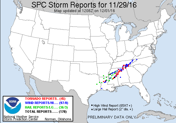
ON THIS DAY IN WEATHER HISTORY: 2016 – 11 tornadoes impacted parts of Central Alabama during a severe weather event that stretched from the evening hours on November 29th to the pre-dawn hours on November 30th. The good news is that there were no injuries or deaths recorded. There were two EF-2 tornadoes, seven EF-1 tornadoes, and two EF-0 tornadoes.
Category: ALL POSTS, Archived Warnings
About the Author (Author Profile)
Scott Martin is an operational meteorologist, professional graphic artist, musician, husband, and father. Not only is Scott a member of the National Weather Association, but he is also the Central Alabama Chapter of the NWA president. Scott is also the co-founder of Racecast Weather, which provides forecasts for many racing series across the USA. He also supplies forecasts for the BassMaster Elite Series events including the BassMaster Classic.Subscribe
If you enjoyed this article, subscribe to receive more just like it.


