Cloudy, Cold, & Light Showers Falling Across Central Alabama
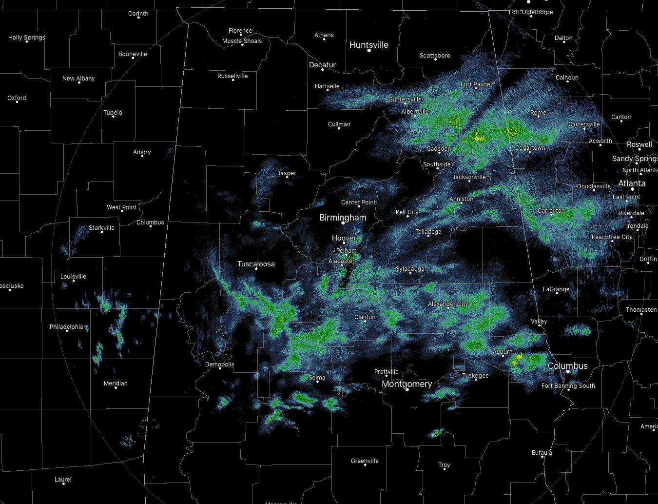
RADAR CHECK AT 1:25 PM: Light showers continue to fall across a good portion of Central Alabama as we have crossed over into the early afternoon hours on this last workday for the first full work week of December. If it not raining in your location at this point, clouds are what you’ll see if you look to the sky. Temperatures are still rather cool in the northern 2/3rds of the area in the lower 40s to the lower 50s, while we are seeing mid-50s to the lower 60s across the southern 1/3rd. The warm spot is Eufaula at 60 degrees while the cool spots were Haleyville and Alabaster at 43 degrees. Birmingham was just a touch warmer at 45 degrees.
WEATHER FOR THE REST OF YOUR FRIDAY: While we do have a drop off in shower activity across much of the area at this point, more showers are expected to move in across the area later this afternoon and into the early evening hours. Rain chances will be the highest north of the US-80 and I-85 corridors (70-80%) while chances drop as you move south of that (40%-60%). Afternoon highs will top out across the area in the lower 40s in the north to the lower 60s in the south. For tonight, more rain will continue to stream into Central Alabama from the west, and rain will be widespread north of the US-80 and I-85 corridors. Rain chances south of that will be lower as you move south (20-60%). Overnight lows will only drop into the lower to mid-40s across the area.
COLD AND WET THROUGHOUT THE DAY ON SATURDAY: Saturday will not be a nice day at all if you have any outdoor activities. Skies will be cloudy and rain will fall throughout much, if not all, of the day. Don’t expect it to be any warmer as afternoon highs will only reach the lower 40s to near 50 degrees across the area from north to south. Rain continues during the evening and overnight hours with lows in the upper 30s to the mid-40s.
BEACH FORECAST CENTER: Get the latest weather and rip current forecasts for the beaches from Fort Morgan to Panama City on our Beach Forecast Center page. There, you can select the forecast of the region that you are interested in.
WE’RE HAVING A RECORD-BREAKING YEAR… ADVERTISE WITH US TODAY!: Don’t miss out! We have enjoyed over 18.7 MILLION page views on AlabamaWx.com so far in 2018. We can customize a creative, flexible and affordable package that will suit your organization’s needs. Contact Bill Murray at (205) 687-0782.
E-FORECAST: Get the Alabama Wx Weather Blog’s Seven-Day Forecast delivered directly to your inbox by email twice daily. It is the most detailed weather forecast available in Central Alabama. Subscribe here… It’s free!
CONNECT ON SOCIAL MEDIA: You can find the AlabamaWx Weather Blog on the major social media networks: Facebook & Twitter.
WEATHERBRAINS: Don’t forget you can listen to our weekly 90 minute netcast anytime on the web at WeatherBrains.com or on iTunes, Stitcher, or Spotify. This is the show all about weather featuring many familiar voices, including the meteorologists at ABC 33/40.
ON THIS DAY IN WEATHER HISTORY: 1740 – In early December two weeks of mild and rainy weather culminated in the worst flood in fifty years in the Lower Connecticut River Valley. The Merrimack River swelled to its highest level, and in Maine the raging waters swept away mills, carried off bridges, and ruined highways.
Category: Alabama's Weather, ALL POSTS
About the Author (Author Profile)
Scott Martin is an operational meteorologist, professional graphic artist, musician, husband, and father. Not only is Scott a member of the National Weather Association, but he is also the Central Alabama Chapter of the NWA president. Scott is also the co-founder of Racecast Weather, which provides forecasts for many racing series across the USA. He also supplies forecasts for the BassMaster Elite Series events including the BassMaster Classic.Subscribe
If you enjoyed this article, subscribe to receive more just like it.


