New Mesoscale Precipitation Discussion Includes Parts Of Central Alabama
The latest Mesoscale Precipitation Discussion from the NWS Weather Prediction Office was just released and there is talk about the excessive rainfall affecting parts of Central Alabama. Showers and a few storms are becoming more organized back to our southwest. There is a potential of some flash flooding in low-lying and poor drainage areas as rainfall rates at some point could be as high as 1.00-inch per hour over parts of the area. Here is the discussion:
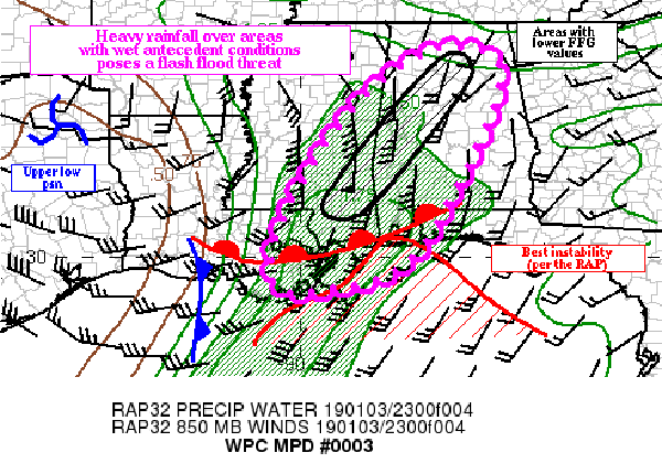
Mesoscale Precipitation Discussion 0003
NWS Weather Prediction Center College Park MD
8:09 PM EST – Thu Jan 03 2019
Areas affected: Eastern LA, Southern MS, and into Western and Central AL.
Concerning: Heavy rainfall with flash flooding possible.
Summary:
Heavy rainfall over areas with wet antecedent conditions could pose a flash flood threat into the late evening and overnight hours.
Discussion:
Regional radars across the Lower MS Valley and the central Gulf Coast showed low topped convection becoming better organized across far eastern LA into southern MS. Instability is fairly meager (with the 04/00z KLIX sounding showing 295 J/KG of SBCAPE), yet the low topped convection appears to be forming in a long ahead of a cold front over South-Central LA.
Ahead of the front, a 35-40 knot low-level inflow is transporting 1.75-inch precipitable water air across Southern MS into West-Central AL. The low topped storms (which have yet to produce lightning, even over the northern Gulf of Mexico) have been producing hourly rainfall rates near 0.50 inches (per the KLIX radar) as it crossed easternmost LA). However, MESONET observations near the line have indicated hourly rainfall near an inch.
The depth of the moisture in the column (the 04/00z KLIX sounding had a precipitable water value of 1.85 inches), combined with marginal instability (as shown by the latest rap across portions of southernmost MS and Southwest AL) could result in hourly rainfall rates near 1.00 inches through 04/05z. The line itself is fairly progressive, but the heavy rainfall is moving into areas with wet antecedent conditions. Portions of Southeast MS into West-Central AL have received 400 percent of their normal rainfall over the past 14 days, and this is reflected in the 1-hour flash flood guidance values (which are as low as an inch in these areas).
Despite the lack of deeper instability, and the progressive nature of the line of low topped convection, hourly rainfall rates near an inch could pose a flash flood threat where guidance values are near an inch. Because of this, flash flooding is considered possible through the late evening hours.
Category: Alabama's Weather, ALL POSTS
About the Author (Author Profile)
Scott Martin is an operational meteorologist, professional graphic artist, musician, husband, and father. Not only is Scott a member of the National Weather Association, but he is also the Central Alabama Chapter of the NWA president. Scott is also the co-founder of Racecast Weather, which provides forecasts for many racing series across the USA. He also supplies forecasts for the BassMaster Elite Series events including the BassMaster Classic.Subscribe
If you enjoyed this article, subscribe to receive more just like it.


