Beautiful, Breezy, & A Little Cool At Midday
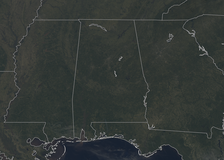
As we make our way to the midday hour on your Wednesday, skies across Central Alabama appear to be crystal clear on the latest visible satellite image. As a matter of fact, the closest clouds to the area are located down over the Gulf of Mexico a little way offshore of the Gulf Coasts of Alabama and the Florida Panhandle. It is breezy at times with winds currently averaging 10-15 MPH out of the northwest. Those winds will make the current temperatures in the mid-40s to the mid-50s across the area feel a few degrees cooler. The warm spot is Eufaula at 57 degrees, the only station in the upper 50s, while the cool spot is Haleyville at 46 degrees, the only station still in the 40s.
WEATHER FOR THE REST OF YOUR WEDNESDAY
The rest of the afternoon and into the early evening hours will remain brilliant and just on the cool side. We’ll have nearly maximum sunshine and a little breeze out of the northwest around 10-15 MPH. Afternoon highs should make it up into the lower 50s to right at 60 degrees across the area from northwest to southeast. It will be a chilly night across the area tonight and through the overnight hours with mainly clear skies. Lows will dip down into the mid-20s to the lower 30s.
EVEN COOLER ON THURSDAY
While we’ll once again have plenty of sunshine with one or two passing clouds, temperatures will be around 7-10 degrees cooler than today. Afternoon highs will only be in the mid-40s to right around 50 degrees across the area from northwest to southeast.
BEACH FORECAST CENTER
Get the latest weather and rip current forecasts for the beaches from Fort Morgan to Panama City on our Beach Forecast Center page. There, you can select the forecast of the region that you are interested in.
WE HAD A RECORD-BREAKING YEAR IN 2018! ADVERTISE WITH US TODAY ON THE ALABAMAWX WEATHER BLOG!
We have enjoyed over 19.9 MILLION page views on AlabamaWx.com for 2018… breaking our previous record by over 3 million page views. Don’t miss out! We can customize a creative, flexible and affordable package that will suit your organization’s needs. Contact Bill Murray at (205) 687-0782.
E-FORECAST
Get the Alabama Wx Weather Blog’s Seven-Day Forecast delivered directly to your inbox by email twice daily. It is the most detailed weather forecast available in Central Alabama. Subscribe here… It’s free!
CONNECT WITH THE ALABAMAWX WEATHER BLOG ON SOCIAL MEDIA
You can find the AlabamaWx Weather Blog on the major social media networks:
Facebook
Twitter
WEATHERBRAINS
Don’t forget you can listen to our weekly 90 minute netcast anytime on the web at WeatherBrains.com or on iTunes, Stitcher, or Spotify. This is the show all about weather featuring many familiar voices, including the meteorologists at ABC 33/40.
ON THIS DAY IN WEATHER HISTORY
1990 – The third storm in four days hit the Pacific Northwest. Winds in Oregon gusted above 100 mph at Netarts and at Oceanside. Up to 8.16 inches of rain was reported around Seaside OR, and the total of 4.53 inches of rain at Astoria OR was a record for the date. Twelve cities in the western U.S. reported record high temperatures for the date. The high of 70 degrees at Cedar City UT was a record for January.
Category: Alabama's Weather, ALL POSTS
About the Author (Author Profile)
Scott Martin is an operational meteorologist, professional graphic artist, musician, husband, and father. Not only is Scott a member of the National Weather Association, but he is also the Central Alabama Chapter of the NWA president. Scott is also the co-founder of Racecast Weather, which provides forecasts for many racing series across the USA. He also supplies forecasts for the BassMaster Elite Series events including the BassMaster Classic.Subscribe
If you enjoyed this article, subscribe to receive more just like it.


