

A Globe Of Bright Light Finally Brightens Our Midday
TODAY: After a few days of dull, dreary, and cloudy skies, we have finally returned to having maximum sunshine across Central Alabama as of the midday hour on your “Hump Day.” Temperatures at 12:30 PM are running in the min-40s to the mid-50s across the area, and those should warm a little more into the lower to upper 50s by later this afternoon. Unfortunately, the bright sunshine will only last for a day this time as more clouds associated with our next rain-maker will start to move in overnight. We’ll stay dry through the overnight hours and lows will be in the mid-30s to the lower 40s across the area.
THURSDAY: A center of low pressure will start off the day over the northwestern corner of Arkansas and will move while weakening into Central Kentucky by the evening. This will bring cloud cover and the chance of showers to the area throughout the day on Thursday. Rain chances will be highest in the extreme northern and northwestern counties and drop as you move south and southeastward. Some locations in the southeastern parts of the area south of I-85 may not even see a drop of rain. Afternoon highs will be in the lower 50s to the lower 60s with rain chances ranging from 20% to 50% from southeast to northwest. There may be an isolated shower or two over the northern parts of the area during the late night and overnight hours while the southern half should be dry. Lows will be in the mid-40s to the lower 50s.
NORMALS FOR TODAY: Our normal high in Birmingham for January 16th is 52 degrees while our normal low is 32 degrees. Today’s forecast high is 54 degrees, so we are just above normal for the high. Tonight’s forecast low of 39 degrees is several degrees warmer than our normal low, but that will be due to the increased cloud cover trapping some of the radiational heating in from the day.
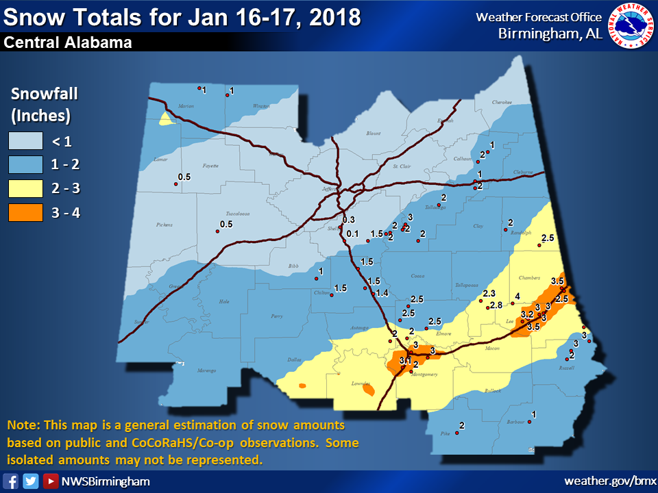
THIS DAY IN WEATHER HISTORY: (From NWS Birmingham) The January 16th, 2018, snow-maker was another installment of an active winter season across Central Alabama, including surges of arctic air and frozen precipitation. This event was a rather uncommon snow setup for Central Alabama, with temperature profiles favorable for snow arriving just ahead of the precipitation vs. cold air chasing the last bit of departing precipitation. The main uncertainty with this system was with the extent of accumulating snowfall; however, it was evident that even light snow accumulations would result in travel impacts given temperatures falling into the 20s and then 10s across Central Alabama. Due to arctic origins, snow to liquid ratios was on the higher side for this region of the country, at least 15:1 with this event.
During the morning of January 16th, a band of light snowfall moved into Northwest Alabama and then progressed toward the I-20 corridor during the afternoon as it trended toward a weakened state. Due to limited moisture content, a trace to less than 1” of snow resulted from the band on average. At the same time, an upstream 500mb trough continued its trend of digging southward, with a lobe of energy and an associated swath of higher moisture content that would ultimately be aimed at areas along and either side of the I-85 corridor. For these areas, between 2” to 4” of snow fell during the evening of January 16th and into the early-morning hours of the 17th.
Interestingly, the upper trough was still driving periods of banded snowfall as far northwest as the I-20 corridor into the evening. Here, the leading edge of drier low-level air was advecting into the area, but sufficient moisture aloft remained. Higher tilts of RADAR scans showed relatively enhanced echoes, but nothing was reaching the surface until snow broke through the dry layer. This happened very suddenly near the I-20 corridor, resulting in a quick burst of accumulating snowfall with snow rates near 1”/hour. These bands then advanced southeast toward the I-85 corridor, combining with the ongoing shield of snow.
Some portions of Central Alabama ended up bottoming out in the single digits on the morning of the 17th, and northerly breezes behind the front pushed wind chill values into the single digits and even just below zero across the board. The most significant travel impacts were along and either side of the I-85 corridor and along a stretch of I-65 in Chilton and Autauga Counties, where ice-covered roadways resulted in road closures and stuck vehicles and big rigs. Elsewhere, icy roadways were reported as well, though lighter snow totals and blowing of snow from road surfaces helped limit the overall scope of impacts.
BEACH FORECAST CENTER: Get the latest weather and rip current forecasts for the beaches from Fort Morgan to Panama City on our Beach Forecast Center page. There, you can select the forecast of the region that you are interested in.
WE HAD A RECORD-BREAKING YEAR IN 2018! ADVERTISE WITH THE BLOG!: We have enjoyed over 19.9 MILLION page views on AlabamaWx.com for 2018… breaking our previous record by over 3 million page views. Don’t miss out! We can customize a creative, flexible and affordable package that will suit your organization’s needs. Contact Bill Murray at (205) 687-0782.
E-FORECAST: Get the Alabama Wx Weather Blog’s Seven-Day Forecast delivered directly to your inbox by email twice daily. It is the most detailed weather forecast available in Central Alabama. Subscribe here… It’s free!
CONNECT WITH THE BLOG ON SOCIAL MEDIA: You can find the AlabamaWx Weather Blog on the major social media networks:
Facebook
Twitter
WEATHERBRAINS: Don’t forget you can listen to our weekly 90 minute netcast anytime on the web at WeatherBrains.com or on iTunes, Stitcher, or Spotify. This is the show all about weather featuring many familiar voices, including the meteorologists at ABC 33/40.
Category: Alabama's Weather, ALL POSTS
About the Author (Author Profile)
Scott Martin is an operational meteorologist, professional graphic artist, musician, husband, and father. Not only is Scott a member of the National Weather Association, but he is also the Central Alabama Chapter of the NWA president. Scott is also the co-founder of Racecast Weather, which provides forecasts for many racing series across the USA. He also supplies forecasts for the BassMaster Elite Series events including the BassMaster Classic.Subscribe
If you enjoyed this article, subscribe to receive more just like it.


