The Older Tornado Warning For Northeastern Greene County Is Cancelled But New Warning Continues for Other Parts of Greene and Tuscaloosa Counties

…THE TORNADO WARNING FOR NORTHEASTERN GREENE COUNTY IS CANCELLED…
The tornadic thunderstorm which prompted the warning has moved out of the warned area. Therefore, the warning has been cancelled. A Tornado Watch remains in effect until 500 PM CST for west central Alabama. LAT…LON 3308 8783 3302 8783 3302 8771 3299 8771 3298 8775 3297 8774 3296 8779 3291 8796 3298 8798 TIME…MOT…LOC 1617Z 233DEG 45KT 3303 8779
A Tornado Warning Remains In Effect Until 10:30 AM CST For Northeastern Greene County
Jan 19th @ 10:08 am

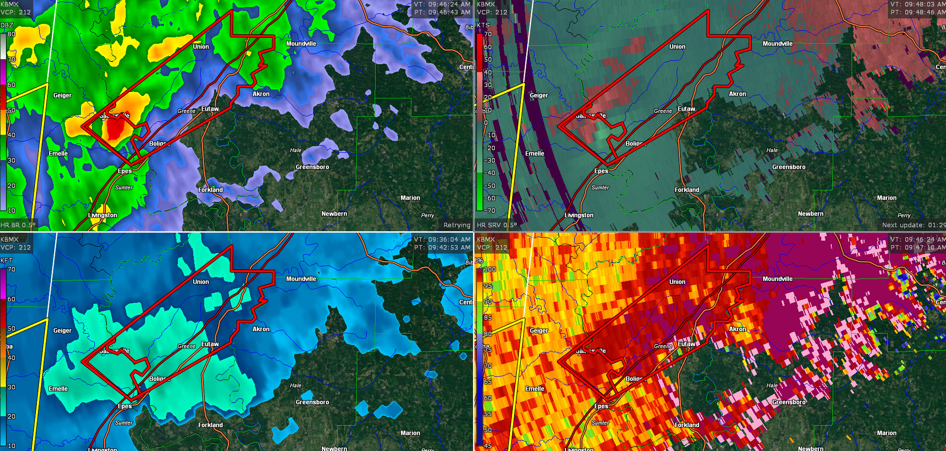
…A TORNADO WARNING REMAINS IN EFFECT UNTIL 1030 AM CST FOR NORTHEASTERN GREENE COUNTY… At 1007 AM CST, a severe thunderstorm capable of producing a tornado was located over Union, or 7 miles north of Eutaw, moving northeast at 50 mph.
HAZARD…Tornado.
SOURCE…Radar indicated rotation.
IMPACT…Flying debris will be dangerous to those caught without shelter. Mobile homes will be damaged or destroyed. Damage to roofs, windows, and vehicles will occur. Tree damage is likely. Locations impacted include… Union, Knoxville and Snoddy.
A Tornado Warning Remains In Effect Until 10:30 AM CST For Northeastern Greene County
Jan 19th @ 10:01 am

…A TORNADO WARNING REMAINS IN EFFECT UNTIL 1030 AM CST FOR NORTHEASTERN GREENE COUNTY… At 1000 AM CST, a severe thunderstorm capable of producing a tornado was located near West Greene, or 7 miles northwest of Eutaw, moving northeast at 45 mph.
HAZARD…Tornado.
SOURCE…Radar indicated rotation.
IMPACT…Flying debris will be dangerous to those caught without shelter. Mobile homes will be damaged or destroyed. Damage to roofs, windows, and vehicles will occur. Tree damage is likely. Locations impacted include… Union, Knoxville, Snoddy and Clinton.
The Tornado Warning For North Central Sumter County Is Cancelled
Jan 19th @ 10:00 am

…THE TORNADO WARNING FOR NORTH CENTRAL SUMTER COUNTY IS CANCELLED…
The tornadic thunderstorm which prompted the warning has moved out of the warned area. Therefore, the warning has been cancelled. A Tornado Watch remains in effect until 500 PM CST for west central Alabama.
Tornado Warning Issued For Parts Of Greene And Sumter Counties Until 10:30AM
Jan 19th @ 9:43 am
UPDATE 9:50 AM
Radar continues to indicate rotation on a storm that will be moving from Sumter into Greene County in West Alabama.
Conditions are favorable for a tornado to form at any time if it hasn’t already. There is plenty of wind shear, especially low-level helicity.
The highest danger is currently south of Gainesville and will move to the north of Boligee and generally between Union and Eutaw in Greene County.
All residents in the tornado warning polygon need to be going into their tornado safe places now, which is a center room on the lowest floor in a substantial home or building.

The National Weather Service in Birmingham has issued a
* Tornado Warning for…
Central Greene County in west central Alabama…
North central Sumter County in west central Alabama…
* Until 1030 AM CST.
* At 943 AM CST, a severe thunderstorm capable of producing a tornado was located near Gainesville, or 11 miles north of Livingston, moving northeast at 50 mph.
HAZARD…Tornado.
SOURCE…Radar indicated rotation.
IMPACT…Flying debris will be dangerous to those caught without shelter. Mobile homes will be damaged or destroyed.
Damage to roofs, windows, and vehicles will occur. Tree damage is likely.
* Locations impacted include…
Eutaw, Boligee, Union, Gainesville, Knoxville, Allison, Snoddy, New
Mount Hebron, I 20 Rest Area Near Eutaw and Clinton.
Category: ALL POSTS
About the Author (Author Profile)
Subscribe
If you enjoyed this article, subscribe to receive more just like it.


