Update On The Snow Potential Tuesday Morning
An Arctic cold front will pass through Alabama early Tuesday morning, and along with it comes a chance of snow, which will bring potential for travel impact and schedule disruptions. Here is a Saturday morning update.
TIMING: Precipitation will initially begin as light rain late Monday night and during the pre-dawn hours Tuesday. There will be a quick change to snow as cold air rushes into the state. The main window for snow in Alabama will come from 2:00 a.m. until 12:00 noon.
AMOUNTS: With a northwest flow system like this, precipitation amounts are generally light; this is not a Gulf of Mexico winter storm. Snow accumulation over the northern half of Alabama will be generally in the 1/2 to 1 inch range; there is potential for isolated amounts to 2 inches near the Tennessee state line.
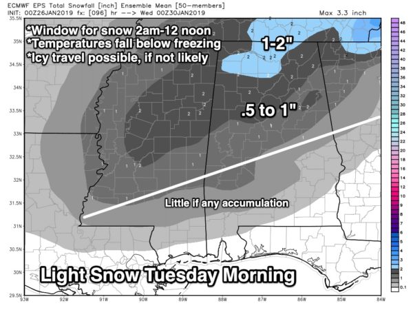
BOOM: There is always uncertainty involving any winter weather event in Alabama. We prefer to give a range of snow possibilities; the “boom” potential, on the high end, is 4 inches across parts of North Alabama. Unlikely, but not impossible.
BUST: On the low end, there is a chance we have nothing more than flurries and no accumulation or impact.
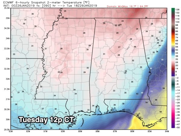
TRAVEL: With temperatures expected to fall into the sub-freezing zone during the day, icy travel is expected. Initially on bridges, and then potentially on all road surfaces. The key is the depth of the cold air. If we drop into the mid 20s by mid to late afternoon as some models suggest, there is potential for a “flash freeze” with melted snow and some very serious travel issues. But, if we only drop into the low 30s, most black top roads will be just wet with ice mainly on bridges. But for now understand road conditions will most likely deteriorate during the day Tuesday, and icy travel will remain possible Tuesday night into Wednesday morning. Temperatures should drop into the 18-22 degree range both mornings.
We will have a much better grasp on the degree of the temperature drop as we get closer to the event.
COLD: The latter half of next week will be very cold, with potential for lows in the teens on many mornings across North Alabama. Our friends up north, near the Canadian border in North Dakota and Minnesota could see wind chill index values to -50F by mid-week. Thankfully we just catch the edge of that brutally cold airmass.
Keep an eye on the blog for forecast updates over the weekend.
Category: Alabama's Weather, ALL POSTS, Winter Weather
About the Author (Author Profile)
James Spann is one of the most recognized and trusted television meteorologists in the industry. He holds the AMS CCM designation and television seals from the AMS and NWA. He is a past winner of the Broadcast Meteorologist of the Year from both professional organizations.Subscribe
If you enjoyed this article, subscribe to receive more just like it.


