Sunday Morning Look At The Tuesday Snow Potential
Snow is likely across much of North/Central Alabama Tuesday morning with potential for travel impact. Here is the latest thinking…
TIMING: Rain ahead of an Arctic front will change quickly to snow Tuesday morning. We now believe the main window for snow will come from 2:00 until 10:00 a.m. The snow won’t last long at any given point (2-3 hours), but snow rates could be locally heavy.
AMOUNTS/PLACEMENT: Northeast Alabama will have potential for 2-3 inches of snow; 1-2 inch snow potential is forecast down to the I-20 corridor. Some accumulation is very possible south of I-20, but amounts should be light. A few snow flakes could be seen as far south as Montgomery, but significant accumulation there looks unlikely at this point.
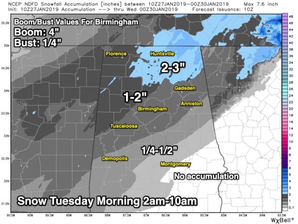
BOOM/BUST: For the Birmingham metro, the “boom” value is 4 inches. Possible, but not likely. The “bust” value on the low end is 1/4″. These are the range limits, and are a way of communicating uncertainty.
IMPACT: The travel impact will be determined by the degree of the temperature fall behind the Arctic front, and the snow rates. If temperatures fall into the mid 20s and stay there, then icy travel is possible on any road surface. If temperatures settle into the low 30s, then icy spots are likely on bridges, but black top road surfaces will be generally wet with isolated icy spots.
Also, if the snow becomes heavy at times, that would mean a greater threat of hazardous travel on all road surfaces. Bottom line is that we have to plan on deteriorating road conditions Tuesday morning.
DURATION: With temperatures dropping into the 18-22 degree range late Tuesday night and Wednesday morning, this means icy travel conditions will likely continue through mid-day Wednesday, when temperatures rise above freezing. The high Wednesday afternoon should be in the 38-44 degree range across North/Central Alabama.
REMEMBER: We are still 40-48 hours away from this event, and the forecast could change. Keep an eye on the blog for updates!
Category: Alabama's Weather, ALL POSTS, Winter Weather
About the Author (Author Profile)
James Spann is one of the most recognized and trusted television meteorologists in the industry. He holds the AMS CCM designation and television seals from the AMS and NWA. He is a past winner of the Broadcast Meteorologist of the Year from both professional organizations.Subscribe
If you enjoyed this article, subscribe to receive more just like it.


