Snow Event Coming Early Tuesday Morning; Very Cold Conditions Follow
We continue to closely monitor the potential for a snow event on Tuesday that will cause travel impacts across much of North and Central Alabama. Let’s dig into the details.
SEASONABLY COOL SUNDAY: Not a bad day today. Most places are starting off near freezing, but with a decent supply of sunshine, highs this afternoon will average out in the middle 50s. Most everyone should stay above freezing tonight.
BREEZY MONDAY: Tomorrow should be slightly warmer, with a breezy southwest wind. Highs will be in the upper 50s.
ARCTIC FRONT: An approaching arctic front will spread precipitation into Northwest Alabama late tomorrow afternoon and evening. It should begin as rain, but quickly change to snow as cold air pours into the state. Light now should become fairly widespread during the pre-dawn hours, spreading southeastward. The snow will end by mid=morning over northwestern sections and by early afternoon over southeastern parts of Central Alabama.
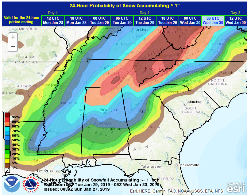
Weather Prediction Center Probability of Snow Accumulating Greater than or Equal to 1 Inch now 50% or higher over the northern half of Alabama
SNOWFALL AMOUNTS: The devil is in the details as they say, but 1-3 inches of snow is the forecast for areas generally along and north of a line from Demopolis to Calera to Ashland. Areas south to Butler, Montgomery, and Lanett will see a dusting to 1/2 inch of snow. Be on alert that some spots will probably pick up as much as 4 inches of snow, but that will involve some last minute developments and will be hard to pinpoint until the event unfolds on Tuesday.
TRAVEL IMPACTS: With temperatures falling into the 20s, road problems will begin quickly Tuesday morning, starting on bridges and then to most road surfaces. The bottom line, is plan for hazardous driving conditions Tuesday.
COLD WILL FOLLOW: Chicago is expecting lows of -19F by Wednesday morning. We won’t be that cold here, mainly lower 20s (although a snow cover could push some spots into the teens Wednesday morning). Teens to near 20F readings will be common Thursday morning. Tuesday highs will come before sunrise, with readings in the 20s during the day. Wednesday highs will struggled to get out of the 30s and Thursday highs will struggle to reach 50F.
MORE SNOW TO OUR NORTH WEDNESDAY: Another band of snow will affect Tennessee on Wednesday, perhaps dropping another inch of snow for places like Nashville, but it should stay north of us.
LATE WEEK WARMUP: We will recover to near 50F on Friday with 50s for Saturday and Sunday. Lows will be near or below freezing.
NEXT WEATHERMAKER: Rain returns to Alabama on Sunday and lasts into Monday or Tuesday. This system could bring another inch or so of rain.
VOODOO TERRITORY: Look for another protracted rain event around Monday the 11th, with heavy rain possible for North Alabama.
WEATHERBRAINS: Looking forward to speaking with our old friend Dr. Jon Nese from Penn State on Monday night’s WeatherBrains. Check out the first and longest running weather podcast at WeatherBrains.com.
We will have frequent updates on the blog from now through midweek as this winter storm event unfolds across Alabama.
Category: Alabama's Weather, ALL POSTS
About the Author (Author Profile)
Bill Murray is the President of The Weather Factory. He is the site's official weather historian and a weekend forecaster. He also anchors the site's severe weather coverage. Bill Murray is the proud holder of National Weather Association Digital Seal #0001 @wxhistorianSubscribe
If you enjoyed this article, subscribe to receive more just like it.


