Significant Threat for Severe Weather This Afternoon and Tonight for Parts of Alabama, Including Tornadoes
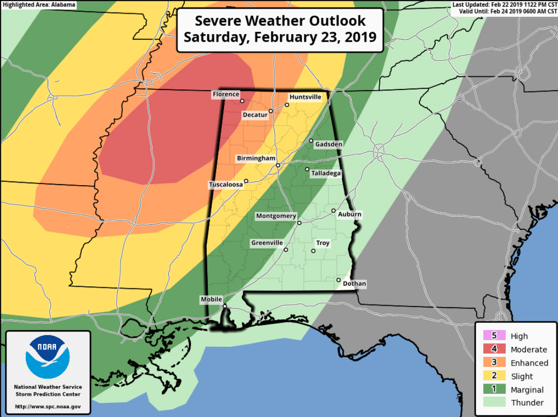
SPC Severe Weather Outlook for Today and Tonight
A significant early season severe weather outbreak is expected this afternoon and tonight across the South, including Alabama.
THREATS: Strong tornadoes, damaging winds, and large hail.
TIMING: 5 p.m. in Northwest sections around Franklin and Marion Counties, into West Alabama for Lamar and Pickens between 6-7 p.m. Jasper by 7-8 p.m., Tuscaloosa and Cullman before 8-9 p.m. and the Birmingham area by 9-10 p.m.
GREATEST RISK AREA: Areas northwest of a line from Emelle in Sumter County to Jasper to Huntsville, including parts of Sumter, Lamar, Fayette, Walker Marion, Winston, Franklin, Colbert, Lauderdale, Limestone, Lawrence, Madison, Morgan, and Cullman Counties. Cities in the greatest risk include Carrollton, Vernon, Fayette, Jasper. Hamilton, Double Spring, Russellville, Florence, Moulton, Decatur, Huntsville, and Athens.
SETUP: The strong upper-level system that has brought record-setting snows to the west will depart the Rockies this morning and finally move eastward. Strong southwesterly flow aloft ahead of the trough continues from Texas into the Ohio Valley. A strong low-level jet at 5000 feet exists this morning from Texas to Tennessee, pumping lows of moisture northward. The special balloon sounding at midnight showed precipitable water values of 1.55 inches at Birmingham. This is a record for this date. A surface low is over the Texas Panhandle. Low-level winds are out of the south and southeast. To the east, a cold air damming feature is over Georgia with a warm front over South Central Alabama.
SEVERE WEATHER PARAMETERS: By noon, surface temperatures will be in the middle 70s over Central Mississippi and West Alabama. Dewpoints will be in the upper 60s to near 70. Eastern Alabama will still be cooler with the wedge in place, but that will quickly be eroded as the warm front progresses northward. By 4-5 p.m., CAPE values across areas west of I-65 in Alabama will be in the 1,000-1,500 joules/kg range, with some higher values possible. Deep layer shear of 50-5 knots will allow for strong storm organization. Low-level shear values over West Alabama will rapidly increase to between 325-450 m2/s2 by 6-7 p.m. Instability will wane after sunset, but before it does, there could be a few strong tornadoes over West Alabama.
HOW THE SITUATION WILL UNFOLD: By noon, a line of strong storms should be crossing the Mississippi River. They will intensify during the afternoon across Mississippi as significant tornado parameter values increase to the 2 to 8 range. Long for strong tornadoes to occur across northern Mississippi from Greenville to Tupelo and Oxford over to Starkville and into southern Tennessee around Lawrenceburg. These storms will move into west Alabama by 5 p.m.in northwest sections around Franklin and Marion Counties, into West Alabama for Lamar and Pickens between 6-7 p.m. Jasper by 7-8 p.m., Tuscaloosa and Cullman before 8-9 p.m. and the Birmingham area by 9-10 p.m. The storms will congeal into a squall line that will push eastward during the evening hours with a strong damaging wind threat.
FLASH FLOOD THREAT: Heavy rain is falling this morning across parts of Walker, Winston< Cullman, Morgan and Marshall Counties. Storm total rainfalls are already in the 3-7 inch ranch across much of North Central Alabama in areas north of Birmingham. The worst is across parts of Winston, Walker, Franklin, Cullman, Etowah, Calhoun and Cherokee Counties, where widespread 5-7 inch amounts have fallen. Areal flood and flash flood watches remains in effect for areas generally along and north of I-20 until Sunday morning. PREPARE DON'T PANIC: This is not something to become fearful over, but something you need to be ready for today. Run through your severe weather safety preparations this morning. This list will help. Know where you will be when the storms are expected late this afternoon and tonight and know where you will go if a tornado warning or severe thunderstorm warning is issued. Have multiple ways of receiving severe weather notifications. Pay attention to the blog during the day and to the blog and ABC3340 when warnings start being issued.
FREQUENT UPDATES: We will have frequent updates here on the blog throughout the day and through the overnight hours.
About the Author (Author Profile)
Bill Murray is the President of The Weather Factory. He is the site's official weather historian and a weekend forecaster. He also anchors the site's severe weather coverage. Bill Murray is the proud holder of National Weather Association Digital Seal #0001 @wxhistorianSubscribe
If you enjoyed this article, subscribe to receive more just like it.


