The Severe Thunderstorm Warning For Southeastern Colbert And Lawrence Counties Will Expire At 6:00 PM CST
…THE SEVERE THUNDERSTORM WARNING FOR SOUTHEASTERN COLBERT AND
LAWRENCE COUNTIES WILL EXPIRE AT 600 PM CST…
The storms which prompted the warning have weakened below severe
limits, and no longer pose an immediate threat to life or property.
Therefore, the warning will be allowed to expire. However heavy rain
is still possible with these thunderstorms.
A Tornado Watch remains in effect until 1000 PM CST for north central
and northwestern Alabama.
A Severe Thunderstorm Warning Remains In Effect Until 6:00 PM CST For Southeastern Colbert And Central Lawrence Counties
Feb 23rd @ 5:44 pm

…A SEVERE THUNDERSTORM WARNING REMAINS IN EFFECT UNTIL 600 PM CST FOR SOUTHEASTERN COLBERT AND CENTRAL LAWRENCE COUNTIES… At 542 PM CST, severe thunderstorms were located along a line extending from near Leighton to near Speake to near Mount Hope, moving northeast at 55 mph.
HAZARD…60 mph wind gusts.
SOURCE…Radar indicated.
IMPACT…Expect damage to roofs, siding, and trees. Locations impacted include… Muscle Shoals, Moulton, Town Creek, Leighton, Courtland, North Courtland, Hillsboro, Mt Hope, Northwest Alabama Regional Airport and Chalybeate Springs.
Severe Thunderstorm Warning Issued For Parts Of Colbert, Franklin, And Lawrence Counties Until 6:00PM
Feb 23rd @ 5:29 pm
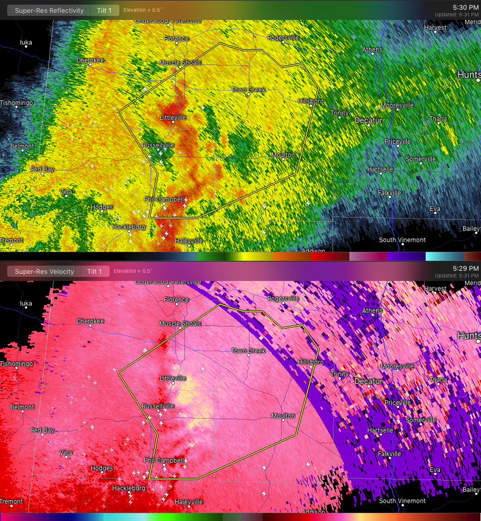

The National Weather Service in Huntsville Alabama has issued a
* Severe Thunderstorm Warning for…
Southeastern Colbert County in northwestern Alabama…
Eastern Franklin County in northwestern Alabama…
Lawrence County in northwestern Alabama…
* Until 600 PM CST.
* At 529 PM CST, severe thunderstorms were located along a line extending from near Littleville to near Russellville to Phil
Campbell, moving northeast at 50 mph.
HAZARD…60 mph wind gusts.
SOURCE…Radar indicated.
IMPACT…Expect damage to roofs, siding, and trees.
* Locations impacted include…
Muscle Shoals, Russellville, Tuscumbia, Moulton, Phil Campbell, Town Creek, Littleville, Leighton, Courtland and North Courtland.
Category: ALL POSTS
About the Author (Author Profile)
Subscribe
If you enjoyed this article, subscribe to receive more just like it.


