Showers & Storms At Midday; Heads Up For Potential Severe Storms On Sunday
NOWCAST AT 12:15 PM
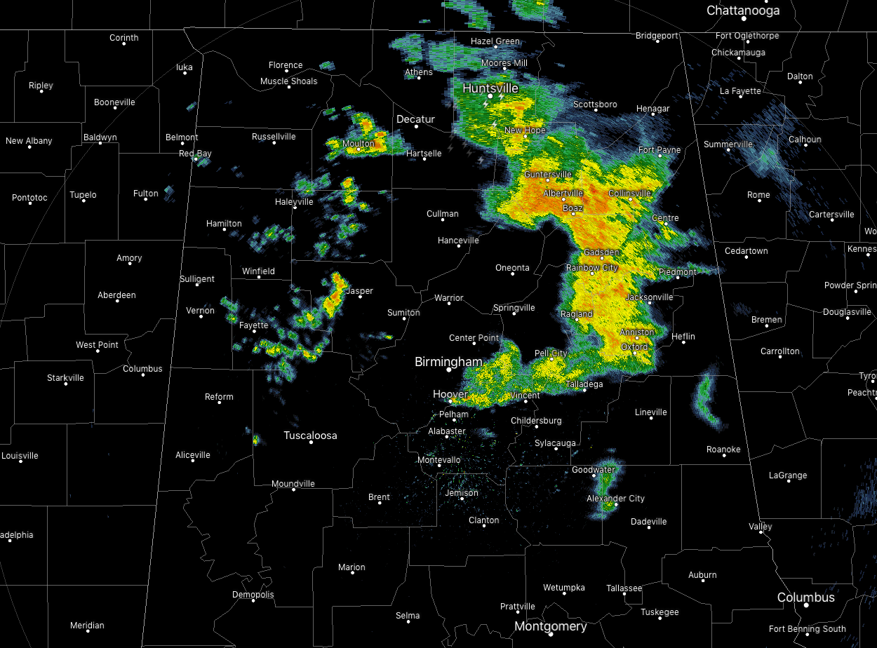
We have some showers and thunderstorms pushing across the eastern parts of North/Central Alabama that are currently affecting Huntsville to Guntersville to Gadsden to Anniston and Oxford. Those are moving to the east at around 35-40 MPH. Behind that, a few spotty to scattered showers have developed over some of the western parts of the area. No lightning involved with these at the moment as these push to the east as well.
Temperatures across Central Alabama are in the upper 50s to the lower 70s with the warm spot being Uniontown at 71 degrees. Birmingham was at 63 degrees while Cullman was the cool spot at 59 degrees.
REST OF TODAY
While those showers and thunderstorms continue to push across the eastern parts of North/Central Alabama, rain chances will start to drop behind those. A few scattered or spotty showers are possible, but those chances drop off to around 30%. We’ll have some sun break through but skies will stay generally mostly cloudy. Afternoon highs top out in the lower 60s to the mid-70s across the area from northwest to southeast. For tonight and through the overnight hours, we’ll continue to have a chance of scattered showers and thunderstorms as a cold front will be moving through the area. The better rain chances will be south of the I-59 corridor. Overnight lows dip down into the lower 40s to the upper 50s across the area from northwest to southeast.
FRIDAY
After the cold front has moved through the area, it will be parked over the extreme southern portions of the state. With it being in such close proximity to the area, a few scattered showers will be possible for the southern parts of Central Alabama, especially south of a line from Eutaw to Montevallo to Lineville. Rain chances increase as you move south but will only be in the 20-30% range. North of that, we’ll have mostly cloudy skies with slightly cooler temperatures. Highs will be in the upper 50s to the lower 70s across the area from morthwest to southeast.
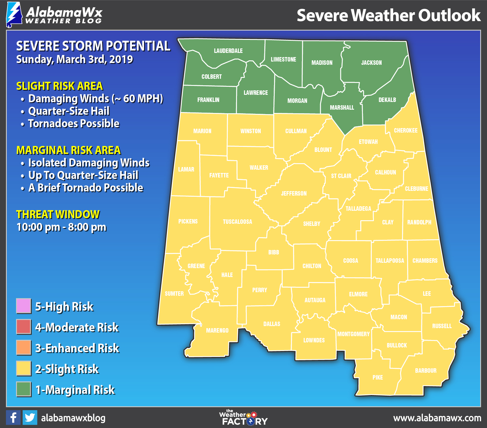
POTENTIAL FOR SEVERE STORMS ON SUNDAY
A strong cold front will be making its way through North/Central Alabama on Sunday, bringing with it a potential for strong to severe storms. At this point, the better risk for severe storms will be across Central Alabama. The Storm Prediction Center already has all of North/Central Alabama defined in a severe storm risk on the Day 4 Outlook graphic valid on Sunday. At this point, all modes of severe weather are possible as we’ll have decent instability and shear in place. We’ll have a better idea on the ingredients when the high-resolution models come into play. The information shown on the outlook map above is from the forecast discussions from both NWS offices in Birmingham and Huntsville.
BEACH FORECAST CENTER
Get the latest weather and rip current forecasts for the beaches from Fort Morgan to Panama City on our Beach Forecast Center page. There, you can select the forecast of the region that you are interested in.
ALREADY OFF TO A HOT START IN 2019! ADVERTISE WITH THE BLOG!
We have enjoyed over 3.6 MILLION page views on AlabamaWx.com so far in 2019! Don’t miss out! We can customize a creative, flexible and affordable package that will suit your organization’s needs. Contact Bill Murray at (205) 687-0782.
E-FORECAST
Get the Alabama Wx Weather Blog’s Seven-Day Forecast delivered directly to your inbox by email twice daily. It is the most detailed weather forecast available in Central Alabama. Subscribe here… It’s free!
CONNECT WITH THE BLOG ON SOCIAL MEDIA
You can find the AlabamaWx Weather Blog on the major social media networks:
Facebook
Twitter
WEATHERBRAINS
Don’t forget you can listen to our weekly 90 minute netcast anytime on the web at WeatherBrains.com or on iTunes, Stitcher, or Spotify. This is the show all about weather featuring many familiar voices, including the meteorologists at ABC 33/40.
Category: Alabama's Weather, ALL POSTS
About the Author (Author Profile)
Scott Martin is an operational meteorologist, professional graphic artist, musician, husband, and father. Not only is Scott a member of the National Weather Association, but he is also the Central Alabama Chapter of the NWA president. Scott is also the co-founder of Racecast Weather, which provides forecasts for many racing series across the USA. He also supplies forecasts for the BassMaster Elite Series events including the BassMaster Classic.Subscribe
If you enjoyed this article, subscribe to receive more just like it.


