Sunny But Cold At Midday; Potential For Severe Storms Late Saturday Into Sunday
CONDITIONS AT 11:15 AM
We have beautiful weather across Central Alabama as we approach the midday hours, but you will definitely need a jacket if you will be heading out for lunch during your break. Temperatures are only in the lower 30s to the lower 40s across the area from northwest to southeast. Birmingham was at 37 degrees, Troy was the warm spot at 43 degrees, and Haleyville was the cold spot at 32 degrees.
SUNNY BUT REMAINING COLD FOR THE REST OF YOUR TUESDAY
We’ll continue to have cobalt blue skies filled with nearly maximum sunshine for the rest of the afternoon and up until sunset. I just wish that the sun would be able to overcome the flow of colder air moving into the area. Afternoon highs will be in the upper 30s to the upper 40 across the area from northwest to southeast. For tonight, skies will be clear which will allow those temperatures plummet into the upper teens to the mid-20s across the area. A Freeze Warning is in effect for all 67 counties in Alabama tonight and through the overnight hours.
ANOTHER BEAUTIFUL AND COLD DAY ON WEDNESDAY
While one or two clouds are possible to float across the sky, Wednesday should be a mainly sunny day. Unfortunately, we’ll have to wait until Thursday before we see a little warm up. Afternoon highs will be in the mid-40s to the lower 50s. Overnight lows will be in the mid-20s to the lower 30s.
POTENTIAL FOR SEVERE STORMS ON LATE SATURDAY INTO EARLY SUNDAY
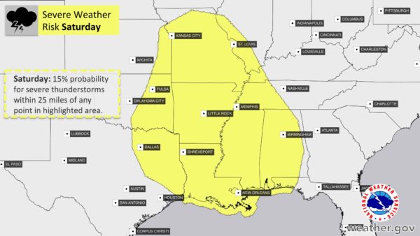
SPC has already defined an area of severe weather on their Day 5 Outlook graphic for Saturday. A strong, dynamic system will be moving through the southeastern United States that has the potential of producing severe thunderstorms. At this point, NWS Birmingham has all of Central Alabama defined in a slight risk of severe storms, with the main threats of tornadoes, damaging winds, and large hail. Timing as of now looks to be from the late evening on Saturday through the early morning hours on Sunday. We’ll have better details on this developing situation as we get closer to the weekend.
We are now in the Spring Severe Weather Season in Central Alabama and we have to watch every system that moves through the area carefully. Now is the time to get a safety kit prepared and have fresh batteries installed in your flashlights, radios, and other portable electronics that could help keep you safe during severe weather.
While some of you may find them annoying, it is important that you have your Wireless Emergency Alerts (WEAs) activated on your smartphones. With people cutting the cord and not having cable or satellite television, WEAs are a great way to inform you when your location goes under a tornado or flash flood warning. Of course, you need to have an NOAA WeatherRadio. These can also alert you when your location goes under any watch, warning, or advisory.
BEACH FORECAST CENTER
Get the latest weather and rip current forecasts for the beaches from Fort Morgan to Panama City on our Beach Forecast Center page. There, you can select the forecast of the region that you are interested in.
CONNECT WITH THE BLOG ON SOCIAL MEDIA
You can find the AlabamaWx Weather Blog on the major social media networks:
Facebook
Twitter
Category: Alabama's Weather, ALL POSTS
About the Author (Author Profile)
Scott Martin is an operational meteorologist, professional graphic artist, musician, husband, and father. Not only is Scott a member of the National Weather Association, but he is also the Central Alabama Chapter of the NWA president. Scott is also the co-founder of Racecast Weather, which provides forecasts for many racing series across the USA. He also supplies forecasts for the BassMaster Elite Series events including the BassMaster Classic.Subscribe
If you enjoyed this article, subscribe to receive more just like it.


