Dry/Cold Again Today; Severe Storms Possible This Weekend
FRIGID START: The calendar says March, but it feels more like January early this morning across Alabama and the Deep South. Here are some temperatures just before sunrise…
Black Creek 17
Cullman 19
Hueytown 20
Pell City 21
Haleyville 21
Fort Payne 21
Bessemer 22
Tuscaloosa 24
Jemison 24
Thorsby 24
Heflin 24
Birmingham 25
Anniston 25
Montgomery 28
Mobile 30
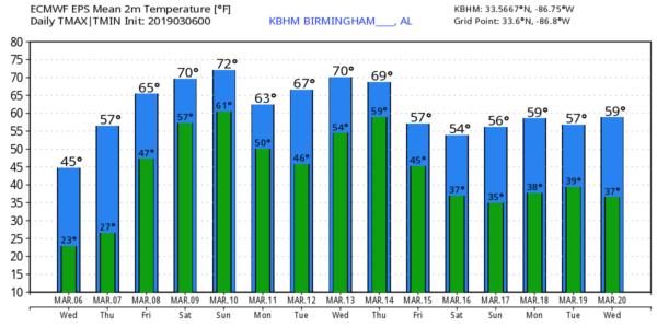
Today will be sunny with a high in the mid to upper 40s across the northern half of the state; temperatures will reach the 50s over South Alabama.
Tonight will be clear and cold, and much of the state will see another freeze early tomorrow morning with a low in the 20s. Then, a warming trend begins tomorrow afternoon as we reach the low 60s with ample sunshine.
Clouds increase tomorrow night, and Friday will be a mostly cloudy day with a few passing showers possible as moisture returns. The high Friday will be in the 60s.
SEVERE STORMS POSSIBLE THIS WEEKEND: A vigorous storm system will develop across the middle of the nation Saturday, and will bring the potential for severe storms to much of the southern U.S. SPC has defined a severe weather risk in a broad zone from eastern parts of Texas and Oklahoma to Tennessee and West Georgia, including basically all of Alabama.
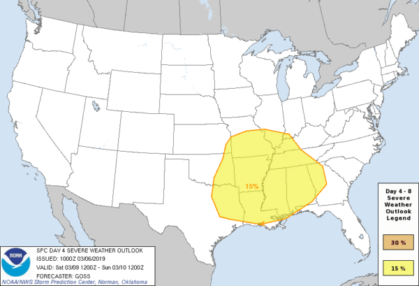
Models have trended a little faster; we now believe the main window for strong to severe storms in Alabama will come from 3:00 p.m. Saturday through 3:00 a.m. Sunday. Based on the projected strong kinematic field, it looks like all modes of severe weather will be possible, including large hail, damaging winds, and a few tornadoes. Rain amounts of 1-2 inches are likely, and for now we are not expecting any major issues with flooding. We will be much more specific about timing/placement tomorrow.
Before the storms arrive, Saturday will be a mild and breezy day with a few scattered showers along with a high in the mid 70s. After the storms, Rain will end very early Sunday, and we expect slow clearing by Sunday afternoon with a high in the low 70s.
NEXT WEEK: Monday and Tuesday look dry with highs in the 60s… the next round of showers and storms will arrive Wednesday or Wednesday night. See the Weather Xtreme video for maps, graphics, and more details.
STORM SURVEYS: A total of 10 tornadoes have been identified by NWS offices in Birmingham and Mobile from Sunday’s severe thunderstorms. EF-0 tornado tracks were discovered today in Autauga and Bullock counties.
ON THIS DATE IN 1962: The strongest nor’easter of this century struck the Mid-Atlantic Region on March 5-9, 1962. It is known as the “Ash Wednesday Storm” and caused over $200 million (1962 dollars) in property damage and major coastal erosion from North Carolina to Long Island, New York. In New Jersey alone, it was estimated to have destroyed or greatly damaged 45,000 homes. The storm killed 40 people. The same storm dropped snow as far as North Alabama.
DST BEGINS: Daylight Saving Time begins Sunday…. set your clocks forward one hour before you go to bed Saturday night. Sunset in Birmingham Sunday will be at 6:51p CDT.
BEACH FORECAST: Click here to see the AlabamaWx Beach Forecast Center page.
WEATHER BRAINS: Don’t forget you can listen to our weekly 90 minute show anytime on your favorite podcast app. This is the show all about weather featuring many familiar voices, including our meteorologists here at ABC 33/40.
CONNECT: You can find me on all of the major social networks…
Facebook
Twitter
Instagram
Pinterest
Snapchat: spannwx
I have a weather program this morning at Brookville Elementary School in Graysville… look for the next Weather Xtreme video here by 4:00 this afternoon. Enjoy the day!
Category: ALL POSTS
About the Author (Author Profile)
James Spann is one of the most recognized and trusted television meteorologists in the industry. He holds the AMS CCM designation and television seals from the AMS and NWA. He is a past winner of the Broadcast Meteorologist of the Year from both professional organizations.Subscribe
If you enjoyed this article, subscribe to receive more just like it.


