One-Half Cloudy, One-Half Sunny At Midday; Severe Storm Potential For The Weekend
CONDITIONS AT 1:10 PM
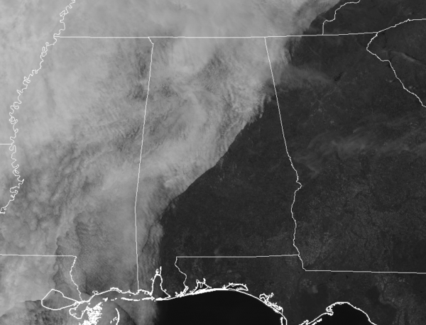
Clouds have moved in and taken over the skies over the northwestern half of Central Alabama as we have now passed the start of the 1 o’clock hour. But in the southeast half of the area, sunshine remains in full force. No rain on the radar at this time, but that might change during the late night and overnight hours. Temperatures at this time are in the upper 40s to the lower 60s across the area from northwest to southeast. Birmingham was at 55 degrees, Troy was the warm spot at 61 degrees, and the cool spot is Haleyville at 48 degrees.
WEATHER FOR THE REST OF YOUR THURSDAY
Clouds will continue to move in from the west throughout the rest of the afternoon and into the evening hours, but no rain will be involved with these clouds. Afternoon highs will be in the lower 50s to the lower 60s. For tonight, skies will be mainly cloudy across the area and we could see some scattered showers move in from the northwest during the pre-dawn hours. Those should stay confined west of the I-59 corridor with chances being higher in the northwest corner of the area. Overnight lows will be in the 40s across the area.
WARMER ON FRIDAY WITH SHOWERS POSSIBLE
Our active weather starts to kick back in on Friday as we’ll have scattered shower chances across much of Central Alabama with the exception of locations mainly along and south of I-85 where they will stay dry during the day. Those chances steadily increase from 20% up to 50% as you reach the I-20 corridor, with showers and a few claps of thunder likely north of that. No severe weather is expected… just general thunderstorms if any lightning occurs. Afternoon highs will be in the lower 60s to the lower 70s. Shower chances fall just a little (20-50%) but pretty much stay in the same general locations for the late night and overnight hours. Lows will be in the 50s.
POTENTIAL FOR STRONG TO SEVERE STORMS THROUGHOUT THE WEEKEND
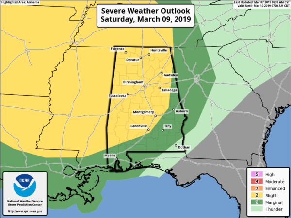
SPC has a Slight Risk for severe storms for locations west of a line from Cedar Bluff (Cherokee Co.) to Camp Hill (Tallapoosa Co.) to Pike Road (Montgomery Co.) throughout the day on Saturday, while the rest of Central Alabama east of that line is in a Marginal Risk. Tornadoes, damaging winds, and quarter-size hail are possible starting as early as 12:00 pm on Saturday through the early morning hours on Sunday.
NWS Birmingham has all locations of Central Alabama south of a line from Cuba (Sumter Co.) to Jamison (Chilton Co.) to Ranburne (Cleburne Co.) defined in a Marginal Risk for severe storms throughout the day on Sunday until 9:00 pm. Damaging winds, large hail, and a brief tornado or two are possible.
At this point, a cold front bringing with it a line of strong to possibly severe storms for the northwestern parts of the state as early as noon on Saturday and slowly progressing to the southeast before stalling out over the south-central parts of Central Alabama late Saturday night and hangsanaround through Sunday. The system will gradually weaken as it is stalled out, so the threat of severe storms will lessen somewhat.
There may be the possibility of a few cells developing out ahead of the cold front that could be strong to severe on Saturday, but we’ll know more details on that possibility within the next day. We’ll keep you updated on any changes.
CALL TO ACTION
We are now in our Spring Severe Weather Season in Alabama. It is very common for us to have severe weather threats like this. That is why you have to be prepared just in case your location goes under a warning.
Be sure you have a reliable way of hearing warnings. Never rely on outdoor sirens. You do not have much hope if you use a siren as your main way of receiving a warning. Every home needs a NOAA WeatherRadio… and if you have one, now is the perfect time to put new batteries in it. Enable the Wireless Emergency Alerts (WEAs) on your phone.
If living in a mobile or manufactured home and you go under a tornado warning, you MUST leave and be in a site built home or structure, or a shelter. NOW is the time to talk over these things with your family and be sure that everyone understands the plan.
Category: Alabama's Weather, ALL POSTS
About the Author (Author Profile)
Scott Martin is an operational meteorologist, professional graphic artist, musician, husband, and father. Not only is Scott a member of the National Weather Association, but he is also the Central Alabama Chapter of the NWA president. Scott is also the co-founder of Racecast Weather, which provides forecasts for many racing series across the USA. He also supplies forecasts for the BassMaster Elite Series events including the BassMaster Classic.Subscribe
If you enjoyed this article, subscribe to receive more just like it.


