A Few Showers At Midday; Severe Risks Reduced Somewhat For Saturday
FRIDAY’S WEATHER
Sorry for the delay in getting the midday forecast out to you. I was in the middle of typing out the details for Saturday’s severe weather threat with the outlook graphic from the Storm Prediction Center, but they released an update that turns out to be much better news for the area. More on that in a little bit.
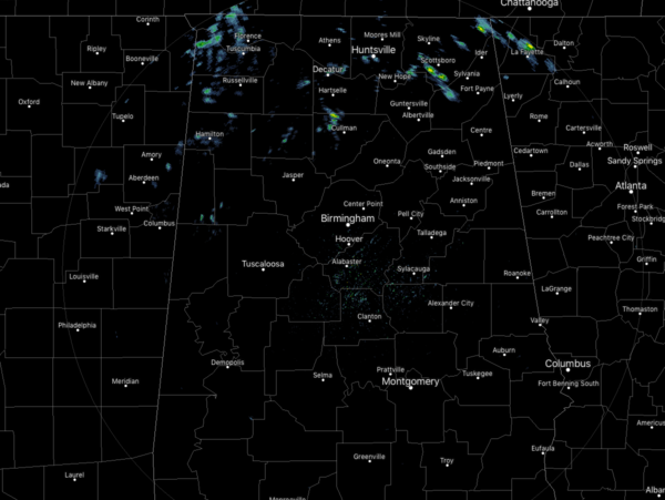
At this point, there are just a few scattered light showers over the northern parts of the state, while everyone south of the I-59 corridor dry. Much of North/Central Alabama has cloud cover with the exception of the southeastern quarter of the area which has partly cloudy skies. Temperatures are currently in the mid-50s to the lower 70s across Central Alabama, while in the upper 40s to the mid-50s in North Alabama. The cold spot is Scottsboro at 48 degrees while the warm spot is Tuscaloosa at 73 degrees. Birmingham was at 68 degrees as of 12:18 pm.
We’ll have some showers move across the northern half of the state throughout the rest of the afternoon and into the early evening hours. Chances range from 20% along and north of the I-85 corridor and increase to around 70% in the northern parts of the area. South of the I-85 corridor should stay dry. Afternoon highs will be in the 60s to the lower 70s from north to south. For tonight and through the overnight hours, skies will be cloudy and shower chances continue for the same locations. Overnight lows will be in the 50s.
DAYLIGHT SAVING TIME STARTS SUNDAY
That’s right folks, we get to move our clocks ahead one hour before heading off to bed on Saturday night. We also now have to get used to writing or typing CDT (Central Daylight Time) instead of CST (Central Standard Time).
SEVERE STORM POTENTIAL CONTINUES BUT SHIFTING MORE NORTHWEST
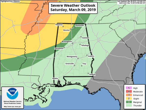
The SPC has reduced the Slight Risk of severe storms for Saturday for just the northwestern parts of the state, west of a line from Macedonia (Pickens Co.) to Addison (Winston Co.) to Harvest (Madison Co.). A Marginal Risk has been defined for locations east of the slight risk to a line stretching from Geiger (Sumter Co.) to Warrior (Jefferson Co.) to Stevenson (Jackson Co.)
The highest tornado threat will be over the northwestern parts of Mississippi, western parts of Tennessee, and northeastern parts of Arkansas… but we could see a couple of tornadoes and damaging wind gusts up to 60 MPH in those risk locations.
The window for stronger to severe storms over the northern half of the state looks to be from 3:00 pm Saturday to 3:00 am Sunday. We will probably have two rounds of storms with scattered activity through the afternoon and evening hours, with a squall line along with the cold front moving into the northwestern parts of Alabama around 10:00 pm to 12:00 am. The front will progress slowly to the southeast and stall somewhere over the southern portions of Central Alabama on Sunday afternoon.
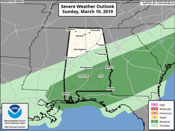
A Marginal Risk for severe storms has been defined across parts of Central Alabama on Sunday. Locations south of a line from Sweet Water (Marengo Co.) to Wetumpka (Elmore Co.) to La Fayette (Chambers Co.) have the potential for isolated damaging wind gusts up to 60 MPH and a brief spin-up tornado or two. The window for stronger to severe storms in the Marginal Risk locations look to be from 12:00 pm through 10:00 pm.
While the setup through the weekend is not as potent as what we saw last weekend, we still have to be vigilant with severe storms as we are now in our Spring Severe Weather Season in Alabama. If you strictly rely on outdoor sirens for your way of receiving warnings, you don’t have much hope. Every phone needs to have WEAs (Wireless Emergency Alerts) activated and every home needs a NOAA WeatherRadio.
Every home also needs a severe weather safety kit along with an action plan ready to go if your location comes under a warning. If you live in a mobile home and you are in a polygon, you MUST leave and find safety in a more sturdy structure or a tornado shelter. Talk over these things with your household and make sure everyone understands exactly what to do.
Category: Alabama's Weather, ALL POSTS
About the Author (Author Profile)
Scott Martin is an operational meteorologist, professional graphic artist, musician, husband, and father. Not only is Scott a member of the National Weather Association, but he is also the Central Alabama Chapter of the NWA president. Scott is also the co-founder of Racecast Weather, which provides forecasts for many racing series across the USA. He also supplies forecasts for the BassMaster Elite Series events including the BassMaster Classic.Subscribe
If you enjoyed this article, subscribe to receive more just like it.


