New Tornado Watch Just to Our West
The NWS Storm Prediction Center has issued a
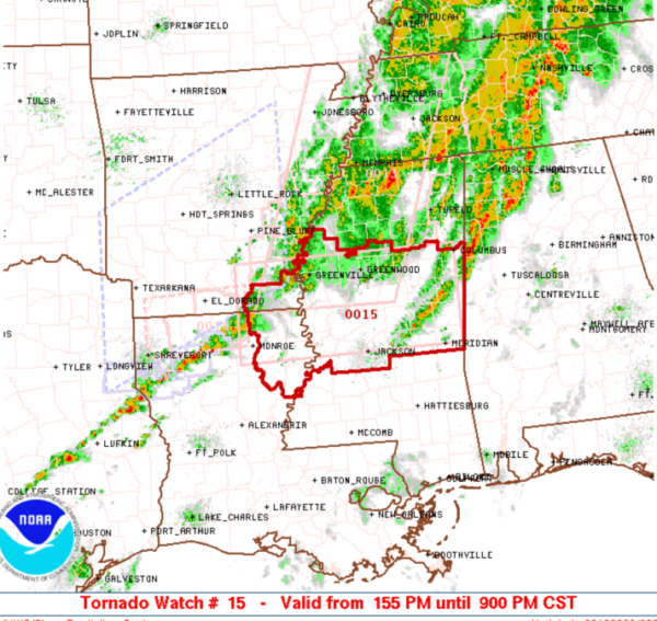
* Tornado Watch for portions of
Extreme southeastern Arkansas
Northeast Louisiana
Much of central Mississippi
* Effective this Saturday afternoon and evening from 155 PM until
900 PM CST.
* Primary threats include…
A few tornadoes likely with a couple intense tornadoes possible
Scattered damaging wind gusts to 70 mph likely
Scattered large hail events to 1.5 inches in diameter possible
SUMMARY…A broken band of storms, some with supercell structures,
will continue to spread eastward from Louisiana and southeast
Arkansas into Mississippi through the afternoon/evening. Other
severe storm development will also be possible farther east in the
warm sector. The storm environment remains favorable for supercells
capable of producing tornadoes, damaging winds, and large hail. The
strongest storms could produce a strong tornado or two.
The tornado watch area is approximately along and 50 statute miles
north and south of a line from 35 miles north northwest of Monroe LA
to 40 miles south of Columbus MS. For a complete depiction of the
watch see the associated watch outline update (WOUS64 KWNS WOU5).
PRECAUTIONARY/PREPAREDNESS ACTIONS…
REMEMBER…A Tornado Watch means conditions are favorable for
tornadoes and severe thunderstorms in and close to the watch
area. Persons in these areas should be on the lookout for
threatening weather conditions and listen for later statements
and possible warnings.
Category: Alabama's Weather, ALL POSTS
About the Author (Author Profile)
Macon, Georgia Television Chief Meteorologist, Birmingham native, and long time Contributor on AlabamaWX. Stormchaser. I did not choose Weather, it chose Me. College Football Fanatic. @Ryan_StinnetSubscribe
If you enjoyed this article, subscribe to receive more just like it.


