

Strong To Severe Storm Potential Continues For Later Today

As of 8:50 am, nearly all of North/Central Alabama is free from rainfall with the exception of a few spotty returns showing up over the northeastern parts of the area over Etowah and Dekalb counties, but those may not even be reaching the ground. Skies are mainly cloudy across the area, but there are a few breaks allowing for some sun to peak through.
The main action at this point is back to our west and northwest as the line of storms is stretching from western Indiana and eastern Illinois down through western Kentucky and Tennessee and down through northwestern Mississippi and into Louisiana. A Tornado Watch is in effect for parts of Tennessee, Mississippi, and Arkansas until 12:00 pm CDT. There was only one sSevere Thunderstorm Warning that was in effect in Illinois and Kentucky, but it expires at 9:00 am.
The Storm Prediction Center continues an Enhanced Risk of severe storms for a good chunk of North Alabama, including the cities of Florence, Muscle Shoals, Hamilton, Jasper, Warrior, Cullman, Decatur, Huntsville, Guntersville, and Scottsboro. A Slight Risk extend out to include locations north of a line from Demopolis to Childersburg to Centre. A Marginal Risk extends south from that to a line stretching from Selma to Rockford to Fruithurst.
Threats include tornadoes, damaging winds, and hail of quarter-size or larger.
The line of storms to our west at this point is expected to weaken throughout the morning, but with the heating of the day, more storms are expected to develop with the heating of the day and as the instability rises.
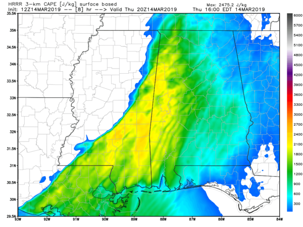
The latest HRRR is showing that instability will be highest in North/Central Alabama around the 3:00 pm-4:00 pm time frame, topping out above 2,000 J/kg ver the western parts of the area. Shear values will be high over the area at the same time, with values reaching 500 m2/s2.
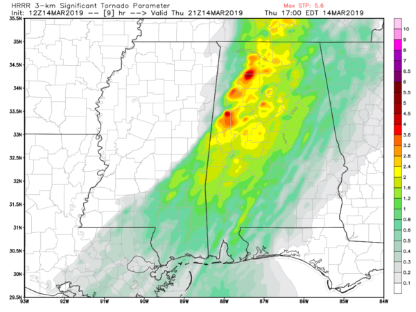
Significant Tornado Parameter values are rather high across the area in the latest HRRR model run as well, maxing out over 5.0 around the same time frame over the northwestern and western parts of the area.
Timing for the better chance of severe storms across North/Central Alabama will be from roughly 3:00 pm this afternoon through 1:00 am Friday from northwest to southeast in the severe storm risk areas.
Have your severe weather safety plan and safety kit ready to go now. If you wait until you go under a warning, it is too late. Have a trusty way to receive warnings, especially a NOAA WeatherRadio or a great phone app like MyWarn. Also, have WEAs (Wireless Emergency Alerts) activated on your phone.
We’ll have more updates throughout the day. Check back often. Also follow us on Twitter at @AlabamaWxBlog.
Category: Alabama's Weather, ALL POSTS, Severe Weather
About the Author (Author Profile)
Scott Martin is an operational meteorologist, professional graphic artist, musician, husband, and father. Not only is Scott a member of the National Weather Association, but he is also the Central Alabama Chapter of the NWA president. Scott is also the co-founder of Racecast Weather, which provides forecasts for many racing series across the USA. He also supplies forecasts for the BassMaster Elite Series events including the BassMaster Classic.Subscribe
If you enjoyed this article, subscribe to receive more just like it.


