The Severe Thunderstorm Warning For Southeastern Walker County Is Cancelled

…THE SEVERE THUNDERSTORM WARNING FOR SOUTHEASTERN WALKER COUNTY IS CANCELLED…
The storm which prompted the warning has moved out of the area. Therefore, the warning has been cancelled. A Tornado Watch remains in effect until 700 PM CDT for central Alabama.
A Severe Thunderstorm Warning Remains In Effect Until 5:15 PM CDT For Southeastern Walker County
Mar 14th @ 4:46 pm

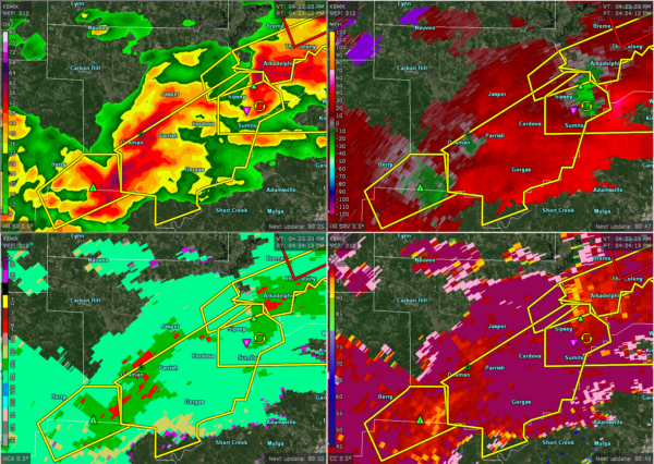
…A SEVERE THUNDERSTORM WARNING REMAINS IN EFFECT UNTIL 515 PM CDT FOR SOUTHEASTERN WALKER COUNTY… At 446 PM CDT, a severe thunderstorm was located over Burnwell, or near Dora, moving northeast at 45 mph.
HAZARD…60 mph wind gusts and quarter size hail.
SOURCE…Radar indicated.
IMPACT…Hail damage to vehicles is expected. Expect wind damage to roofs, siding, and trees. Locations impacted include… Sumiton, Cordova, Dora, Sipsey, Gorgas Steam Plant, Rocky Hollow, Burnwell, Beloit, Quinton, Gorgas, Goodsprings, Barney and Empire.
A Severe Thunderstorm Warning Remains In Effect Until 5:15 PM CDT For Southeastern Walker County
Mar 14th @ 4:35 pm

…A SEVERE THUNDERSTORM WARNING REMAINS IN EFFECT UNTIL 515 PM CDT FOR SOUTHEASTERN WALKER COUNTY… At 434 PM CDT, a severe thunderstorm was located near Gorgas, or 10 miles southwest of Cordova, moving east at 45 mph.
HAZARD…60 mph wind gusts and quarter size hail.
SOURCE…Radar indicated.
IMPACT…Hail damage to vehicles is expected. Expect wind damage to roofs, siding, and trees. Locations impacted include… Sumiton, Cordova, Dora, Parrish, Sipsey, Gorgas Steam Plant, Rocky Hollow, Burnwell, Beloit, Quinton, Gorgas, Lynns Park, Goodsprings, Barney, Empire, The Wye and Tutwiler.
Severe Thunderstorm Warning Issued For Parts Of Walker County Until 5:15PM
Mar 14th @ 4:24 pm

The National Weather Service in Birmingham has issued a
* Severe Thunderstorm Warning for…
Central Walker County in central Alabama…
* Until 515 PM CDT.
* At 424 PM CDT, a severe thunderstorm was located near Boley
Springs, or 15 miles southwest of Cordova, moving northeast at 45 mph.
HAZARD…60 mph wind gusts and quarter size hail.
SOURCE…Radar indicated.
IMPACT…Hail damage to vehicles is expected. Expect wind damage to roofs, siding, and trees.
* Locations impacted include…
Jasper, Sumiton, Cordova, Dora, Parrish, Oakman, Sipsey, Gorgas
Steam Plant, Rocky Hollow, Burnwell, Beloit, Quinton, Gorgas, Lynns
Park, Goodsprings, Barney, Empire, The Wye and Tutwiler.
Category: ALL POSTS
About the Author (Author Profile)
Subscribe
If you enjoyed this article, subscribe to receive more just like it.


